Welcome to the Virtual Base Camp, the starting point for your exploration of the polar regions with PolarTREC teachers and researchers!
2014 Expedition Timeline
Expeditions
Totten Glacier System in East Antarctica
What Are They Doing?

This project conducted a ship-based marine geologic and geophysical survey of the region, combined with a physical oceanographic study. The results have added to our understanding of the oceanographic and glacial system and its potentially sensitive response to environmental change. This endeavor complemented studies of other Antarctic ice shelves, oceanographic studies near the Antarctic Peninsula, and ongoing development of ice sheet and other ocean models.
Expedition Map
Joint Antarctic School Expedition 2014
What Are They Doing?
¿Qué están haciendo?
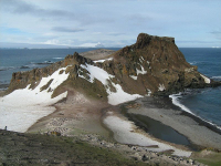
Los estudiantes y maestros pasarán cinco días en la Isla Rey Jorge aprendiendo sobre los proyectos de investigación científica que se llevan a cabo cerca de la base Escudero. El programa podría incluir visitas a la Playa Elefanteras para estudiar elefantes marinos y pingüinos; al Galciar Collins donde crecen musgos, pastos y algas en el hielo; o al domo Bellingshausen para aprender sobre estudios en glaciología. También tendrán la oportunidad de visitar otras estaciones chilenas de investigación, así como las estaciones científicas de otros paises que también están localizadas en la Isla Rey Jorge.
Expedition Map
Airborne Survey of Polar Ice 2014
What Are They Doing?
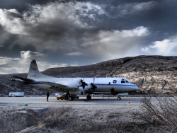
Operation IceBridge began in 2009 to bridge the gap in data collection after NASA's ICESat satellite stopped functioning and when the ICESat-2 satellite becomes operational in 2016, making IceBridge critical for ensuring a continuous series of observations of polar ice. IceBridge flies over the Arctic and Antarctic every year—in the Arctic from March to May and the Antarctic in October and November. By comparing the year-to-year readings of ice thickness and movement both on land and on the sea, scientists can look at the behavior of the rapidly changing features of the polar ice and learn more about the trends that could affect sea-level rise and climate around the globe. More information about IceBridge can be found at the NASA project website.
Expedition Map
Arctic Ground Squirrel Studies 2014
What Are They Doing?
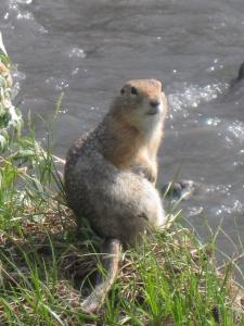
The research team has recently found that the arctic ground squirrel displays daily rhythms of body temperature throughout the arctic summer, in the absence of a light-dark cycle. The current study will investigate the circadian rhythms in arctic ground squirrels during the continuous daylight present during the active summer season and continuous dark of the 6-8 months of hibernation spent sequestered in a burrow. The team wants to understand why arctic ground squirrels, unlike other arctic vertebrates, appear to maintain 24-hour rhythms during the active season. They hypothesize that the persistence of circadian rhythmicity allows ground squirrels to reduce energy expenditure by anticipating predictable changes in its immediate surroundings. They are testing their hypothesis by experimentally phase-shifting free-living ground squirrels to be active at 'night' and estimating their subsequent rates of energy expenditure.
Expedition Map
Climate Change and Pollinators in the Arctic
What Are They Doing?

This work can have important pan-Arctic and global implications. The majority of flowering plants in nature and one third of our crop plants depend on pollinators to produce fruits and seeds. As temperatures rise in the Arctic, successful adaptation and range expansion of many plants, including plants migrating into the Arctic, will depend on pollinators. This study will help us determine which mechanisms may most strongly drive changes in plant-pollinator interactions and plant reproduction.
Expedition Map
Microbial Changes in Arctic Freshwater
What Are They Doing?
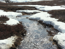
To date, the researchers have found that microbial communities in lakes and rivers change dramatically through the seasons but reassemble on an annual basis. They have also found that community composition in soil and surface waters shifts within days in response to environmental fluctuations in temperature or dissolved organic matter composition. They have also found that upland terrestrial habitats act as landscape-level seedbanks for lowland aquatic systems. The ultimate goal of the project is to develop a greater understanding of the controls on microbial community composition and function over space and time.
Expedition Map
Arctic Sunlight and Microbial Interactions 2014
What Are They Doing?

Tremendous stores of organic carbon frozen in permafrost soils have the potential to greatly increase the amount of carbon in the atmosphere. Permafrost soils may thaw sporadically and melting ground ice can cause land-surface sinking called "thermokarst failures". These failures change the rate and amount of carbon released with the unanticipated outcome being that soil carbon can be mixed-up from a depth and exposed to sunlight as the land surface is altered. Sunlight can photo-degrade or break-down organic carbon and alter the carbon's ability to support bacterial respiration to produce carbon dioxide. Whether sunlight and UV exposure will enhance or retard the conversion of newly exposed carbon to carbon dioxide is currently unknown—this study is providing the first evidence that this alteration will be amplified by photochemical processes and their effects on microbes.
The research team is trying to understand exactly how sunlight and bacteria degrade dissolved organic matter by determining how fast these processes convert newly released dissolved organic matter to carbon dioxide, compared to dissolved organic matter already in surface waters. The team is accomplishing their research objectives with a series of laboratory experiments to determine rates of photodegradation and microbial processing of dissolved organic matter from different sources, and a series of landscape comparisons and sampling transects to characterize dissolved organic matter degradation in small basins and large rivers extending from the headwaters to the Arctic Ocean. Ultimately, this research will attempt to answer questions such as whether carbon export from tundra to oceans will rise or fall and how reactive the exported carbon will be. The team hopes to be able to measure the ultimate impact of impending disturbances, including climate change, on the net carbon balance of the Arctic and its interaction with the global carbon cycle.
Expedition Map
Joint Science Education Project 2014
What Are They Doing?

This year's work builds on past expeditions and is supported by the National Science Foundation. The project was developed through cooperation with the U.S.-Denmark-Greenland Joint Committee, which was established in 2004 to broaden and deepen cooperation among the United States, the Kingdom of Denmark, and Greenland.
The program has two components
Kangerlussuaq Science Field School and Science Education Week
Expedition Map
Historical Ecology for Risk Management 2014
What Are They Doing?
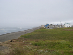
The project emphases are 1) a bibliographic database of relevant historical resources, 2) an examination of the shoreline to provide a long time-series baseline, 3) simulation models to demonstrate socio-natural cycles of change for the North Slope shoreline, 4) the historical ecology study of the shoreline, interactive mapping and database available as a web based resource to assist academia, industry, regional government and local communities for socio-natural risk management (e.g., Barrow Area Information Database, 5) an integrated team of researchers, corporations, community planners, and Risk Management of the North Slope Borough to extract data and provide simulation models that apply to current studies and hazards of the region, especially mitigation tools for community decisions, and 6) provide a variety of eco-heritage opportunities that include community participation in research, educational products, age level appropriate activities and outreaches for community service learning, such as Teen CERT for the Next Generations and PolarTREC.
Expedition Map
High Arctic Change 2014
What Are They Doing?

The research team, which includes undergraduate geoscience students participating in the Research Experiences Undergraduates (REU) Program, traveled to Svalbard to research how high latitude glaciers, melt-water streams, and sedimentation in the fjords reflect climate. The Svalbard region is ideal for the study of past climate because several different types of measurements on and around glaciers can be conducted there. Working out of small boats in the fiord and hiking to sites on land, the team collected data to determine what relationships exist between current sedimentation, glaciers, oceans, and climate. Using the historic sedimentation record can help the researchers understand and better predict how glacial systems react to climate change.
Expedition Map
Oceanographic Conditions of Bowhead Whale Habitat 2014
What Are They Doing?

¿Quienes son?
Titulo financiado: Observación anual del medio ambiente marino biológico y físico en los mares Chukchi y Beauford en las cercanías de Barrow, AK.
El equipo de investigación viajará por avión a Barrow, una comunidad pequeña de aproximadamente 4,500 habitantes en la costa norte de Alaska. Como permitan las condiciones del tiempo, el equipo se embarcara para la colección de muestras oceanográficas a bordo del buque de investigación Annika Marie de 43 pies. Las actividades de a bordo incluirán colección de agua y plancton y mediciones de conductividad, temperatura, y profundidad. A bordo también tomarán nota sobre las ocurrencias de mamíferos marinos y realizarán el procesamiento preliminar de muestras. Si el clima es malo para navegar en el océano ellos pasarán el tiempo en Barrow catalogando muestras y organizándose para los días que pasaran sobre el agua.
Expedition Map
Shrinking Arctic Icecaps
What Are They Doing?

The research team applied complimentary techniques to both the preserved plants and rocks exposed at the foot of retreating glaciers in West Greenland. Radiocarbon-dating techniques were applied to the plants and the isotopic signature of recently exposed rock surfaces were determined, allowing researchers to determine the duration of ice-covered and ice-free conditions throughout the Holocene (the past 11,700 years since the end of the last major ice age). Combined, these two datasets explicitly date when the region was last as warm as present. Comparing climate reconstructions with on-going studies elsewhere will help to further define recent abrupt climate changes.
Expedition Map
Sea Floor Changes and the Antarctic Circumpolar Current
What Are They Doing?
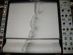
The past opening of deep Southern Ocean gateways between Antarctica and South America and between Antarctica and Australia permitted the complete circulation of the Antarctic Circumpolar Current (ACC). This opening may have been critical in the transition from a warm Earth in the past, to the subsequently much cooler conditions that persist to the present day. The opening of Drake Passage and the West Scotia Sea probably broke the final barrier formed by the Andes of Tierra del Fuego and the 'Antarctandes' of the Antarctic Peninsula. It is thought that once this deep gateway, usually referred to simply as the Drake Passage gateway (DPG), was created, the strong and persistent mid-latitude winds likely generated one of the largest deep currents on Earth. This event is widely believed to be closely associated in time with a major, abrupt drop in global temperatures and the rapid expansion of the Antarctic ice sheets 33-34 million years ago. On an earlier cruise to the Central Scotia Sea on board Nathaniel B. Palmer, however, Dalziel and Lawver and their colleagues found evidence that there may have been a barrier to eastward flow from Drake Passage to the South Atlantic Ocean basin until 10-12 million years ago when the planet descended even more deeply into an 'icehouse' state.
The research team dredged seafloor samples and analyzed them for their age and composition to determine if they may indeed have once blocked the Antarctic Circumpolar Current. They mapped the sub-seafloor to see how and/or if South Georgia is colliding with the North East Georgia Rise and with their co-investigator Robert Smalley of the University of Memphis they installed three GPS units on South Georgia to determine its horizontal and vertical motion. It is notable that the mountains of the island, which the explorer Ernest Shackleton and his companions had to cross after their celebrated small boat journey from Antarctica, are three times as high as the equivalent part of the Andean Cordillera in Tierra del Fuego.
Expedition Map
Microbialites In Lake Joyce Antarctica
What Are They Doing?
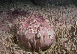
The research team studied the communities in Lake Joyce, Antarctica in several different ways. They took images of the stromatolites in Lake Joyce and reconstructed the 3D morphology of microbial mats in the lake. They also characterized the environment that the stromatolites are growing in and studied how the morphology of the stromatolites varies mud deposition and calcite mineral formation. They also directly sampled the stromatolites to study the distribution of photosynthesis, calcite mineral formation, and mud incorporation.
They expect this study to make several important contributions to understanding early life on Earth. Morphological studies of the stromatolites will provide insights into how microbial communities build intricate structures and how variations in environment and ecology affect morphology. Results will also help researchers understand how microbial communities influence calcite mineral growth and how this affects stromatolite morphology. Results will be directly applicable to better interpreting ancient stromatolites, providing insights into ecological and biogeochemical processes on early Earth. Finally, a better understanding of the processes by which microbial communities build stromatolites will aid in the search for evidence of life on other planets, such as Mars, where landed missions have access to sedimentary rocks.
Expedition Map
Tectonic History of the Transantarctic Mountains 2014
What Are They Doing?
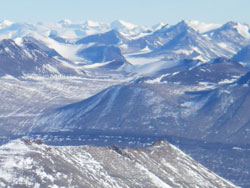
The goal of this project, funded by the National Science Foundation, is to broaden our knowledge of the geology in this region with a new seismic array; the Transantarctic Mountains Northern Network (TAMNNET), a 15-station array across the northern TAMs and the WSB that helps fill a major gap in seismic coverage. Data from TAMNNET is being combined with that from previous and ongoing seismic initiatives and is analyzed to generate an image of the seismic structure beneath the TAMs and the WSB.
While in the field, the team spent most of their time servicing the seismic stations that compose the new TAMNNET array. This included loading equipment onto small airplanes, flying to remote field locations, uncovering the deployed equipment, and checking for any maintenance issues. The first batch of data from the network was also retrieved during this time.
Expedition Map
Weddell Seals in the Ross Sea 2014
What Are They Doing?

This data was collected and analyzed in an attempt to learn more about what drives the timing of a seal's critical life history events – such as breeding and molting – and how disruptions in that natural cycle by changes in climate and environment might affect the world's southernmost mammal.
Expedition Map
West Antarctic Ice Sheet Microstructures
What Are They Doing?

This project specifically investigated the ice microstructure, impurity content, and ice-flow patterns in relation to climate history for the ice near the West Antarctic Ice Sheet (WAIS) ice core site, using a combination of borehole logging, modeling, and thin section analyses. This work was the first to combine two novel advanced techniques for studying the relationship between ice microstructure, deformation, and climate history. More information about the project can be found here.
Expedition Map
Ice Cube Neutrino Observatory 2014
What Are They Doing?
All neutrino detectors rely on observing the extremely rare instances when a neutrino does interact with a proton or neutron. This transforms the neutrino into a charged particle of the same type as the neutrino flavor (electron, muon, or tau). Muons are charged particles that can travel for 5-10 miles (8-16 kilometres) through matter depending on their energy, and generate detectable light in translucent media.
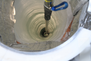
IceCube is made up of thousands of sensitive light detectors embedded in a cubic kilometre of ice between 1450 m and 2450 m below surface. The sensors are deployed on strings in the ice holes that were made using a hot water drill. IceCube detects about 100,000 neutrinos a year, and has a projected life time of two decades. The data collected will be used to make a "neutrino map" of the universe and to learn more about astronomical phenomena, like gamma ray bursts, black holes, exploding stars, and other aspects of nuclear and particle physics. However, the true potential of IceCube is discovery; the opening of each new astronomical window leads to unexpected discoveries.


