Welcome to the Virtual Base Camp, the starting point for your exploration of the polar regions with PolarTREC teachers and researchers!
2018 Expedition Timeline
Expeditions
Chemical Ecology of Shallow Water Marine Communities
What Are They Doing?
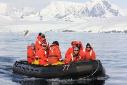
Researchers will focus on the chemical ecology of shallow-water marine macroalgae and invertebrates on the Antarctic Peninsula. The team will study the ecosystem connections between macroalgae and crustaceans like amphipods (including gastropods). Particularly they want to know more about the benefits and costs to amphipods from being uniquely able to consume particular macroalgae and some other chemically defended red algae. Another focus is on the basis and implications of the substantial chemodiversity previously observed in macroalgal defenses. The investigators also seek to definitively demonstrate that some amphipods retain metabolite defenses from particular macroalgae, to defend itself from predation.
Expedition Map
Phenology and Vegetation Change in the Warming Arctic
What Are They Doing?
The goal of this expedition is to understand arctic terrestrial change by monitoring vegetation communities in northern Alaska associated with the International Tundra Experiment Arctic Observatory Network (ITEX-AON). The team will study environmental variability and increased temperature on tundra plant phenology, growth, species composition and ecosystem function.
The ITEX network works collaboratively to study changes in tundra plant and ecosystem responses to experimental warming. The network monitoring sites are located across many major ecosystems of the Arctic.
This project will provide urgently needed data critical to understanding the impact of multi-scale vegetation change on ecosystem function, namely land-atmosphere carbon and water fluxes and energy balance.
Expedition Map
Jellyfish in the Bering Sea 2018
What Are They Doing?
Eastern Bering Sea (EBS) jellyfish populations have fluctuated dramatically during the past three decades. When jellyfish populations are high, they likely have major impacts on the Bering Sea food web. This project will estimate the age structure and age-specific abundances of the predominant jellyfish in the Bering Sea, Chrysaora melanaster, in order to understand how their population size changes with time.
The ultimate goal is to estimate the reproductive capacity and success of this jellyfish in relation to climate variability and to investigate the potential for jellyfish population increases to become a recurring pattern in the Bering Sea under future climate scenarios. This will in turn enable forecasting of jellyfish abundance and their predatory impacts in the Bering Sea ecosystem.
Expedition Map
Migration and Carry-Over Effects in Arctic Seabirds
What Are They Doing?
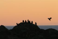
Seabirds are considered to be ecosystem sentinels; their productivity and populations rely on availability of zooplankton and forage fish species. Long-term data suggest that conditions seabirds experience during the non-breeding season might have a large impact on their reproductive output and survival.
This project will help us understand the non-breeding ecology of seabirds. This need is especially pressing in areas of the Arctic undergoing changes in winter sea ice dynamics and increases in natural resource development. Using the data they collect, the team will develop a conceptual model of how warming in the Pacific Arctic will alter the region’s food web structure which is important for seabird conservation and management.
Expedition Map
Shrubs Snow and Nitrogen in the Arctic
What Are They Doing?
Ecosystems develop and change through interactions between living things and their physical environment. A shift in vegetation is one of the most important changes an ecosystem can experience, because it can alter exchanges of energy (originating from sunlight), water, and elements such as carbon (C) and nitrogen (N) between air, plants, and soil. In the Arctic, a widespread shift from tundra to deciduous shrub-dominated vegetation appears to be occurring.
This project will assess contributions of different shrub feedbacks to carbon and nitrogen cycling, and improve predictions of the consequences of shrub expansion in the Arctic for regional and global climate.
Expedition Map
Permafrost and Community
What Are They Doing?
Alaska’s land, water, plants, wildlife, and seasons are undergoing a great upheaval, and its people, especially the tribal communities living in remote villages are directly and severely impacted by these changes. The project will provide the traditionally-underserved tribal communities of the Upper Kuskokwim region the motivation, resources, climate science knowledge and skills to study the impact of climate change on their tribal way of life and environment.
The project will establish local climate and permafrost observation system and map land cover and permafrost in the Upper Kuskokwim region. It will also develop a geo-hazard map for the region to facilitate safe subsistence and recreational practices and land use. The data, knowledge, and skills gained through this project will benefit the tribal communities in implementation of safe land use practices, and planning for the future.
Expedition Map
Sliding Glaciers
What Are They Doing?
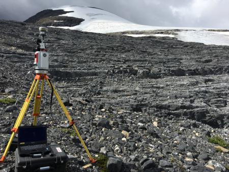
The team is developing mathematical relationships needed to predict the sliding speeds of glaciers and ice sheets. The uncertainty of these relationships, called sliding laws, introduces major uncertainty in the results of computer models aimed at predicting ice-sheet flow and associated sea-level rise. Improved sliding laws are developed by visiting forefields of seven receding glaciers in the Swiss Alps and measuring in detail the topography of their exposed former beds. This topography is then used as the basis for computer models of glacier sliding that allow sliding laws to be derived. The field site is not in a polar region but the team's work can help predict glacial change that may occur at the poles in the future.
Expedition Map
Winter Respiration in the Arctic
What Are They Doing?
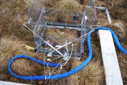
This NASA-funded project aims to improve understanding seasonal changes in the amount of carbon dioxide (CO2) released from permafrost soils in Alaska. This project is very exciting because they are using soil flux chambers that are capable of monitoring CO2 during the cold winter months. Information resulting from this study will be used to improve the understanding of local earth systems processes that affect carbon flux in various parts of Alaska.
Expedition Map
Antarctic Automatic Weather Stations 2018
What Are They Doing?
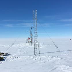
The Antarctic Automatic Weather Station (AWS) network has been making meteorological observations since the early 1980s. This continent-wide network is positioned to observe significant meteorological events and increase our understanding of the climate of the Antarctic surface. Researchers utilize the AWS network to observe and learn about the Antarctic in a warming world. Given the duration of the AWS program and maintaining AWS sites for many years, numerous studies have been conducted on the surface climatology of regions of the continent, such as the Ross Ice Shelf. This climatology also aids in other studies, like winter warming events.
The Antarctic Automatic Weather Station network provides a greater understanding of the surface meteorology and climatology throughout the continent of Antarctica. The AWS network spans the Ross Ice Shelf, Ross Island, West Antarctica, East Antarctica, and the South Pole. Since some of the AWS have been working for over 30 years, we can begin to understand the climate over many regions of Antarctica.
Expedition Map
IceCube and The Askaryan Radio Array 2018
What Are They Doing?
IceCube is located at the South Pole and records the interactions of a nearly massless sub-atomic messenger particle called the neutrino. IceCube searches for neutrinos from the most violent astrophysical sources: events like exploding stars, gamma ray bursts, and cataclysmic phenomena involving black holes and neutron stars. The IceCube Neutrino Observatory is a powerful tool to search for dark matter, and could reveal the new physical processes associated with the enigmatic origin of the highest energy particles in nature. In addition, IceCube studies the neutrinos themselves using the 100,000 neutrinos detected per year produced by cosmic rays in the atmosphere. Their energies far exceed those from accelerator beams. IceCube encompasses a cubic kilometer of instrumented ice, and is the largest detector by volume ever built.
The fully built ARA project, also located at the South Pole, will have an effective volume 100 times bigger than IceCube. The trade off is that it is only capable of observing radio waves from extremely high energy neutrinos, a million times more energetic than the neutrinos produced by cosmic rays in the atmosphere. This neutrinos are extremely rare, which is why such a large detector is needed to increase the chance of seeing one.
Expedition Map
Dry Valleys Ecosystem Study
What Are They Doing?
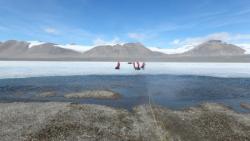
The McMurdo Dry Valleys Long-Term Ecological Research (MCM LTER) Program is an interdisciplinary and multidisciplinary study of the aquatic and terrestrial ecosystems in an ice-free region of Antarctica. MCM joined the National Science Foundation's LTER Network in 1993 and is funded through the Office of Polar Programs in six year funding periods. The McMurdo Dry Valleys (77°30'S 163°00'E) on the shore of McMurdo Sound, 2,200 miles (3,500 km) due south of New Zealand, form the largest relatively ice-free area (approximately 4,800 sq km) on the Antarctic continent. These ice-free areas of Antarctica display a sharp contrast to most other ecosystems in the world, which exist under far more moderate environmental conditions. The perennially ice-covered lakes, ephemeral streams and extensive areas of exposed soil within the McMurdo Dry Valleys are subject to low temperatures, limited precipitation and salt accumulation. The dry valleys represent a region where life approaches its environmental limits, and is an end-member in the spectrum of environments included in the LTER Network. The overarching goal of MCM LTER research is to document and understand how ecosystems respond to environmental changes.