Welcome to the Virtual Base Camp, the starting point for your exploration of the polar regions with PolarTREC teachers and researchers!
Expeditions
International Arctic Buoy Program
What Are They Doing?

Sarah and the team will be headed out for a second deployment to Thule, Greenland in June-July 2022.
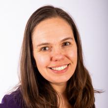
Carbondale, CO
United States
Expedition Map
Greenland Subglacial Tremor Project
What Are They Doing?

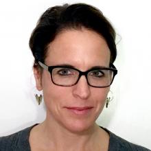
Auburn, ME
United States
Expedition Map
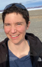
Investigating Ecosystem Carbon Response in Boreal Forests
What Are They Doing?


Anderson, AK
United States
Expedition Map
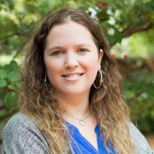
Effects of Lemmings on the Arctic Tundra Ecosystem
What Are They Doing?


Norway, ME
United States
Expedition Map
Harmful Algal Blooms in Arctic Waters
What Are They Doing?

At the same time, little is known about the present and future risk from toxic algae to humans in the Pacific Arctic region. This study will be the first to document the current distribution of highly toxic HAB species over large spatial scales within the Alaskan Arctic and will provide estimates of areas at high risk of toxicity now and in a warming future. The hypothesis underlying this project is that HABs in Alaskan Arctic waters are not only transported from the south through Bering Strait but are now originating locally on the Chukchi shelf due to warming temperatures, circulation dynamics, and water mass structure. These factors influence bloom magnitude, duration, toxicity, and recurrence. This will be addressed through a joint physical-biological field and laboratory program to study the relationship between HAB species distribution/dynamics and the physical environment of the Chukchi Sea region.
The distribution of HAB species on the Chukchi shelf will be mapped in relation to hydrography and circulation, including a comprehensive survey of the Alaskan Coastal Current which transports the warmest water in the Chukchi Sea. A range of molecular and physiological tools will be used to investigate the origin, connectivity, and fate of HAB populations in the region. Sediment profiling will establish a historical record of blooms along the major transport pathways to the western Arctic. This information will be used to generate conceptual models of the origin, transport, and fate of HABs in the Chukchi Sea region.
Brevig Mission, AK
United States
Expedition Map
Microbial Interactions in Antarctic Lakes
What Are They Doing?
Microbial communities are more than just a scientific curiosity. Microbes represent the single largest source of evolutionary and biochemical diversity on the planet. They are the major agents for cycling carbon, nitrogen, phosphorus, and other elements through the ecosystem. Despite their importance in ecosystem function, microbes are still generally overlooked in food web models and nutrient cycles.
Moreover, microbes do not live in isolation: their growth and metabolism are influenced by complex interactions with other microorganisms. This project will focus on the ecology, activity, and roles of microbial communities in Antarctic Lake ecosystems.

Lincoln, CA
United States
Expedition Map
Antarctic Automatic Weather Stations 2021
What Are They Doing?
, Antarctica. Photo by David Mikolajczyk, Courtesy of Michael Penn.")
The Antarctic Automatic Weather Station network provides a greater understanding of the surface meteorology and climatology throughout the continent of Antarctica. The AWS network spans the Ross Ice Shelf, Ross Island, West Antarctica, East Antarctica, and the South Pole. Since some of the AWS have been working for over 30 years, we can begin to understand the climate over many regions of Antarctica.
Springdale, AR
United States
Expedition Map
Dry Valleys Ecosystem Study 2022
What Are They Doing?

The McMurdo Dry Valleys (77°30'S 163°00'E) on the shore of McMurdo Sound, 2,200 miles (3,500 km) due south of New Zealand, form the largest relatively ice-free area (approximately 4,800 sq km) on the Antarctic continent. These ice-free areas of Antarctica display a sharp contrast to most other ecosystems in the world, which exist under far more moderate environmental conditions. The perennially ice-covered lakes, ephemeral streams and extensive areas of exposed soil within the McMurdo Dry Valleys are subject to low temperatures, limited precipitation and salt accumulation. The dry valleys represent a region where life approaches its environmental limits, and is an end-member in the spectrum of environments included in the LTER Network.
The overarching goal of MCM LTER research is to document and understand how ecosystems respond to environmental changes.
St. Louis, MO
United States
Expedition Map
IceCube and The Askaryan Radio Array 2022
What Are They Doing?
 hanging in the IceCube Lab at the Amundsen-Scott South Pole Station, Antarctica. Photo by Kate Miller.")
The IceCube Neutrino Observatory is a powerful tool to search for dark matter, and could reveal the new physical processes associated with the enigmatic origin of the highest energy particles in nature. In addition, IceCube studies the neutrinos themselves using the 100,000 neutrinos detected per year produced by cosmic rays in the atmosphere. Their energies far exceed those from accelerator beams. IceCube encompasses a cubic kilometer of instrumented ice, and is the largest detector by volume ever built.
The fully built ARA project, also located at the South Pole, will have an effective volume 100 times bigger than IceCube. The trade off is that it is only capable of observing radio waves from extremely high energy neutrinos, a million times more energetic than the neutrinos produced by cosmic rays in the atmosphere. This neutrinos are extremely rare, which is why such a large detector is needed to increase the chance of seeing one.

Los Angeles, CA
United States