Welcome to the Virtual Base Camp, the starting point for your exploration of the polar regions with PolarTREC teachers and researchers!
2015 Expedition Timeline
Expeditions
Antarctic Ice Stream Dynamics
What Are They Doing?

Expedition Map
US Arctic GEOTRACES
What Are They Doing?
Many trace elements are critical for marine life and therefore influence the functioning of ocean ecosystems and the global carbon cycle. Some trace elements are also of concern as contaminants, while others, together with a diverse array of isotopes, are used to assess modern-ocean processes and the role of the ocean in past climate change. Despite the recognised importance of trace elements and isotopes in the ocean, our ability to exploit knowledge of their attributes is limited by uncertainty about their sources, sinks, internal cycling and chemical speciation. GEOTRACES now fills this critical gap with knowledge of the marine biogeochemical cycles of trace elements and their isotopes at an unprecedented scale. Scientists from approximately 35 nations have been involved in the programme, which is designed to study all major ocean basins over the next decade. Much more information on details of the project can be found at the GEOTRACES website.
The GEOTRACES mission is as follows:
To identify processes and quantify fluxes that control the distributions of key trace elements and isotopes in the ocean, and to establish the sensitivity of these distributions to changing environmental conditions. We will do this by sampling the water column, sediments, sinking particles, atmospheric deposition, snow, and ice.
Expedition Map
Human Impacts in Antarctica 2015
What Are They Doing?

Humans have occupied the McMurdo Sound for over a hundred years. Early visitors had little impact on the region, but starting in the late 1950’s year-round, permanent buildings were established at McMurdo Station. Over the years thousands of humans have visited this area and have changed the landscape. Under its obligations to the Antarctic Treaty, the United States maintains a long-term monitoring program designed to track the environmental conditions in and around the station.
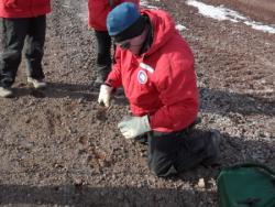
Each year, the research team conducts environmental monitoring and chemical, physical, and biological sampling in and around McMurdo Station. They collect samples from both marine and terrestrial habitats as measures of human impact. They take the samples back to the lab to look for contaminants.
The results of this research help document and minimize the impacts of future science and support operations in Antarctica. This information can be used to inform management decisions in and around McMurdo Station to help preserve the unique Antarctic environment.
Learn more about this project by visiting the official project website: Island to Ice.


