What Are They Doing?

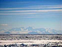
The goal of this project, funded by the National Science Foundation, was to broaden our knowledge of geology in this region with a new seismic array; the Transantarctic Mountains Northern Network (TAMNNET), a 15-station array across the northern TAMs and the WSB that helped fill a major gap in seismic coverage. Data from TAMNNET was be combined with that from previous and ongoing seismic initiatives and was analyzed to generate an image of the seismic structure beneath the TAMs and the WSB.
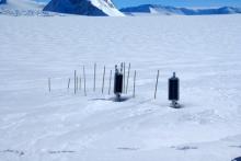
While in the field, the team spent most of their time servicing the seismic stations that compose the new TAMNNET array. This included loading equipment onto small airplanes, flying to remote field locations, uncovering the deployed equipment, and checking for any maintenance issues. The first batch of data from the network was also retrieved during this time.
Where Are They?

Latest Journals

Samantha Hansen is an assistant professor at the University of Alabama, where she researches fundamental earth science processes, such as mountain building, continental rifting, and craton formation. She employs a wide range of geophysical tools to analyze seismic data to investigate structure and infer associated geologic mechanisms. Over the past few years she has worked on several projects in Antarctica investigating the structure of the Transantarctic Mountains, the Gamburtsev Mountains, and the West Antarctic Rift System. She also has interests in earth science education and promoting underrepresented students in science. To read more about Dr. Hansen's work please visit her website.


