Ch-Ch-Ch-Ch-Changes
There are many challenges that present themselves when scientists are thinking about exploring Thwaites - both when you study the glacier from the land-side and when you approach the glacier from the water. No matter which way you come at it, it's Antarctica. It is cold. It is windy. It is remote. People have to stay warm, dry, and fed. Equipment needs to function, even when temperatures are many degrees below freezing. If something breaks, you hope you have someone on your team who is either a wizard or just really good at fixing things (we have Barry and Sheldon, who are a little bit of both) or you better have a back-up plan in place. There are no quick trips to the hardware store from the top or the foot of Thwaites.
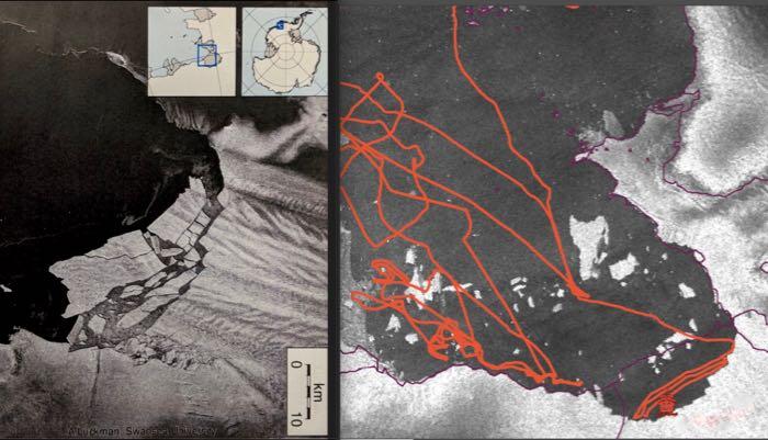
But with all due respect to the land-based Thwaites investigators (and much respect is due), their work site is relatively stable and unchanging, whereas ours moves and evolves all the time. Consider the image below. On February 11, the Pine Island Ice Shelf collapsed, leaving behind a number of new icebergs, the largest of which is close to 20 km (more than 12 miles) long - I shared the picture on the left with you last week. The image on the right has a little more information and includes updated satellite imagery we received this morning. The little red Boaty McBoatface in the lower right corner shows the current position of the R/V Nathaniel B. Palmer icebreaker. The zigzagging red line shows part of the path that the boat has followed over the past few weeks. The purple line shows what used to be the edge of the ice sheet. Can you find the position of the massive icebergs that calved off of the Pine Island GlacierA mass of ice that persists for many years and notably deforms and flows under the influence of gravity. just over a week ago? Remember that icebergs are constantly changing in shape and that the two photos are not presented at the exact same scale.

Winds and waves have shifted a lot of the ice away from Pine Island GlacierA mass of ice that persists for many years and notably deforms and flows under the influence of gravity.. This has allowed us to come right up to the edge of the PIG and spend 24 hours traveling back and forth along its face, mapping a seafloor that hasn't been accessible recently. But it also means that icebergs from Pine Island and from all the other glaciers in the area are preventing us from getting too close to the face of Thwaites, where we most want to explore. Chief Scientist Julia Wellner frequently discusses the situation with the ship's captain, trying to find the best compromise between his goal of keeping the ship and all its crew and passengers safe, and her goal of collecting the most relevant and important information about the Thwaites GlacierA mass of ice that persists for many years and notably deforms and flows under the influence of gravity.. We still have more than a month to go and it is likely the ice will continue to shift, so everyone is optimistic that we will be able to get closer. However, the Antarctic summer (such as it is) is drawing to a close, and it is only going to get more difficult to find ice-free areas close to the glacier's face.


Comments