Local Jokulls
Being part of this international research team is likely going to help me learn quite a bit about different Scandinavian cultures; the Icelandic culture being only one of them. Already my interactions with some of the research team members abroad are helping me learn a little bit of Icelandic. The Icelandic word for glacier is jokull, where the 'j' is pronounced as a 'y'. So Mulajokull in English is Mula GlacierA mass of ice that persists for many years and notably deforms and flows under the influence of gravity.. Whew, let's hope the rest of my encounters with the Icelandic language this summer go as smooth... Either way, I am very excited to finally meet the international members of the team and learn as much as I can from them during our time together both in and out of the field.
The research team is headed there this summer with one primary goal: determine the subglacial mechanisms responsible for the formation of drumlins at Mulajokull. These long, thin hills of glacial sediment (called till) are observed in many places across the world as a result of glacial processes throughout the last ice age in a geologic time period called the Pleistocene (approximately 2.5 million years ago - 10,000 years ago). Some of Earth's most beautiful and spectacular landscapes are the result of glacial erosion and depositional processes from the Pleistocene, especially in the northern hemisphere.

While glaciologists and geomorphologists (scientists that study processes that alter Earth's surface by creating new landforms) have observed and measured many modern glaciers scouring and changing Earth's surface in the same ways that Pleistocene glaciers did, the drumlin has remained as a sort of glacial enigma to this branch of the scientific community.
You see, unlike more common glacial landforms such as moraines, cirques, and outwash plains, until recently drumlins have never been observed during their active process of formation. Up until 2009, the only field observations recorded about drumlins are from drumlin fields that originate from the Pleistocene.

The mystery of these landforms, however, has been slowly becoming more and more understood now that scientists have discovered the first known active drumlin field on the planet since the end of the Pleistocene ice ages nearly 10,000 years ago.
One of the most common and easily observed effects of increased global surface temperatures since the start of the Industrial Revolution is the decline in the mass balance of the world's glaciers. Mass balance is a measurement that scientists use to determine a glacier's gain or loss of snow and ice during a certain time period of time. It is calculated by finding the difference between a glacier's accumulation (gain of snow/ice) and a glacier's ablation (loss of snow/ice). Analysis of mass balance observations over the last century, along with qualitative photographic observations like the one below, have led scientists across the globe to conclude that, with very few exceptions, the earth's glaciers are decreasing in size and shrinking at unprecedented rates.

Mulajokull is not one of the exceptions to the observed trend in worldwide glacial retreat, hence the research team's expedition to its drumlin field this summer. If not for the effects of climate change on glacial mass balance, the drumlin field at Mulajokull may never have been exposed over the last few years.

Glaciers 101: What exactly is a glacier?
Over the next few weeks of journaling, we are going to dive deeper into Dr. Iverson's and Dr. Hooyer's goals and experimental design for the project at Mulajokull. But first, I think it will be beneficial for followers of our expedition to learn a little bit of background information about glaciers as a whole.

The word glacier is French for 'ice'. Which is exactly what they are: ice. Not just any ice though. Their formation, behaviors, and ability to flow/move make glaciers quite different from the typical ice you make in your freezer at home. Ice in your freezer is brittle Here's the deal:
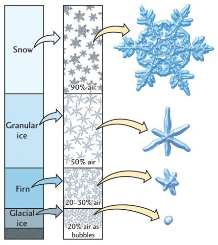
GlacierA mass of ice that persists for many years and notably deforms and flows under the influence of gravity. ice can range from hundreds of years old to many hundreds of thousands of years old, and forms as a result of annual snowpack surviving through a season of melting, only to be further buried by another year's snowpack. This continual burial process increases overlying pressure on the snow crystals below, causing them to deform and recrystalize; eventually turning into glacial ice. This newly formed ice behaves as a pseudoplastic material and can deform into various shapes; unlike the more familiar brittle ice in your freezer. Two essential criteria must be met for ice to be classified as a glacier:
- it must form due to the accumulation and recrystallization of snow over land, and,
- it must move across Earth's surface either by internal flow or basal slippage (sliding at its base), both a result of gravity pulling down on the ice.
The Extreme Ice Survey has released some AWESOME time-lapse videos of the world's glaciers, giving excellent examples of their pseudoplastic behvaior.
Glaciers are part of the cryosphere (the portion of the earth's systems that exists as frozen water) and cover approximately 10% of all land surfaces on the planet. According to the National Snow and Ice Data Center, when looking at all of the freshwater water on Earth, approximately 75% of it is currently stored in glacial ice.
There are two primary types of glaciers: alpine/valley glaciers, and ice sheet/continental glaciers. Each type scours and erodes Earth's surface acting as enormous conveyor belts of sediment and debris through the processes of abrasion and plucking. In warmer seasons, glacial ice melts and seeps into surrounding bedrock. During colder seasons, this water refreezes and expands, thereby pushing/plucking pieces of bedrock out and engulfing them into the body of the glacier.

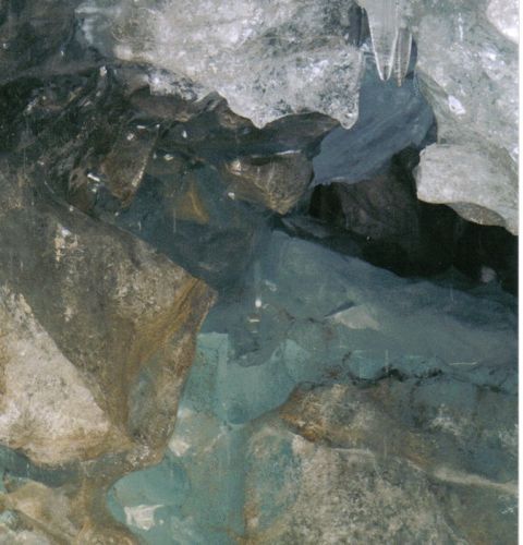
These processes are capable of moving rocks ranging from silt-sized till, to the giant glacial erratic-sized till.

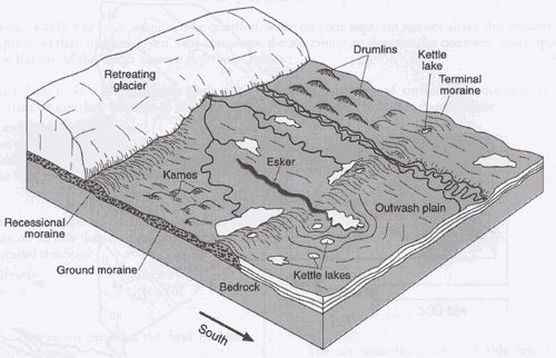
Valley glaciers are, or have been, common in the Rocky Mountains, Alaska, and the European Alps. They act like long tongues of flowing ice and carve characteristic U-shaped valleys into Earth's surface as they advance. These U-Shaped valleys are left mostly in tact once an alpine glacier has retreated, along with landforms like moraines, horns, cirques, outwash plains, and hanging valleys.


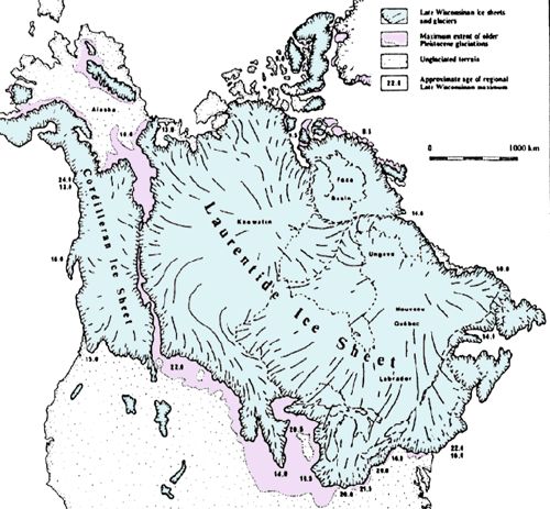
Continental glaciers are more common in places like Greenland, Antarctica, and Iceland. These glaciers are not confined into valleys in mountainous terrain, and instead spread out over vast distances flowing relatively equally out in all directions from a common center point. These are the types of glaciers that dominated the northern hemisphere throughout the Pleistocene with well-known ice sheets like the Laurentide and Cordilleran here in North America. Continental glaciers also leave depositional landforms such as moraines and outwash plains as they retreat, however, they leave behind a few depositional landforms that valley glaciers do not: drumlins being one of them.
Meet Mulajokull
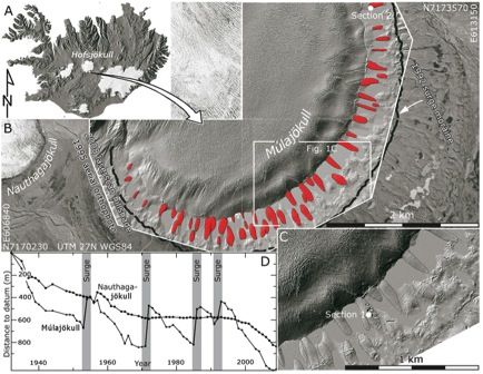
The glacier Mulajokull is a surge type glacier that extends off of the southeast portion of the Hofsjokull Ice Sheet in Central Iceland. Surge glaciers like Mulajokull are characterized by rapid rates of advance and retreat, nearly 100 times faster when compared to other glaciers. Basal slippage is the best current explanation for what causes such rapid movement of surge glaciers. This can occur when water gradually accumulates within interconnected cavities at the base of a glacier, causing a hydraulic pressure to build up to the point where the ice is actually raised a bit (less than a few centimeters) off of the underlying bedrock. This thereby decreases the static friction between the ice and the bedrock, allowing the glacier to accelerate and move faster due to the force of gravity.
Surges at Mulajokull have been recorded going back to 1924, occurring approximately every 10-20 years. The most recent surge occurred in 1992 (Bjornsson et al., 2003), and the glacier experiences an increase in ice-margin of 200-400 meters with each surge. Presently, Mulajokull is experiencing significant retreat, and has yet to surge past its furthest surge moraine dating back to around 1900, at the end of the Little Ice Age in Iceland.
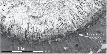
The 7-km-long ice-margin of Mulajokull is home to a drumlin field consisting of about 50 drumlins, ranging from 90-320 in length, 30-105 m in width, and 5-10 m in height (Johnson et al., 2010). Each drumlin is separated from the next by a series of small lakes, and radiate out from the glacier in approximately 180˚.


Why Mulajokull?
As previously stated, Mulajokull is home to the only known active drumlin field on the planet, and while drumlins are some of the most widely studied glacial landforms, finding them in a state of active formation has been nonexistent until the recent 2009 discovery of this drumlin field at Mulajokull. Also, the drumlins of Mulajokull are a perfect match to the well-known dimensions of Pleistocene drumlins across North America and Europe, and are now providing the scientific community with an excellent analog to how these landforms may have formed tens of thousands of years ago. Think of the drumlin field at Mulajokull as a sort of time machine, allowing scientists to see how large ice sheets of the Pleistocene likely behaved tens of thousands of years ago.
With nearly all of the glaciers on the planet presently retreating due to climate change and warming land surface temperatures, Mulajokull may soon enough not be the only active drumlin field around. By testing their hypotheses for how these drumlins form, and why Mulajokull is creating them, Dr. Iverson and Dr. Hooyer will gain valuable insight into the basal drag mechanics of glacial movement, helping scientists uncover even more knowledge about how glaciers have operated in the past, currently operate in the present, and may continue to operate in the future. With the possibility that drumlin fields could become more widespread on Earth due to climate change and the recession of the glaciers, understanding drumlin and what they can tell us about Earth's systems may become increasingly important as time goes on.

Stay tuned for the next journal about the environment and summer climate near Mulajokull. I'll also show you the gear I am bringing along to prepare for the elements while I am there. Don't forget to sign-up for a subscription to the journal feed and receive an email each time I upload content!
Cheers, Jamie


Comments