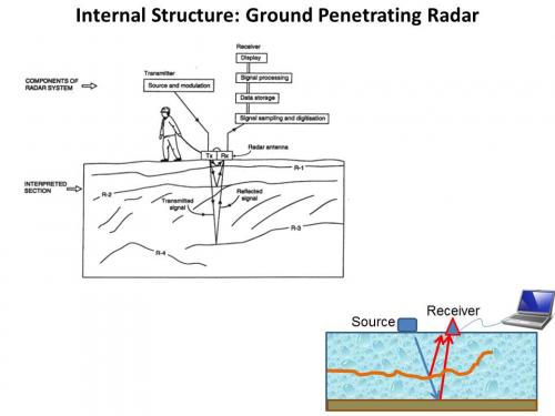
Ground Penetrating RadarA method of estimating the distance or travel speed of an object by bouncing high frequency signals off the object and measuring the reflected signal. (GPR) is one of the instruments being used during the 2012 season to determine the presence and depth of buried ice in areas of the Dry Valleys.

What is Ground Penetrating RadarA method of estimating the distance or travel speed of an object by bouncing high frequency signals off the object and measuring the reflected signal. (GPR)?
GPR is a geophysical technique that collects and records information about the subsurface without digging it up. GPR can detect underground water, rock structure, buried ruins and many other types of objects. A radio wave signal is shot directly at the ground by a transmitting antenna. This signal will travel through the ground until the material properties of the earth changes. When it comes across a different sort of object, some of the signal passes on and some of it is reflected back to a receiving antenna. The reflective portion is what is being measured. When the signal is reflected back, a computer measures how long it took to make the trip there and back. From this, the computer calculates how deep the buried object or change in underground material is. The GPR machine will be dragged back and forth over the ground, making thousands of measurements in an area. A computer puts these together to make a 2D model of the objects buried under the ground.

Watch the video below to see Jackie and Sean using GPR in Upper Beacon Valley Antarctica. Notice the sound of the wind in Beacon Valley.
http://youtu.be/eYHH5unyTXg
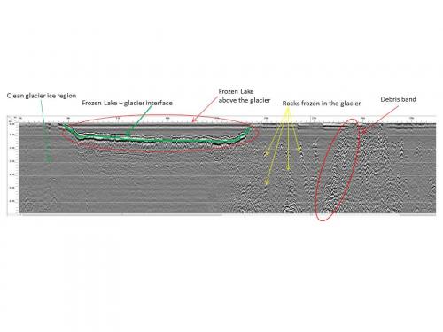
The printout below was supplied by Sean Mackay and illustrates the features interpreted from GPR data near the headwall of Mullins GlacierA mass of ice that persists for many years and notably deforms and flows under the influence of gravity..

A similar GPR technique using a radar instrument called the Mars SHAllow RADar sounder (SHARAD) is being used for subsurface investigations on Mars. SHARAD can identify liquid or frozen water in the first few hundreds of feet (up to 1 kilometer) of Mars' crust. Water, like high-density rock, is very conducting, and will have a very strong radar return. SHARAD probes the subsurface from the Mars Reconnaissance Orbiter using radar waves within a 15- to 25-megahertz frequency band to get the desired, high-depth penetration. In certain areas, radar properties are consistent with massive sub-surface water ice, and the results imply that these glaciers formed in a previous climate conducive to glaciation at middle latitudes.


Comments