Cruise Day 27
Speed 6 knots (kts)
Course 28° (NNE)
Location Lomonosov Ridge, approx. 42nm S. of the North Pole
Depth 2728 m
GO DEEPER DISCUSSION: (see previous journal for the questions.)
Lines of longitude all meet at the poles, so as we get closer and closer to the North Pole there’s less and less distance between each degree of longitude. This lets us change our longitude very quickly now. Latitude lines are parallel, and so every degree of latitude is the same distance from the next across the entire Earth (60 nautical miles.)
TODAY’S JOURNAL:
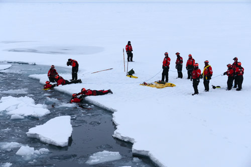
As we were heading north last night, the crew found a large unbroken piece of thick ice and parked the Healy by crunching the bow into it. The science team had been wanting to do a sampling station on the ice for quite a while, but the ice we had encountered until last night wasn’t deemed safe enough to put a large group of people out onto. Most of what we have been seeing in the ice department has been too thin, too rotten, or broken into pieces too small for an ice station (the same reasons we have been making good time.) But at about 10 pm, a team of three Coast Guard crew members with dry suits set out to test the ice in an area about the size of a football field. Once it was determined to be safe, the Coast Guard conducted ice rescue training and practice in the open water Healy left behind. Then, the green light was given for our ice sampling station to begin.

We reached the ice by descending a long steep gangway known as a brow. The brow doesn’t have steps- rather, it has a grippy surface like a giant cheese grater or woodworking rasp. It wouldn’t be too bad in sneakers or hiking boots, but it was tricky to mince my way down dressed up in a stiff Mustang survival suit and ice boots. This was the first time off the ship for us since leaving Dutch Harbor on 9 August. Several teams had different goals on the ice. One team drilled through the ice to sample seawater and ice for trace metals and so had to follow very clean collection protocols. They kept the farthest away, and upwind from the ship to avoid contamination. Other scientists were looking for plankton under the ice or took snow samples for radioactive isotope analysis. I spent most of my time with the beryllium pumping group.

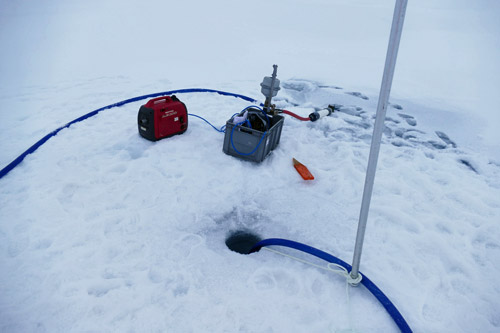
The process for filtering beryllium on ice follows the same general pattern as when it is done on board (Pumping Beryllium journal), with some modifications appropriate to the setting. On the ice, the team begins by drilling a hole with a power auger. For ship-based sampling, the beryllium team already has CTDA research tool that is submerged in the water to measure conductivity (salinity), temperature, and depth. data from prior casts to base their sampling depths on. Lacking that on the ice, they start with a CTDA research tool that is submerged in the water to measure conductivity (salinity), temperature, and depth. cast using a portable battery-powered unit that is lowered by hand into the ocean on a line. This CTDA research tool that is submerged in the water to measure conductivity (salinity), temperature, and depth. doesn’t communicate with the surface, instead recording water profile data as it goes down and then back up. The team then connects the CTDA research tool that is submerged in the water to measure conductivity (salinity), temperature, and depth. to a laptop to see what’s going on in the sub-ice water column, picking their sampling depths. A hose is connected to the CTDA research tool that is submerged in the water to measure conductivity (salinity), temperature, and depth. housing and both are lowered to the first selected sampling depth. Then, a gas generator-powered pump brings up water that runs through the same filtering units that are used on the ship. There are no tanks filled on the ice; instead, the water is just pumped straight through the filter canister. The filtered water then runs onto the ice, soaking into the snow to either drain through cracks or re-freeze. When 700 liters of water have been pumped through the filter, the hose intake and CTDA research tool that is submerged in the water to measure conductivity (salinity), temperature, and depth. are lowered to the next level, a new filtering canister is installed, and the process repeated until the group has the samples they are interested in. Last night, this process took from about midnight to nearly 8am.


It was a pretty neat experience to go for a stroll on the surface of the Arctic Ocean. Even crazier was realizing that we were standing over the Makarov Basin’s abyssal plain in water nearly 2.5 miles deep! Hopefully we’ll get more chances to have time out on the ice in the weeks to come before we get too far south for safe ice. For now, we are heading north with almost astonishing speed, traveling at 6 or 7 knots despite being above the 89° parallel. At this rate the North Pole is only hours away!

GO DEEPER!
There was a little over ten centimeters of space between the top of the ice and the water line in the hole we drilled through the ice. Why didn’t the water come to the top of the hole, and how can you estimate the total thickness of the ice from this measurement?
Aloft Con web cam updated every hour
Healy Track
That's all for now. Best- Bill


Comments