Unexpected Mission

    If you are using the map tab at the top of the journal page, you may notice that we have made a slight turn to the west instead of continuing NE towards the Le Maire Strait (in southern Argentina). Last evening, we received a request from the National Science Foundation (NSF) to adjust our course in order to recover a disabled underwater glider. An image of one type of underwater glider is shown on the Woods Hole Oceanographic Instititution information page on gliders. The gliders are autonomous underwater vehicles (AUVs) that are programmed to record information such as salinity, temperature, currents, chlorophyll levels, etc. The autonomous nature of these gliders allows them to collect large quantities of data over long periods of time. The glider in question has not been working properly for some time, therefore, a request was made to collect the glider from the Drake PassageStrait, connecting the Atlantic and Pacific oceans between Tierra del Fuego and the South Shetland Islands. Located about 100 mi (160 km) north of the Antarctic Peninsula, it is 600 mi (1,000 km) wide. and return it to port for maintenance/data recovery. After about two hours of searching, we located the glider around 1000. Look at the picture below to see why it took some time to find.
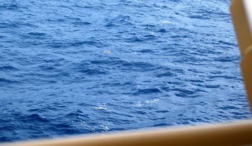
    Glider in open ocean
    The small, yellow underwater glider is difficult to find in the open ocean. The rails of the ship help provide perspective on the small object in the vast ocean.

    Permission was required to bring the equipment aboard the vessel. The glider was located in a position within the Chilian Exclusive Economic Zone (EEZ). These zones generally extend to approximately 200 nautical miles from land. EEZs were established under the United Nations Convention on the Laws of the Sea (1994). Under these laws, EEZs were established to provide nations with the exclusive rights to these areas. This includes marine scientific research. Permission was granted around 1200 and the glider was on deck by 1230. We resumed our course soon after. Tomorrow, we should reach the Le Maire Strait and, in another day and a half (or so), reach the dock in Punta Arenas, Chile.
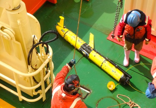
    Glider on deck
    The underwater glider was grappled and craned on deck. Before the glider was brought on deck, many noticed the glider was missing a wing. Normally, there are two wings, just like an airplane.

    Packing Update

    The packing process is in full swing on the RVIB Palmer. Equipment must be cleaned, inventoried and stowed for shipment. The science team must account for everything that was originally brought aboard the ship. If they brought it, it must either be part of the return shipment, part of the recorded chemical waste, part of the sample shipments, or part of the general waste. With four different lab groups occupying the same lab spaces for the past 5 weeks, materials are all over the place. The teams are working hard to ensure paperwork is correct and materials are secured for shipment before we reach port late Friday/early Saturday.

    Zodiac Ops

    My time aboard the RVIB Palmer has been full of learning opportunities and new experiences. I have documented most of these experiences as they happen (or just a few days after). There is one experience, however, that I decided to save for one of my last journals. This experience will forever be one of the most amazing experiences of my life. In late September, while sampling seawater in Duse Bay (in the Bransfield Strait), we had the opportunity to board the small boats (Zodiacs) in order to collect ice samples. I mentioned collecting ice samples in last Saturday's journal, but there were definitely some differences between the two operations.

    In last Saturday's ice collection operation, the ice was collected specifically in locations with sea-ice algae. The collection in Duse Bay was done specifically to collect ice from a region near land. In a number of previous journals, I have mentioned the low levels of iron in the Southern Ocean. The main areas where higher iron levels are detected are in coastal regions. This is because of the sediment that enters the water from the land.
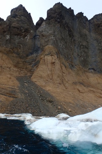
    Iron sediment
    The fast ice gleams white below the sediment filled cliffs. The rusty color of the sediment indicate the presence of iron. As the sediment mixes with the ocean water, iron levels increase in the area.

    The second difference between the sampling in Duse Bay and the ice sampling from this past weekend is that I was directly a part of the process. Selfish...yes. Sorry...no. To collect the sediment-filled ice, the science team boarded small rigid inflatable boats or RIBs (often referred to as a Zodiacs because of the manufacturing company) to get as close to the ice along the shore as possible. The night before the small boat operations, science team members attended a training session on the main deck.
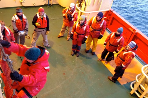
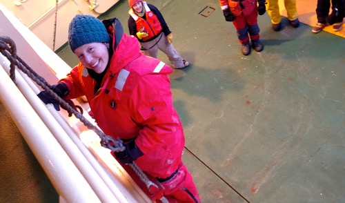
    Jacob's ladder training
    Members of small boat 1 watch Cara Pekarcik participate a practice climb of the Jacob's ladder. Every member of the team practiced climbing the ladder in preparation for Zodiac deployment the following day. Photo courtesy Kimberly Powell.

    Top of the ladder
    Cara Pekarcik reaches the top of the Jacob's ladder during small boat operations training on the Nathaniel B. Palmer. Photo courtesy Kimberly Powell.

    I was assigned to Small Boat #1 along with the ice collection science team and Marine Technicians Holly Martin and Jullie Jackson.
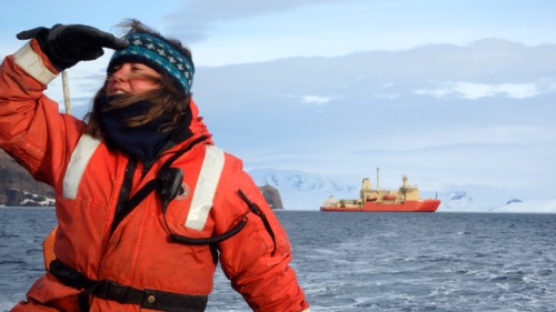
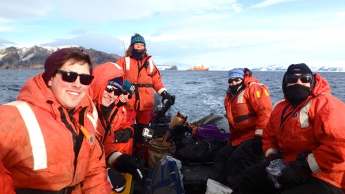
    Captain Holly
    Marine Technician Holly Martin strikes a stoic pose as she steers the Zodiac towards the fast ice. The Nathaniel B. Palmer looks small from this distance - not easy for a 308 foot ship.

    Small boat 1 team
    Some of the crew from small boat one (from left): Kris Gomes (URI), Sveinn Einarsson (ODU), Cara Pekarcik, MT Holly Martin, Dr. Dreux Chappell (ODU) and Dr. Bethany Jenkins (URI).

    We left just after breakfast. The weather was great - light winds and calm seas. We sampled ice from the shores a few miles from the RVIB Palmer. We were right up against the fast ice (ice that is still attached to land). From a distance, this ice appears as a thin layer. Close up, the ice was at least 1-2 feet thick (sometimes more). Being close to the water provided a completely different perspective of the water, the ice and the surroundings. The collected ice was bagged and stowed for the ride back to the ship.
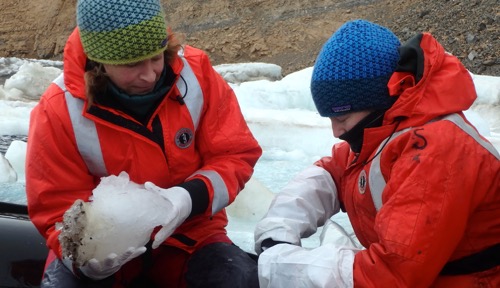
    Ice chunk with sediment
    Dr. Kristen Buck (left) hands Dr. Randie Bundy a large chunk of ice removed from the fast ice. The dark spots on the left of the ice are the sediment deposits from land. These sediments contain trace metals like iron.

    Consolation Prize(s)

    During our sampling, the winds picked up and small waves filled the bay. This made for a wet, bumpy ride back to the RVIB Palmer. No one made it back to the ship without a good dousing (or two, or three, or many) of water from the waves. Our consolation? First, ice samples that will allow the trace metal team to analyze isotopic signatures from land. This type of sampling is very rare in this area. Understanding more about the isotope signatures can help scientists understand how the metals and other nutrients from land are influencing the waters in the area. The second consolation came in the form of our seal sightings. The Duse Bay area contained a large amount of fast ice - a perfect location for resting seals. Hundreds of crabeater seals were resting on the fast ice in the bay. While aboard the small boat, we had a eye-level view of these seals. At our closet point to the ice, Dr. Kristen Buck was busy sampling the ice and many of us were busy taking photos of the seals.

    Crabeater seals at eye level
    Crabeater seals relaxed on the fast ice and small boat one moved towards the sediment covered ice ahead. This area in Duse Bay appeared to be a resting place for hundreds of these seals.
    Sveinn Einarsson from Old Dominion University randomly stuck his GoPro camera in the water during the ice sampling operation. It was not until we returned to the ship, dried off and warmed up that we were all amazed by the underwater shot. A special thanks to Sveinn for allowing me to post this video. My GoPro was on my head, so I wasn't able to get any underwater shots :). The following video is very quick, but amazing. Enjoy!

    Author
    Date
    Location
    Drake Passage
    Weather Summary
    Mostly cloudy with a few scattered rain showers
    Temperature
    4C/38F
    Wind Speed
    10-15 knots
    Wind Chill
    -5C/23F

    Comments

    Adina Dildine

    Congratulations on your Zodiac ride and the successful expedition! I'm curious: how close were you to the crabeater seals on the fast ice and swimming below? Also, do they vocalize? Enjoy the rest of your journey!

    Cara Pekarcik

    Hi Adina - thanks for the question. We were never right next to the seals (unless they were below the boat and we didn't know). When they
    were underwater, I think they were about 15-20 feet from the boat. The
    distance was a little greater when they were on the ice and we were on
    the boat. We were aware of our distance during the entire operation so
    that our presence did not cause a disturbance for the wild animals. I
    have not been able to find specific information on vocalization studies
    in crabeater seals, however, I can tell you that we did hear them
    produce sounds. Something similar to a bark.

    On 2016-10-13 04:56, PolarTREC wrote:

    cara lew

    why did you have to collect ice in specific locations?

    Cara Pekarcik

    Hi Cara - as I think I described in the journals, ice was collected in certain spots in order to collect either sediment samples or to collect
    sea-ice diatoms.

    On 10/18/16 4:31 PM, PolarTREC wrote:

    Sam

    What was your favorite location throughout your travels? Would you ever want to go back?

    Raymond Chin

    Hello Ms. Pekarcik!
    About the Laws of the Sea regarding the EEZ, is this law protecting a certain species or is it there for the sole purpose of research?

    Daniel J-T, block E

    about how many of these gliders are used to provide information about the sea?

    SheilaB Block E

    Do the seals usually come back to the same resting area or is it a one-time stop?

    SheilaB

    I forgot to ask- do you know If there are seals near the boat? Do you know if there was a possibility of you hitting one?

    Marvisa

    Hello Ms. Pekarcik, What would make the glider stop working? Did that mess up with the data collected in any way?

    Marvisa

    Hello Ms. Pekarcik, What would make the glider stop working? Did that mess up with the data collected in any way?

    Cara Pekarcik

    Marisa - I am sure there are a number of different scenarios that could make a glider stop working (just like a satellite, Internet modem, or any other electronic equipment).  I do not know if it affected the data in any way because the glider belongs to scientists that were not on the ship.  We were just in the area and were asked to collect the glider.

    From: PolarTREC
    To:
    Sent: 10/20/2016 7:10 AM
    Subject: Re: Marvisa commented on 12 October 2016 Small Boat Ops

    ((

    Cara Pekarcik

    Sheila - if you look at the pictures and images, you can see that there were seals fairly close to the boat.  If they were in the water near the boat, we were not really aware.  We did keep our distance from the seals on land.  I would assume the seals would stay away from the boat.

    From: PolarTREC
    To:
    Sent: 10/20/2016 7:10 AM
    Subject: Re: SheilaB commented on 12 October 2016 Small Boat Ops

    (((

    Cara Pekarcik

    Sheila - I am not sure - I do not know if there is any photo-id work or tag work on the seals in this area to determine if they return to the same area.

    From: PolarTREC
    To:
    Sent: 10/20/2016 7:08 AM
    Subject: Re: SheilaB Block E commented on 12 October 2016 Small Boat Ops

    Cara Pekarcik

    I do not know the answer to this question.  You can check out the link to the WHOI site to learn more about the gliders.  They are sent out in groups to travel to various locations based on the research questions.  There are a number of different types.

    From: PolarTREC
    To:
    Sent: 10/20/2016 7:05 AM
    Subject: Re: Daniel J-T, block E commented on 12 October 2016 Small Boat Ops

    (((

    Cara Pekarcik

    The EEZ is not for a specific species.  The EEZ is in place to protect the rights of the nearby countries to utilize their coastal areas.

    From: PolarTREC
    To:
    Sent: 10/20/2016 7:02 AM
    Subject: Re: Raymond Chin commented on 12 October 2016 Small Boat Ops

    (

    Cara Pekarcik

    I would return in a heartbeat! I enjoyed Duse Bay and the Gerlache Strait

    From: PolarTREC
    To:
    Sent: 10/20/2016 6:52 AM
    Subject: Re: Sam commented on 12 October 2016 Small Boat Ops

    Aidan Ring

    Was it difficult to navigate the RIBs to the ice?

    Cara Pekarcik

    Aidan - I was not responsible for driving the RIB. The RIB is propelled by a small outboard engine.  Anyone who drives the RIB must complete a safety training before doing so.

    From: PolarTREC
    To:
    Sent: 10/21/2016 5:45 PM
    Subject: Re: Aidan Ring commented on 12 October 2016 Small Boat Ops

    ((