Science Update

    The science team has been working non-stop for the past few days. Between wrapping up the first incubation experiment, moving ahead with the next two incubation experiments, setting up individual experiments and station sampling along the Palmer LTER, every member of the science team has been working long hours. Today, we didn't start sampling until after breakfast. This gave most a chance to sleep a bit and to head to the bridge to check out some of the amazing scenery (see below). After spending a few days offshore in the Drake PassageStrait, connecting the Atlantic and Pacific oceans between Tierra del Fuego and the South Shetland Islands. Located about 100 mi (160 km) north of the Antarctic Peninsula, it is 600 mi (1,000 km) wide., we were happy to move closer to land.

    Ice From Above

    Rain early in the evening followed by snow overnight created a coating of ice on most of the decks of the RVIB Palmer. The exception, however, is the main deck. This deck is heated to allow for safe operations on deck. Other locations of the ship that are coated in ice require care when walking or even standing. One major safety concern is ice falling from above. With sunny conditions throughout the morning and afternoon, many people headed to the decks for pictures. You must always look up to be sure you are in a safe location. During CTDA research tool that is submerged in the water to measure conductivity (salinity), temperature, and depth. deployments, you are sometimes required to stand in a particular spot. In these situations, hard hats are an important piece of on-deck safety equipment.
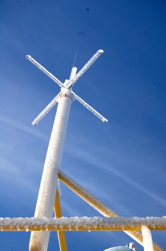
    Iced equipment
    Ice coats the railings, antennas and other equipment outside the bridge of the RVIB Palmer. These ice pieces would fall approximately 80 feet before they hit the water.

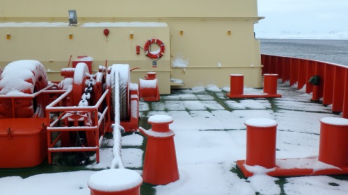
    Snow on deck
    A night of rain and snow left an inch or two of slush on the bow of the ship. After the sun broke through the clouds, most of the snow disappeared.

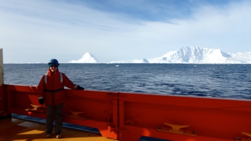
    Hard hat area
    Cara Pekarcik dresses in deck safety gear for CTD deployments. This gear includes a bright orange 'float coat', steel-toed rubber boots and a hard hat. Sunglasses were also important on this sunny day.

    Gerlache Strait and Wilhelmina Bay

    After sampling a Palmer LTER station in the southern Drake PassageStrait, connecting the Atlantic and Pacific oceans between Tierra del Fuego and the South Shetland Islands. Located about 100 mi (160 km) north of the Antarctic Peninsula, it is 600 mi (1,000 km) wide., we left the Drake PassageStrait, connecting the Atlantic and Pacific oceans between Tierra del Fuego and the South Shetland Islands. Located about 100 mi (160 km) north of the Antarctic Peninsula, it is 600 mi (1,000 km) wide. and headed toward sampling stations in more protected regions closer to land. Overnight, we entered the Gerlache Strait, a well-known body of water separating the Palmer ArchipelagoA chain of many islands. from the continental Western Antarctic Peninsula.
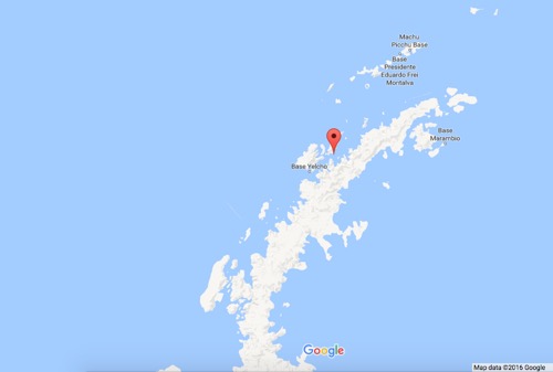
    Google Map of Antarctic Peninsula
    Gerlache Strait is shown on the map with the red marker. This strait separates the Palmer Archipelago from the continental portion of the Western Antarctic Peninsula. Brabant Island is directly underneath the red marker. Map data ©2016 Google

    The Gerlache Strait was first explored between January and February 1898 during an expedition led by Lt. Adrien de Gerlache. Gerlache originally named the body of water Belgica after the expedition ship, but the name was later changed to honor the leader. This area is known for its beauty and for numerous wildlife sightings.
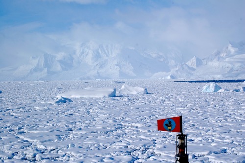
    Ice in the Gerlache Strait
    The Gerlache Strait is known for beautiful scenery. This area is often filled with ice, as seen in this photo. For scale, the 'flag' is approximately 70ft off the waterline.

    After sampling off the coast of Brabant Island (just under the red marker on the map), we continued to travel in a southwesterly direction to a narrow section of the strait. We turned to port and entered Wilhelmina Bay. I have one word for this location - BREATHTAKING! Wilhelmina Bay was named by Gerlache after the Queen of the Netherlands. It is a large bay surrounded by tall peaks and filled with ice. For many, this was our first opportunity to see the peninsula. This peninsula, while only a small portion of the continent, represents the entire land mass of Antarctica. We are looking at the tip of the 14.0 million square kilometer (5.4 million square mile) coldest continent on Earth. I don't know if I can speak for everyone aboard, but it is a special moment for me - a realization of a dream. I wake up every day and can't believe that I am here. I have one word for this entire experience - AMAZING!
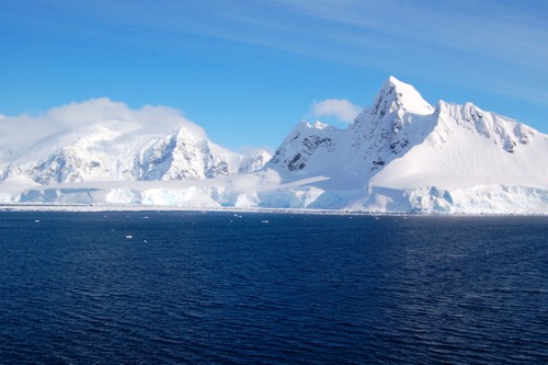
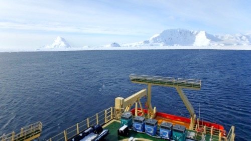
    Mountains of Emma Island
    Snow and ice covered land masses dominate the landscape of Emma Island. This island is located at the mouth of Wilhelmina Bay.

    Wilhelmina Bay overlook
    A view of Wilhelmina Bay from the 05 deck or bridge deck, looking aft (towards the back of the ship).

    After another set of CTDA research tool that is submerged in the water to measure conductivity (salinity), temperature, and depth. casts to sample the Palmer LTER station in Wilhelmina Bay, we will head back to the Gerlache for the night and continue to navigate the Gerlache Strait to other sampling stations.

    Author
    Date
    Weather Summary
    Rain turned to snow overnight, bright and sunny during the day
    Temperature
    1C/34F
    Wind Speed
    25-30 knots
    Wind Chill
    -16C/3F

    Comments

    Anastasia Z, Block B

    Hello, Mrs. Pekarcik. I noticed that you include the wind speed above and was wondering if a knot was faster than mph and if it effects the speed at which moves when it floats on the water?

    Cara Pekarcik

    Hi Anastasia - great question! One knot is about 1.15 mph. I think there are a few words missing from your second question, but I am going
    to assume that you are asking about the boat's speed (if not, hit reply
    and let me know). The wind can affect the speed of the vessel if it is
    creating large waves that may force the ship to reduce speed. We have
    had speeds of up to 60 knots and the vessel was able to maintain her
    position. I think being on such a large vessel certainly helps. If we
    were on a small boat, it could definitely make a difference.

    On 2016-09-29 14:33, PolarTREC wrote:

    Vivian Tran

    Hi Mrs. Pekarcik. I noticed that there is a lot of snow and frost covering the antennas. Does this affect the connection between the ship and the internet?

    Andrew Tobin

    On your journey, will you and the crew be docking at any research stations if any are in the vicinity?

    Danny F, Block A

    Hi Ms. Pekarcik,What is the warmest it has been in Antarctica so far on your expedition?

    James

    Hi, Mrs. Pekarcik i would like to know if the icy weather can cause damage to the ship and the engine?

    Jake O Block A

    Hi Ms. Pekarcik,Sorry if this got posted twice but I was wondering if it is still "fall" in Antarctica? Also about how much snow is currently in Antarctica?

    Aidan Ring Block A

    What is the significance of sampling the Palmer LTER stations?

    Kevin Lin Block A

    You said that the Gerlache Strait is known for its numerous wild life sightings. During that night have you seen any wild life?

    Cara Pekarcik

    Hi Kevin - It is pitch black here at night. If any wildlife was in the area, it would have to be directly off the front of the ship for the
    spotlight to pick it up. The sun is rising earlier and setting later
    each day which gives us more opportunity to see wildlife.

    On 2016-09-30 07:08, PolarTREC wrote:

    Cara Pekarcik

    Hi Aidan - head back to the journal title Palmer LTER to find out more about this important sampling area

    On 2016-09-30 07:06, PolarTREC wrote:

    Cara Pekarcik

    Very large pieces of ice might cause damage if we were to hit them, but the vessel is made to break ice (it has a reinforced hull), so these
    pieces that were seeing do not cause any damage. The engine is inside
    the vessel.

    On 2016-09-30 07:00, PolarTREC wrote:

    Cara Pekarcik

    Yesterday (9/29) was a very warm day. We had clear skies and lots of sunshine. The temperature rose to about 3C/37F with little wind. The
    wind picked up later in the day, so it didn't stay very warm for long.

    On 2016-09-30 06:58, PolarTREC wrote:

    Cara Pekarcik

    We do not have a research station in the plans. This is a boat-based research project.

    On 2016-09-30 06:45, PolarTREC wrote:

    Cara Pekarcik

    Hi Vivian - that antenna was just a GPS antenna, so not in this case. The antennas are still able to send out the radio waves or other types
    of signals necessary.

    On 2016-09-30 06:38, PolarTREC wrote:

    Hannah Gray

    You mentioned in the Ice From Above section that the main deck is heated for safety, but that it is the only area on the boat to have such heating. If that's the case, what precautions does the crew have to take in the cabins and other off duty times to stay safe?

    Cara Pekarcik

    Hi Hannah - thank you for the question. My apologies - I should clarify. The main deck is the only location that has deck heating. The
    inside of the ship has climate control. Each room has its own heater
    that can be adjusted. On deck, however, it is important to keep one
    hand for the boat and one hand for yourself (basically, hold on) while
    you are walking. The decks can be very icy, so we all move slowly to
    stay safe. We also wear hardhats during deck work in the event that ice
    falls.

    On 2016-10-01 06:10, PolarTREC wrote:

    Reina C, Block B

    Hey, Mrs. Pekarcik. Underneath the picture of you in safety gear it says: "Sunglasses were also importamt for this sunny day." Does that mean you get more exposure from the sun in Antarctica? If so, why? Also, if I were the one waking up in a boat in Antarctica; I'd have the same reaction. Enjoy your time over there!

    Cara Pekarcik

    Hi Reina - I think anyone would be lucky to wake up here - it is breathtaking! The sunglasses are important because of the sun, in
    general, but the large amount of ice and snow create a reflection called
    albedo. This can make the sun's reflection even brighter and could
    possibly do damage to eyes over time.

    On 2016-10-01 14:36, PolarTREC wrote: