The day to recover the mooring has arrived. But before I get to the description of the mooring recovery operations, which is very exciting in itself, I want to explain what is a mooring and why we need moorings to study the oceans.
The purpose of the cruise is to analyze seawater properties. We can see how much these properties change in space by sampling with the rosette at different spots along the cruise track, like we have been doing so far. It is like taking a cruise-long snapshot of a vertical slice of the ocean and observe its property distributions. We assume that the properties do not change during the two months that takes us to complete the cruise.
We know that seawater properties change with time and that these changes happen with different time scales. You are familiar with these types of changes because they happen in a similar way in the atmosphere. The temperature and rain in your town can change from day to day, but they also change according to the seasons. They even change from year to year or decade to decade. This winter might have been colder than the winter 20 years ago, for example.
In an attempt to understand changes the happen in long periods of time, our cruise is following the same stations sampled 19 years ago to quantify the changes over that period of time.
Alex is also interested on studying changes in the oceans that happen within a year. In order to resolve this faster changes, we would need to park our ship on the same spot and repeat the sampling and analysis every day. This becomes impractical when we want to analyze changes during one year. Imagine being on this boat on the same spot for a whole year? Where would we get the food, fuel and all other necessities?
At one point someone thought of leaving the instruments in the water for a whole year and said, 'Hey, we could anchor a cable to something very heavy in the bottom of the sea and attach floats to the other end so the cable stays vertical. We can then attach different instruments on the cable for them to measure the specific properties that we want. We will attach a recorder on each instrument so we can retrieve the data when we come a year later to recover the mooring'. And that is what they did.
Dr. Alejandro Orsi has specific objectives he wants to achieve with the two moorings he deployed a year ago: 'the project will investigate what processes control the flow of warm CircumpolarLocated or found within the Earth’s polar regions. Deep Water onto the Antarctic continental shelf in the eastern Ross Sea'. I will write later why this particular problem is of interest. (read the journal entry of March 9 to know what is the CircumpolarLocated or found within the Earth’s polar regions. Deep Water).
There are many types of moorings with different type of instruments. The bigger ones have a large buoy sticking out of the water with meteorological instruments and oceanographic instruments on the cable. Some of these are capable of sending information to a satellite in real time. The moorings we are recovering today are smaller, but still very efficient. Let us take a closer look at these moorings. Here is a diagram of the mooring design.
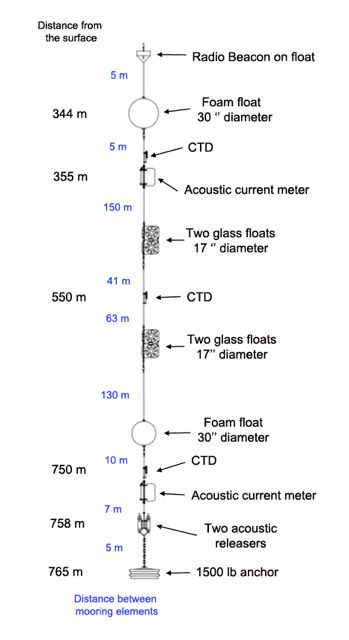
As you can see on the diagram, the mooring is anchored by a 1500 pound death weight. A 5 meter chain connects the anchor to the two acoustic releases. Their job is to open the link between the anchor an the rest of the mooring when we send a signal, so the buoys can float to the surface. The releases are also equipped with a transponder that communicates with the boat; we send a radio signal from the boat and the transponder will reply to it. We can tell how far we are from the mooring by timing the time it takes the radio signal to go back and forth.
The two current meters measure the speed and direction of the ocean currents (velocity) like the radar gun that police uses for measuring your car's speed on the highway. The CTDA research tool that is submerged in the water to measure conductivity (salinity), temperature, and depth. sensors are just like the ones we lower with the rosette. CTDA research tool that is submerged in the water to measure conductivity (salinity), temperature, and depth. means, as you might remember, Conductivity, Temperature Depth. We use the electrical conductivity of water to infer the salt content of the water, so with the CTDA research tool that is submerged in the water to measure conductivity (salinity), temperature, and depth. data we can know the salinity, temperature and pressure, and ultimately calculate density (see journal entry March 6).
There are two sets of glass floats. Each float has two half spheres of 1 inch thick glass on a plastic enclosure called 'yellow hats'. All floats need to be able to sustain the high pressure of being 800 m below the sea surface, so even the foam floats are made of an extra rigid plastic that prevents them from imploding.
You can see that the last float is about 340 meters below the surface. This is what we call a sub-surface mooring. How do we recover such mooring? As said before, the two acoustic releases receive the order from the ship to open the link between the cable and the anchor, and let go of the mooring above. That is when the hunt begins. All eyes will gaze the surface waters hoping to find the buoys.
The deck on the stern (aft deck) was cleaned and prepared for the recovery. Everybody is getting anxious for the new event of the cruise. This type of sporadic events help break the monotony of the every day CTDA research tool that is submerged in the water to measure conductivity (salinity), temperature, and depth. casting.
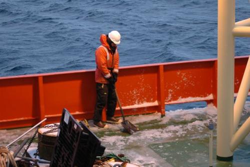
We arrived to the location a few hours ago and found it covered by pieces of ice known as pancake ice. It is an awesome view, but it is not helping us locate the mooring.
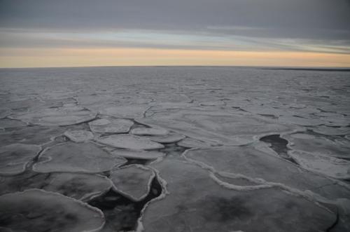
Usually we would trigger the releases when in the vicinity of the mooring because we could locate its beacon and radio transmitter from miles away. This time we have decided not to trigger the releases until we are certain that we are very close to where it will surface; we do not want to miss the beacon if the buoys remain under the ice. We faced another challenge with the first mooring. The transponder in the releases indicate the mooring was not in the exact location where it was left. We have been triangulating the ice patch to narrow down the location, and found that it has somehow drifted 1 mile from its original position.
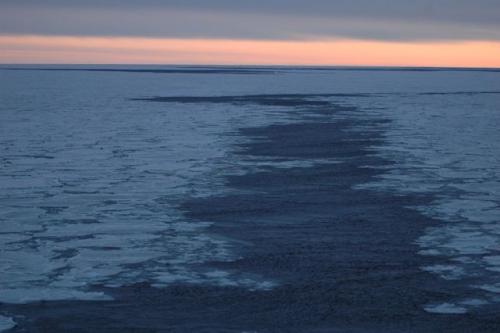
There is no more sunlight, and we will not recover the mooring in the dark. We are planning on finding the exact location of the mooring, and then do five quick CTDA research tool that is submerged in the water to measure conductivity (salinity), temperature, and depth. casts with the rosette on the shelf slope. We are only interested on the salinity and temperature data from the casts, so we only need to use four bottles from the rosette for calibrating the CTDA research tool that is submerged in the water to measure conductivity (salinity), temperature, and depth. data. We will go back to the mooring location tomorrow morning and retrieve it with full sunlight.
Here is a question for you. If we are only interested on four bottles out of 36, do we need to leave only four bottles open as the rosette is lowered to 800 m, or should we open them all? Send me your reasoning for doing it one way or the other.
Fondeos
El día para recoger el primer fondeo ( o anclaje) ha llegado. Antes de explicarles el proceso para recuperar el anclaje, que es bastante emocionante, te explicaré que es un fondeo y porque los utilizamos.
El objetivo de este crucero es el analizar las propiedades del agua de mar. Podemos ver que tanto cambian en el espacio al muestrear con la roseta en diferentes puntos a lo largo de la trayectoria del buque, como hemos venido haciendo hasta ahora. Es como tomar una fotografía de una rebanada vertical del océano y ver la distribución de sus propiedades. Al hacer esto suponemos que las propiedades no cambian significativamente en los dos meses que nos toma para completar el crucero.
Sabemos que las propiedades del agua marina cambian con el tiempo y que estos cambio ocurren a diferentes escalas de tiempo. Tú sabes de estos cambios ya que son similares a los que ocurren en la atmósfera. La temperatura y precipitación en tu ciudad puede cambiar de un día a otro, pero también cambia de acuerdo a las estaciones del año. Incluso cambian de año a año o década a década. Este invierno, por ejemplo, pudo haber sido más frío que uno hace 20 años.
Nuestro crucero oceanográfico está repitiendo las mediciones hechas hace 19 años para cuantificar los cambios que se han dado en un largo periodo de tiempo.
Alex también está interesado en estudiar los cambios que se dan en los océanos dentro de un año. Para poder resolver estos cambios tan rápidos sería necesario estacionar el barco en un sitio y muestrear con la roseta al menos cada día. Esto resulta poco práctico, ¿quién viviría una año en este barco estando en un sólo punto?, ¿de dónde sacaríamos la comida, combustible y demás artículos necesarios para vivir?
En cierto momento alguien pensó en dejar los instrumentos en el agua por todo un año y dijo, 'Hey, podríamos anclar un cable al fondo del mar con un objeto muy pesado y ponerle boyas al otro extremo para que lo mantengan en posición vertical.Entonces le amarramos todo tipo de instrumentos para que midan lo que queramos. Les ponemos un sistema de grabación para recuperar la información cuando recuperemos el fondeo un año después'. Y eso es lo que hicieron.
El Dr. Alejandro Orsi tiene objetivos muy particulares para los dos fondeos que instaló hace un año: 'el proyecto investigará los procesos que controlan el flujo de agua cálida del Agua Profunda Circumpolar (Circumpolar Deep Water) hacia la plataforma continental Antártica en el este del Mar de Ross'. Ya explicaré porque es interesante este problema más tarde (y léete el diario del 9 de marzo si no sabes que es el Circumpolar Deep Water).
Hay muchos tipos de fondeos con diferentes instrumentos. Los más grandes tienen una boya grande sobre la superficie del agua en la que se colocan instrumentos meteorológicos e instrumentos oceanográficos atados al cable. Algunas de estas boyas incluso pueden mandar los datos v´a satélite en tiempo real. Los fondeos que esperamos recuperar hoy son meas pequeños, pero muy efectivos. Aquí está un diagrama de los fondeos:

Como puedes ver en el diagrama, el sistemas se encuentra anclado con un peso muerto de cerca de 680 kg (1500 lb). A 5 metros hacia arriba se encuentran dos liberadores acústicos. Su trabajo consiste en abrirse cuando apretamos un botón en el barco para romper la conexión del cable con el peso muerto para que las boyas suban hasta la superficie. Los liberadores están equipados con un repetidor de ondas de radio para comunicarse con el barco. Nosotros mandamos una señal y el liberador contesta con otra señal. Podemos saber que tan lejos estamos del fondeo al medir el tiempo que tarda la señal en ir y venir.
El sistema tiene dos correntímetros acústicos (Acoustic current meter) que miden la dirección y rapidez de la corriente (velocidad) de forma similar a los radares que usa la policia para ver que tan rapido manejas. Los tres CTDs son similares el que tenemos en la roseta. CTD significa, como podrás recordar, Conductividad, Temperatura y Profundidad (en inglés). Utilizamos la conductividad eléctrica del agua para inferir la salinidad del agua, así que con el CTD podemos saber la salinidad y temperatura que nos permiten calcular la densidad (ve la entrada del 6 de marzo).
Los flotadores mantienen erguido al anclaje. Se tienen dos de un hule espuma especial para soportar las grandes presiones a esas profundidades, y dos sistemas de dos boyas de vidrio cada uno (Two glass floats). Cada boya de vidrio en realidad tiene dos medias esferas de 2.5 cm de grosor encapsuladas en una cobertura de plástico llamadas 'sombrero amarillo'.
El último flotador contiene un estrobo y un emisor de ondas de radio para poder ubicarlo. Se encuentra a 340 m metros debajo de la superficie, por lo que todo el sistema se conoce como fondeo sub-superficial. ¿Cómo se puede recuperar el fondeo si está tan profundo? Como dije antes, los liberadores acústicos cortarán el cable en su base para que todo el sistema flote a superficie ayudado por los flotadores. Aquí es cuando empieza la caza. Todos los ojos se posarán atentos sobre la superficie del agua para ubicar las boyas cuando salgan.
Se limpió la cubierta de popa en vísperas de la recuperación. Circula por el barco una gran emoción por empezar la faena. Este tipo de eventos esporádicos ayudan a romper la monotonía diaria.

Llegamos al sitio en el que se dejó el fondeo hace unas horas y nos encontramos con una superficie llena de pedazos de hielo que se les conoce como 'pancakes'. La vista es hermosa, pero no nos ayuda para ubicar el anclaje.

Normalmente apretaríamos el botón de los liberadores estando en la vecindad del fondeo, ya que se pueden ver las boyas a kilómetros de distancia. Esta vez hemos decidido posicionarnos justo en el punto en que saldrán las boyas por el temor de que el hilo las esconda. Encontramos otro reto al llegar al sitio en el que se dejó el anclaje; las señales de radio de los liberadores indican que ya no está donde debiera. Hemos estado trianagulando el área en busca del sitio actual. Encontramos que el fondeo se desplazó kilómetro y medio.


Se nos acabó la luz del día, y no recuperaremos el fondeo en la oscuridad. Esperamos encontrar el sitio exacto donde está el fondeo ahora y hacer cinco lances de CTD con la roseta en la pendiente de la plataforma continental. Sólo estamos interesados en medir la temperatura y salinidad, por lo que solo se usarán cuatro botellas de la roseta para calibrar el CTD.Nos iremos al sitio del fondeo para recuperarlo al alba.
Una pregunta para ti. Si sólo se van a usar cuatro botellas de las 36 en la roseta, ¿necesitamos abrirlas todas o tan sólo las cuatro que vamos a usar? Mándame tu respuesta con la razón por la que escogiste esa respuesta.


Comments