
Thomas-Jakobshavn 01
Our first flight of our final week here in Greenland gave us 100% data over another important baseline (priority) mission, covering the fastest-moving glacier in Greenland! Deputy Project Scientist Joe MacGregor referred to the Jakobshavn Isbrae, which flows 17 km/year at its fastest point, as "The Beast." The reason was evident when we flew over dense fields of crevasses, melt ponds, and ridges as we neared the retreating terminus. Scientifically this glacier is a "beast" because it's complexity makes it difficult to measure, yet its high rate of change demands the most accurate data we can provide.
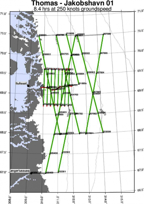
Take a look at our flight path below to get an idea of the scope of the region we are measuring today. Beginning in Kangerlussuaq, we move along a northeast track to fly parallel paths up and down the Jakobshavn front. Those lines provide high resolution coverage for a 10 km square area of this quickly changing glacier. That grid had been run by the Airborne Topographic Mapper team since the 1990s and became a priority in 1997 when the motion of the glacier began to accelerate at a high rate. Operation IceBridge continues that same grid annually, but has extended the mission to include ground tracks from IceSAT 1.
In 2015, the mission was renamed Thomas-Jakobshavn in honor of polar scientist Robert H. Thomas, a great contributor to the study of mass balance in the Greenland Ice Sheet and Antarctica. Thomas played a huge role in the presence of airborne remote sensing early on when he argued for the advantages of using airborne laser altimetry with differential GPSA Global Positioning System (GPS) is a satellite-based navigation system used to track the location or position of objects on the Earth’s surface. correction. To hear more about Thomas's life and work visit the following link http://www.igsoc.org/news/bobthomas/
According to ATM data plotted over the course of 3 years, the Jakobshavn glacier has seen it's annual net volume loss quadruple between 2009 and 2013. There are a lot of factors involved. As the glacier speeds up, the basal sliding cannot keep up with the surface and calving occurs at the terminus. Rather than the acceleration resulting in a glacial advance, we're seeing heavy retreat due to this calving. The bed of the Jakobshavn glacier slopes down into a basin, but the surface of the glacier is filled with crevasses and ridges. This combination makes it difficult to sound the bedrock using radar which is one of the reasons it is such a high priority mission.


Date
Expedition
Weather Summary
Warmer in Kangerlussuaq with outside temperatures dropping to around freezing during our flight.
Temperature
52°F
Comments