What an amazing adventure!
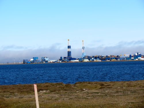
I was awestruck as we entered a futuristic world of heavy industrialism combined with dust, mud and the open tundra!

After several delays, and a flight change through Barrow, we had arrived in Prudhoe Bay! Dr. Okkonen immediately rented a pick-up truck ...and I'm going to guess that it's hard to rent any other type of vehicle, as everywhere we drove there were trucks, trucks and more trucks! We made several stops to pick up instruments and equipment and then we were off, traveling over dusty gravel roads that would wind their way to our final destination: The Research Vessel Ukpik! We meandered through a seemingly endless world of oil rigs, stainless steel pipelines and open tundra. It was like a scene from some futuristic movie. After passing through several security gates where our papers and licenses were thoroughly examined, we soon found ourselves at the dock with our traveling ocean research base, the R/V Ukpik. We unpacked the truck with the help of Captain Bill and Captain Mike and then threw off the lines that had tethered us to the dock. We headed out of the harbor and into the Beaufort SeaThe Beaufort Sea lies to the north of Alaska and the Yukon and Northwest Territories.. When evening approached we maneuvered into the lee of Thetis Island. As we moved into position we noticed a distant white ball of fur racing away from us down the beach. It was a polar bear! By the time we dropped anchor closer to shore the bear was long gone but I was still excited to see my first bear in the wilds of Alaska!
We awoke the following morning to the gentle slapping of waves against the Ukpik's hull. After eating a stack of cranberry pancakes we pulled anchor and said goodbye to Thetis Island, adjusting our course to a location that Dr. Okkonen and our research team has used the past several years as a site for oceanographic data collection. In the hours leading up to our arrival we organized, set-up and secured the instruments to the mooring frame. Getting the instruments ready for their three week stay on the ocean floor included hard work, brainstorming, power tools, the latest in computer technology and cooperation! The instruments will collect data over the next few weeks that will help scientists understand oceanographic conditions such as temperature, conductivity, salinity, zooplankton populations and current velocity. If you're interested in learning more about the instruments we're using in our expedition check back as I'll have a journal that focuses on the tools of an oceanographer in an upcoming journal!
Enjoy a tour of Prudhoe Bay and join us aboard the R/V Ukpik as we deploy oceanographic instruments on our way to Barrow!
http://
Through the Porthole
What are average ocean temperatures near Barrow in the summertime?

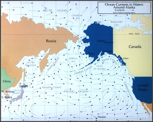
Due to the confluence of several ocean currents along this area of the coastline, ocean temperatures can vary quite a bit! To help understand why temperatures can vary you'll need to do a little work! First locate the town of Barrow Alaska on Diagram 1.

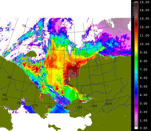
Now that you have an idea of where Barrow is located, find it again on the ocean temperature chart below.

As you can see, warm coastal water known as the Alaska Coastal Current enters through the Bering Strait and then flows northeastward where it intrudes into cooler Beaufort SeaThe Beaufort Sea lies to the north of Alaska and the Yukon and Northwest Territories. waters. This, combined with seasonal and annual variability as well as other factors can cause a wide range of sea temperatures in the Barrow area. In Diagram 2 you can see that areas around Barrow varied from 2 to 12 degrees Celsius (approximately 35-53 degrees Fahrenheit). Brrrrrrr! Pretty cold for Long Island but in Barrow the locals are enjoying a day at the beach!
Que aventura tan asombrosa!
Quede admirada a lo que entramos el mundo futurístico de industrialización pesada combinada con polvo, lodo, y la tundra abierta!

Bahia de Purdhoe
Después de varios retrasos, y un cambio de vuelo por Barrow, llegamos a la Bahía de Purdhoe! El Dr. Okkonen inmediatamente alquiló una camioneta… me imagino que ha de ser difícil rentar algún otro tipo de vehículo, ya que por todo lado que manejamos habían camiones, camiones, y más camiones! Hicimos varias paradas para recoger instrumentos y equipo y después seguimos, viajando por las carreteras empedradas y polvorientas que serpentean hacia nuestro destino final: la nave de investigación Ukpik! Nos movimos por un mundo sin fin de plataformas de petróleo, tuberías de acero inoxidable t tundra abierta. Era como la escena de un mundo futurístico. Después de pasar por varias entradas de seguridad donde examinaron completamente nuestros documentos y licencias, nos encontramos en el muelle de nuestra nave de investigación, la R/V Ukpik. Desempacamos la camioneta con ayuda del capitán Bill y del capitán Mike y echamos los cables que nos tenía amarrados al muelle. Salimos del puerto hacia el mar de Beaufort. Cuando caía la noche maniobramos hacia sotavento de la isla Thetis. A lo que nos movíamos en posición notamos a la distancia una bola de piel blanca corriendo de nosotros a lo largo de la playa. Era un oso polar! Cuando echamos ancla más cerca a la orilla el oso ya se había ido pero igual estaba muy excitada de haber visto mi primer oso polar en el silvestre de Alaska!
El mar de Beaufort
Nos despertamos la siguiente mañana con la suave bofetada de las olas contra el casco del Ukpik. Después de comer una pila de panqueques de arándanos alzamos ancla y nos despedimos de la isla Thetis, ajustando nuestro curso hacia una localidad que el Dr. Okkonen y nuestro grupo de investigadores han usado por los últimos años como sitio de colección de data. Horas antes de nuestro arribo organizamos, preparamos y aseguramos los instrumentos al marco de amarre. Alistar los instrumentos para su estadía de tres semanas en el fondo del océano incluyo trabajo duro, muchas ideas, herramientas eléctricas, lo último en tecnología de computación y cooperación! Los instrumentos coleccionarán data durante las próximas semanas que ayudara a entender las condiciones oceanográficas a los científicos, como son temperatura, conductividad, salinidad, populaciones de zooplancton y velocidad de corrientes. Si tienen más interés en aprender más acerca de los instrumentos que estamos usando en nuestra expedición chequea más tarde que tendré un diario con enfoque a herramientas de un oceanógrafo.
Disfruten un tour de la Bahia de Purdhoe y unanse con nosotros a bordo del R/V Ukpik mientras hechamos los instrumentos oceanograficos rumbo a Barrow!
http://
Atraves de la Ventanilla
Cuáles son las temperaturas promedio del océano cerca de Barrow durante el verano?

Debido a la confluencia de varias corrientes oceánicas a lo largo del la costa las temperaturas del océano pueden variar bastante! Para entender porque las temperaturas pueden variar necesitaran hacer un poco de trabajo. Primero localicen el pueblo de Barrow Alaska en el diagrama 1.

Ahora que tienen una idea de donde se encuentra Barrow, encuéntrenlo otra vez en la tabla de temperaturas oceánicas de abajo.

Como pueden ver, agua costera caliente conocida como la Corriente Costera de Alaska entra a través del estrecho de Bering y fluye hacia el noroeste donde se choca con aguas mas frías del mar de Beauford. Esto, en combinación con variabilidad temporal y anual, al igual que otros factores, puede causar gran variedad de temperaturas de mar en el área de Barrow. En diagrama 2 pueden ver que áreas alrededor de Barrow variaron entre 2 y 12 grados Celsius (aproximadamente 35 – 53 grado Fahrenheit). Brrrrrrr! Bastante frio para Long Island pero en Barrow, los locales están disfrutando de un día de playa!


Comments