Back In The Groove in Barrow!

    We’re back in the groove here in Barrow, with the normal cycling pattern of work days on the boat punctuated by (multiple) weather days when it is too rough to work at sea. On weather days, we sit in the office/lab, sometimes recovering from the work days, sometimes just wishing that the wind would stop blowing, and always glued to our computers. The weather turned colder for a while, which eliminated the mosquitoes. One day we saw snow flakes, another day a torrential downpour (strange, it doesn’t usually pour in Barrow, the precipitation tends to come down more gently).

    Rainbow over Niksiuraq.August 2014. Photo courtesy of Dr. Carin Ashjian.
    Rainbow over Niksiuraq. Niksiuraq (little fish hook) is the location where we get onto the Annika Marie, usually using a zodiac. When we first started working here, Niksiuraq provided a fairly deep haven for boats as well as a great location for another boat launching ramp. Now, winds and storms across an increasingly ice free Elson Lagoon have changed the topography of Niksiuraq, eroding the spit and filling in much of the sheltered area with sand. August 2014. Photo courtesy of Dr. Carin Ashjian.

    Breaking wave clouds.
    Breaking wave clouds over the Chukchi Sea. August 2014. Photo courtesy of Dr. Carin Ashjian.

    Sunset reflected.  The view from my room at about 1130 PM. The sun was setting and reflecting on the clouds that were to the east (seen here).  2014. Photo courtesy of Dr. Carin Ashjian.
    Sunset reflected. The view from my room at about 1130 PM. The sun was setting and reflecting on the clouds that were to the east (seen here). 2014. Photo courtesy of Dr. Carin Ashjian. August 2014. Photo courtesy of Dr. Carin Ashjian.

    On Tuesday we went across Barrow Canyon again, leaving in the morning and getting back to our lab at about 1 AM. Again, another interesting day with cold water in locations where we have been seeing warm for several years. This year, along with 2006 and 2008, is definitely a “cold year” in our record. The day started gray but by afternoon the sun was sparkling on the surface of the ocean.

    Knot tying session.
    Always time to lean some good knots! A bowline is probably one of the most utilized knots on boats. Steve teaches Kelsey (visiting from the Museum of the North in Fairbanks) how to tie a bowline. August 2014. Photo courtesy of Dr. Carin Ashjian.

    On our way out, we saw a huge white polar bear ambling along the crest of the narrow island that borders Elson Lagoon. Several seals popped up along our track, including a large, very curious oogruk (bearded seal) that kept stopping by to check us out, peering at us and extending quite high out of the water (spy hopping) until it turned and arced under the surface of the water with a jaunty flip of its tail flippers. We sampled through the daylight into the dusky hours of evening, occupying our last station near the islands at about sunset (unfortunately by then the sun had disappeared behind the clouds). Much to our surprise, although in retrospect we should not have been, we found huge quantities of krill, likely near the bottom, in our net tows!

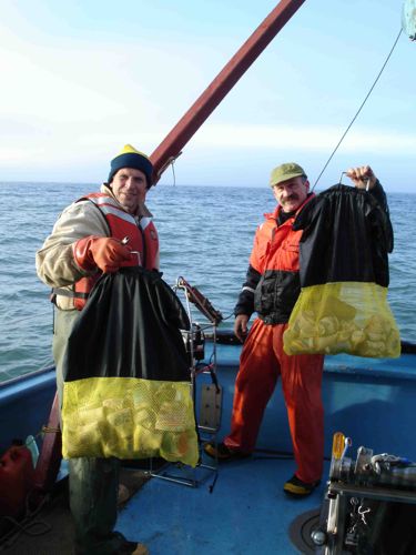
    The research team examines a sample.
    The research team examines a sample from the sea. August 2014. Photo courtesy of Dr. Carin Ashjian.

    We later realized that we would see krill piled up against the islands since the wind had been blowing from the east during the previous days (winds from the east causes deeper water off of the shelf to upwell into shallower depths and onto the shelf; we believe the krill are carried in that deeper water to the Beaufort SeaThe Beaufort Sea lies to the north of Alaska and the Yukon and Northwest Territories. from the Bering).
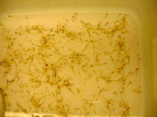
    Dish pan of krill back in the lab.  August 2014.  Photo courtesy of Dr. Carin Ashjian.
    Dish pan of krill back in the lab. August 2014. Photo courtesy of Dr. Carin Ashjian.

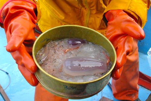
    Interesting sample from the bottom of the sea.
    Interesting sample. The contents of one of the nets from the Tucker trawl. Note the huge ctenophore in the lower right quadrant of the sieve. Note also the arctic cod in the upper left. August 2014. Photo courtesy of Dr. Carin Ashjian.

    Under Pressure!

    At the deepest station that we sampled, we sent some Styrofoam cups down with the CTDA research tool that is submerged in the water to measure conductivity (salinity), temperature, and depth.. Deployment of Styrofoam cups (and other shapes) are a classic oceanographic demonstration of the effects of pressure in the ocean.

    Steve and Phil loading the styrofoam cups
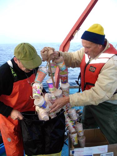
    Dr. Okkonen (right) and Phil Alatalo enjoying a moment with the tangled "legs" of Styrofoam cups decorated by Springs School students as part of an ocean depth vs. pressure activity. August 26, 2014. Photo courtesy Dr. Carin Ashjian.

    Two years ago, Lisa Seff participated in our fieldwork through the ARCUS PolarTrec program. This summer, she sent us up some cups for us to deploy decorated by students at the Springs School in East Hampton NY, as well as PolarTREC educator Susan Steiner's students from North Carolina.
    Loading the cups
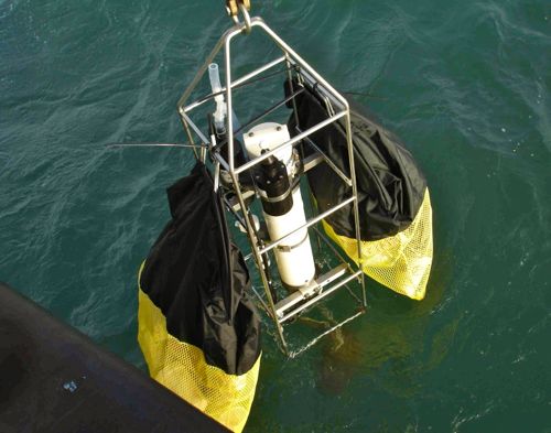
    Phil and Steve putting the cups into the two dive bags that Lisa sent up. The cups are in nylon stockings that have been knotted between each cup to prevent the cups from nesting (sort of like pearls on a string). August 26, 2014. Photo courtesy Dr. Carin Ashjian.

    Loading the last of the cups into the dive bag!
    Dr. Okkonen (right) and Phil Alatalo loading the cups into the dive bags. August 26, 2014. Photo courtesy Dr. Carin Ashjian.

    Attaching the cups to the CTD.
    Dr. Okkonen and Phil Alatalo attach the cups to the CTD. August 26, 2014. Photo courtesy Dr. Carin Ashjian.

    CTD and cups being lowered into the depths of the Barrow Canyon.
    The CTD and cups being lowered into the depths of the Barrow Canyon. Latitude:71 degrees 33.597 minutes North. Longitude:155 degrees 54.244 minutes West. Time:1924 ADT. August 26, 2014. Photo courtesy Dr. Carin Ashjian.

    Cups going down!
    The styrofoam cups heading down. The CTD as it was deployed with the cups. The cups of course floated upwards and were the last part of the package to submerge. August 26, 2104. Photo courtesy of Dr. Carin Ashjian

    Cups finished!
    The cups return to the surface! How did the pressure effect them? August 26, 2014. Photo courtesy of Dr. Carin Ashjian.

    To find out how deep the cups went with the CTDA research tool that is submerged in the water to measure conductivity (salinity), temperature, and depth., and exactly what happened to them, check back with us in a future journal (which will be titled: Styrofoam Cup vs. Deep Sea Pressure Challenge:Part 3!)

    Tutu Stew and Wow! Gas Prices!

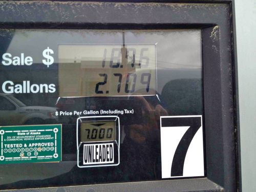
    The other day, we were invited by Billy Adams, who works down the hall, to enjoy some homemade tutu (caribou) stew. Caribou are found out on the tundra south of town and provide important food for the years. The caribou stew was delicious and an excellent mid-morning snack. When I went to the gas station yesterday, I saw Sean (who works for the logistics provider that we use here) and his cousin who were heading out on their four wheelers for an evening of hunting. If you think gas is expensive where you are living, well, try coming to Barrow.
    Getting gas for the truck.
    Getting gas on land. Note the price per gallon of gas above the “unleaded” label. August 2014. Photo courtesy of Dr. Carin Ashjian.
    Luckily the truck that we are using this year is fairly new and seems to have better gas mileage than trucks we have used in the past.

    Getting gas for the boat.
    Getting gas at sea. Bill (boat captain) hands the signed credit card receipt to the driver of the fuel truck (left) after gassing up the R/V Annika Marie. It was calm enough that the fuel truck could back down the town boat ramp and that Annika could nose up to the beach, thus permitting the fuel hose to reach the fuel input on the boat. August 2014. Photo courtesy of Dr. Carin Ashjian.

    We had high hopes last night of getting out on the water today but woke to a steady rain and gusty wind and small craft advisories. So we are tucked into the lab, watching the changing weather (it is getting brighter and not raining now). The weather forecast tells us that tomorrow is going to be better.

    Comments

    Jillian

    Hi Lisa, Great journal, and the diversity on what you are posting is marvelous. Can you let us know how far down the cups went? A is so much.
    Jillian

    Mason Webb

    Well as fun as it might be to try to crush something or just see what it does underwater with intesensive pressure, but what advances can this undercover?

    Lisa Seff

    That’s a great question Mason and this activity does uncover and relate to many oceans related topics, for students across all grades! Sending styrofoam cups to the bottom of oceans around the world has been one way that ocean explorers, and now our own student explorers from our school, are involved in a simple and fun activity to connect to, and study, the complexity of our oceans, the organisms that inhabit them as well as the difficulties scientists face when conducting research at great depths.
    Our students, depending on the classroom age and curriculum will be using the Styrofoam cups to focus on the following questions:
    1) How do air pressure and ocean pressure compare?
    2) How do ocean pressure and air pressure change with depth and altitude?
    3) Is ocean pressure uniform?
    4) Does the ocean pressure effect the density of the Styrofoam? How?
    4) How do changes in ocean pressure effect organisms that live at great depths?
    5) How do changes in pressure effect SCUBA divers?
    6) With a NOAA bathymetric chart of the Barrow area, can students correctly plot the latitude and longitude to estimate immersion depth?
    7) If we know the depth, can we calculate the amount of pressure that the cups will be under?
    8) If we know the amount of pressure the cups were under, can we estimate the percent they will change?

    If you’re interested in following our students as they explore these questions, stay tuned to upcoming “Challenge” journals! The cups will be heading back to our students in New York in the next few weeks!

    Lisa Seff

    Hi Jillian! We're so glad you are enjoying the journals! I can't let you know how far the cups went yet, as we'd like students to try and figure that out on their own, with a little help from observations of the cups themselves (comparing before and after cups, which we can't do until the cups get back to NY, probably in a few weeks), as well as NOAA charts and some mathematical formulas. However we will post information that you can use to figure it out too! Just keep an eye out for upcoming "Deep Sea Pressure Challenge" journals. If you're a teacher, and want to know sooner than later, you can send an e-mail from your school e-mail to my e-mail at: lseff@springsschool.org