Winds, Waves, and Winter
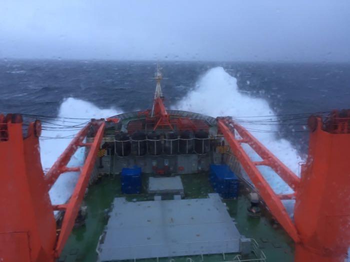
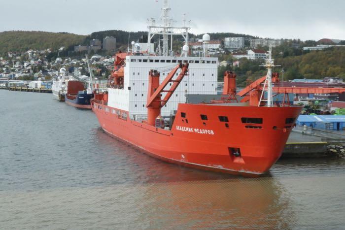
I wrote the first version of this Journal Entry on September 24, 2019 as we were transiting across the Barents and Kara Seas to the sea ice edge. Our latitude at the time was 78 degrees, 50.3102 minutes North and longitude was 058 degrees 21.3999 minutes East. It was starting to feel quite a bit like winter there at 78 degrees north. We had had a lot of snow blowing around in the prior two days. That morning, the clouds sat like a thick grey blanket above us. Winds were blowing 30-35 knots and some of the swells were estimated at as much as 4-6 meters (12-18 feet). We actually shifted our course slightly to avoid even stronger winds and waves. The Fedorov is a big, stable ship. We were actually fairly comfortable despite some pitching and rolling.
More recently, the Polarstern experienced a major Arctic storm, with winds up to 40 knots. This offered the researchers a great opportunity to study how high winds impact ice movement and the effects of Arctic cyclones like this on climate processes. At the same time, the storm caused major logistic challenges. During the first major storm, on the weekend of November 15, the main ice camp broke into pieces and parts of the floe moved about 600 meters (1/2 mile) southeast and across the bow of the ship.
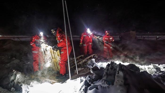
None of the research equipment was lost to the ocean, but everyone has been working hard to get things set back up in places on the floe where they are safely accessible and to get the electrical system reconnected. This is but one of the challenges facing the MOSAiC team, but this is the reality of Arctic research. Information on the storm is available through this update on the MOSAiC Expedition web app and through a blog post by CIRES videographer Amy Richman.

Whatever the season, wind is an important and fascinating part of global weather. Check out this very cool website for a real-time visual of wind speed and direction around the globe! Look at the winds near where you live, as well as the winds where the Polarstern is now: 86 degrees, 7 minutes North and 119 degrees, 9 minutes East. What wind speeds does the map indicate they are experiencing at the surface? How does this compare with the winds speeds in your home?
You can also change the characteristics that appear on the map. Click on the icon in the lower left hand part of the map to choose different altitudes for the wind or even different characteristics like wave height, water currents, air temperature, and so on. If you can, take a look at the air pressure in the region. An overlay of mean sea level pressure will appear if you click on 'MSLP.' Do you notice how winds seem to spiral around areas of high pressure -- indicated by white or silver on the map -- and low pressure -- indicated by purple or red on the map?
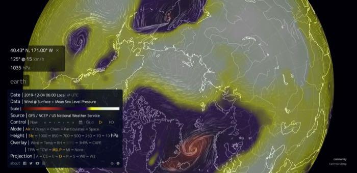
When we encountered the storm in late September there was a low pressure system to the southeast. To the northwest of us, a high pressure system. Air generally flows from the high pressure system to the low pressure system, and this causes wind. The greater the difference between the high and low pressure, the faster the winds usually are. Distance between the pressure system also matters -- steep pressure gradients (big differences over shorter distances) create higher winds. So this, more or less, determines the intensity of the wind.
However, the direction of the wind that we experience on the land and the ocean surface isn't really a straight flow from high to low pressure areas. Because the earth is rotating at quite high speeds, something called coriolis effect or coriolis acceleration impacts the direction of the wind. In the northern hemisphere, this deflects wind direction towards the right (clockwise). And in the southern hemisphere, coriolis acceleration deflects wind direction towards the left (anticlockwise). Coriolis can be difficult to understand, but there are some great demonstrations and videos online. This video from CIRES includes information both about pressure and coriolis acceleration.
Just be careful if you look for other videos! There are lots of myths about the coriolis effect. For example, don't believe anything about the direction of a toilet flush being affected by coriolis; the distances involved must be much greater than a toilet bowl for coriolis to have an influence. So unless the toilet is miles across, coriolis acceleration is unlikely to have any impact. I've heard this myth for a long time, but only recently learned for sure that it isn't true.
Of course there are lots of other factors that influence wind speed and direction, but for now let's stick with the simple story of wind science. Beyond understanding how wind is created, the reality of wind on the ship affects life on a daily basis. The storm created fairly big swell. Swell describes large waves that build up over long distances in the ocean, which move faster or in different directions than the wind. Wind waves are more local winds that are driven directly by wind energy. Both swells and wind waves can make it a little challenging to walk down the narrow hallways. Some people felt seasick, but I was lucky and never really had much of an issue with seasickness. All of our items needed to be carefully secured in our cabins on the ship. The scientists worked hard y to make sure all of the equipment was tied in place so nothing shifts or gets tossed around by the waves. When I stepped outside, the cold wind steals warmth from my face and hands. But the fresh blowing air also instantly woke me up if I was sleepy. Since we kept crossing time zones and losing an hour each night, it was helpful to have this trick to keep me alert. I do love the feel of strong winds near (or on) the ocean. This is something I've enjoyed since I was a kid. I still love being on the beach in a fall storm. The power of the wind and waves awes me!
And I love enjoying a cup of tea or hot chocolate after coming in from the storm. I never found hot chocolate on the Fedorov, but the galley provided lots of tea and I bought 5 boxes of my own favorite teas. We even had a special meal at 3:30 pm every day called tea time!
Word of the Day Since the Fedorov is a Russian vessel, the crew primarily speak Russian. We were lucky to have two scientists on board who were also helping to serve as translators. As part of our general meeting each day, they taught us important words to know. In this section, I share some of the words we learned. For today: spasiba which means the same thing as thank you. Also pozhaluysta which can mean please, you're welcome, here it is, or apparently a long list of other things too!
Your Questions and Curiosities A reader who knows about the coriolis effect asked what happens at the North Pole. Is coriolis acceleration stronger or weaker? On a tiny scale, there is no coriolis acceleration exactly at the North Pole (or South Pole for that matter). However coriolis acceleration only occurs over fairly large distances -- usually more than a mile. In the areas immediately around the Pole, coriolis acceleration is actually the strongest. So air flowing along a pressure gradient away from or towards the North Pole would experience strong coriolis acceleration. The researchers I spoke with were unsure over what distances, object masses, and speeds you might be able to see coriolis acceleration in effect if an object was in flight from the North Pole. There was broad conjecture that you might be able to notice it if some with a skill for it tried to hit a baseball due south while standing at the North Pole. Perhaps one day someone will be able to test this out.
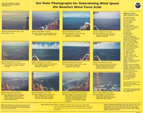
Education Extension The Beaufort Scale is a fantastic way to measure winds. This scale allows you to make visual observations and record a general wind speed. These observations usually include looking at things in the environment like waves, smoke, trees, or flags, and noticing how they are behaving in the wind. Choose a version of the scale that makes sense for where the students will be making observations. Here on the boat, looking at the surface of the water and behavior of waves and sea spray makes sense! Looking at whether or not leaves are rustling or trees are swaying does not make sense, since I can't see any trees! So make sure you choose a version of the Beaufort scale that includes the right sort of indicator for your location. Print out copies of the Beaufort Scale and have students make daily observations of wind speed and direction for a week or more. Discuss what they observe and compare it to the winds experienced in other parts of the world.
Understanding that winds are created by differences in high and low air pressure is really useful. Once students understand this and the impact of coriolis acceleration, they can use weather maps showing barometric pressure to predict relative wind speed (low, medium high) and direction. The Center for Alaskan Coastal Studies has some lessons related to this on the AdaptAlaska Website. Check out Pressure & Storms Lesson - CACS CoastWatch Curriculum for lab activities surrounding barometric pressure and weather prediction. Coriolis & Currents - CACS CoastWatch Curriculum is focused on coriolis acceleration and water currents but has some good resources to support learning about coriolis acceleration.
For a boost of math and science processes, make predictions before they collect any using the Beaufort Scale. Ask students to share any experience or knowledge they have about predominant wind speeds and directions for this time of year in your location. Is it usually very windy? Is there one direction the winds often come from? Combine this information with regional maps of barometric pressure and the students can try to predict the wind directions. You can even print out the wind predictions from the National Weather Service, but don't show these to the students yet. After collecting your data for a week or more, see if it fits the student predictions. Does it fit the National Weather Service predictions? What else might affect wind speed and direction in your region and be the cause for any inaccuracies?
And on-the-ground measurements of wind can be really useful to scientists, especially if you live in a more remote part of the world where there aren't nearby weather stations to ground truth predictions and remote sensing. The GLOBE Program, through NASA, is a fantastic citizen science opportunity. Once you are trained, your students can follow specific protocols to collect and submit data about wind speed and many other atmospheric, soil, and water characteristics. On a more local scale, contact the closest weather office to see if there are ways your information could be useful to them. But wind affects us all! There may be others in your community, such as the village agents for flight services or hunters associations, that would be interested in longer-term wind monitoring programs.

Comments