
As promised, I've been adding photos I took during the expedition to previous Journals. Check out 'Hey Bear!' for some new photos of polar bear guards and beautiful arctic landscapes.
Earlier, Catherine asked about coring rock, sediment, or ice sheets. As a reader of PolarTREC journals, Catherine is hoping to learn more about the geological history of the area. There isn't any sediment or ice sheet coring happening through MOSAiC; however, there were people onboard the Fedorov who research permafrost and use permafrost cores to understand geologic history as well as current changes.
I learned from one of these scientists about sub-sea permafrost. What an interesting phenomenon! PermafrostPermanently frozen ground. refers to any ground or rock that remains at or below 0 degrees Celsius (32 degrees Fahrenheit) for two or more consecutive years. Basically, it is permanently frozen ground (though we are about to learn an exception to this). Oftentimes, there is an active layer of ground above the permafrost that is frozen part of the year and thawed part of the year.

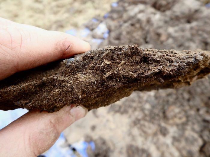
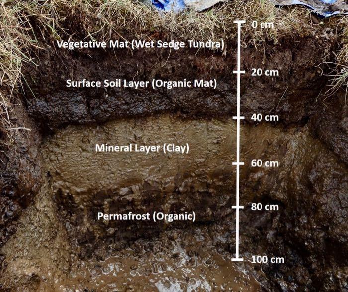
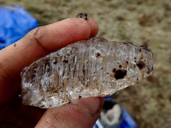
Knowing the definition of permafrost and active layer, how do you think sub-sea permafrost came to be? What processes do you think created these pockets and expanses of frozen ground below the ocean? If you are willing, put your theories in the comments below before you read on. When I first heard about sub-sea permafrost, I had no idea how it could be formed. I'm interested to hear your initial guesses! While you think about it, here are some photos of permafrost, tundra soil and permafrost layers, and a chunk of ice from deep within the permafrost. All three photos are by David Walker (PolarTREC 2019) courtesy of ARCUS and were taken at Imnavait Creek, North Slope, Alaska.
Okay, so scientists know of two ways that sub-sea permafrost can form. In both instances, the permafrost first forms in the ground on land. So let's talk first about how that happens. Average yearly temperatures of below 0 degrees Celsius (32 degrees Fahrenheit) lead to frozen ground. This frozen ground often includes ice but doesn't necessarily have to. The ice content can be anything between 0% and 100% and still be considered permafrost. Most permafrost is quite thick; it can be over 1000 meters (2/3 of a mile) thick. Often, permafrost has been frozen for hundreds if not thousands of years.
For this terrestrial permafrost to become sub-sea permafrost, it must be inundated (flooded or covered) in coastal regions. One way that this happened is due to long term climactic shifts. As massive ice sheets and glaciers have melted over the past few thousands of years, the sea levels have risen significantly. In some low-lying coastal areas along the shelf regions of the Arctic, saltwater covered areas of land containing permafrost. The permafrost was inundated and became sub-sea permafrost.
An important note: The long-term climate shifts that led to this deglaciation (loss of glaciers) are different than the rapid, largely human-driven climate change we are experiencing now.
")
TerrestrialPertaining to land. (land-based) permafrost can become sub-sea permafrost on shorter time scales as well. Usually this is caused by coastal erosion. Waves and winds can cause coastal bluffs to wear away and erode into the ocean. Sometimes even freeze-thaw cycles can make unstable bluffs fall into the ocean. Major rain events or snow melt can also contribute to the erosion. When coastal erosion occurs, the active layer slumps into the ocean. Now the land and permafrost it contains are below the water line, and saltwater inundates them.
Notably, decreasing sea ice extent is making many Arctic coastal areas more vulnerable to storms that drive erosion. In the past, shore fast ice would have dampened the waves of fall and winter storms. But if that ice hasn't formed yet, the waves can hit the coastline harder, eroding large chunks of bluff and beach. I wonder if this affects the rate of sub-sea permafrost formation.
, Courtesy of ARCUS.")
There is a team of researchers at the Alfred Wegner Institute, including Michael Angelopoulos who first told me about sub-sea permafrost, working on understanding the extent and dynamics of sub-sea permafrost. You can learn more about their research team here and read a recent paper detailing the formation, ongoing research, and importance of sub-sea permafrost.
One of the astounding things about sub-sea permafrost is that it can exist in an un-frozen state. What? Isn't permafrost frozen ground? How can it be permafrost and not be frozen? Well, remember the earlier definition of permafrost. It must be below 0 degrees Celsius (32 degrees Fahrenheit). In most situations, this means it is below the temperature at which water freezes from a liquid into a solid. However, saltwater freezes at lower temperatures. Much of the water along the coastal shelves of the Arctic is salty enough that it can reach -1 or -2 degrees Celsius before it freezes. Super salty water freezes at even lower temperatures.
When sub-sea permafrost is covered by this cold ocean water, it usually stays at temperatures below 0 degrees Celsius because the ocean water is at temperatures below 0 degrees Celsius. This means that it still fits the definition of permafrost. But, saltwater quickly begins to move into the upper layers of permafrost. The addition of salt changes the temperature at which the sediments will actually freeze. Once enough salt gets into the permafrost, it thaws. It isn't unusual for the top layers of sub-sea permafrost to be unfrozen permafrost! Over time, the salt penetrates deeper and deeper into the sub-sea permafrost, and over hundreds or thousands of years the thaw will spread. In 2017, scientists [alerted the world] (https://www.su.se/english/research/research-news/arctic-subsea-permafrost-is-thawing-faster-than-thought-1.338333) that sub-sea permafrost in the Eastern Siberian Arctic Shelf was thawing more rapidly than had been previously expected.
Not only is sub-sea permafrost fascinating, it is important to understand for a number of reasons. Mapping where sub-sea permafrost exists and certain features are can help researchers piece together stories of the land, sea level rise, and climate shifts over time. It is also important in understanding how changes to permafrost - both on land and under the ocean - can impact communities and how communities are reacting to this. The NUNATARYUK project seems to be doing a great job of bringing together Indigenous Knowledge and Western Science to better understand and respond to changing permafrost. The NUNATARYUK Science Page has some really useful maps and diagrams, as well as links to data visualization tools.
Some areas with oil and natural gas development or other nearshore infrastructure may be in places with sub-sea permafrost. As sub-sea permafrost thaws, the sediment often collapses downward. Protecting this infrastructure involves understanding where sub-sea permafrost exists and the dynamics of thaw.
Sub-sea permafrost also contains methane that was trapped over long periods of time. When permafrost thaws, this methane is released into the sediments and water. From there, it may stay in the sediments, circulate in the ocean, be frozen into sea ice, or be used by organisms. However, this methane can also end up in the air. Methane is a powerful greenhouse gas. If large quantities of methane are released by sub-sea permafrost, this could drive additional climate change. However, it is still unknown whether or not the amounts released by sub-sea permafrost are significant. More research is definitely needed.

There are probably many more reasons that sub-sea permafrost is important, but a particularly fun one has to do with understanding outer space. It turns out that many features of sub-sea permafrost (and permafrost generally) have similarities to features on planets and moons in our solar system. Since it is really hard to do field work on Mars, for example, scientists can study parts of permafrost formations that are analogues (features that are similar) to what they see in images and data from Mars. This can help them to come up with possible explanations for the features on some of the moons and planets in our solar system and drive further research questions. Also -- some researchers even use these permafrost landscapes as testing grounds for the equipment they will deploy in space! Some of these permafrost features are so strange and extreme it truly is 'like being on another planet.'
Your Questions and Curiosities A reader 'AskMOSAiC'ed about linkages between faster rates of warming in the Arctic and methane release in the tundra. In particular, they were curious if the methane released from Arctic permafrost was kept in the northern region by atmospheric patterns, thus contributing to more rapid warming in the Arctic. As far as I know, this climate feedback loop is not that localized. Methane released from permafrost is a powerful greenhouse gas. As warming temperatures cause permafrost to thaw, it is likely more methane will be released. More methane release will contribute to increased climate change. This will likely push a trend of further overall warming in the Arctic, which in turn leads to the release of more methane. So it could be a significant feedback loop. However, this methane disperses in the atmosphere and doesn't just remain concentrated in the Arctic. Therefore, the impacts are global and not focused on the Arctic.
The general explanation for faster rates of warming in the northern polar region is called Arctic Amplification. Arctic Amplification is a more localized feedback loop. As snow and ice cover melt, ocean and tundra are revealed for more of the year. Darker surfaces, like water, plants, and soil absorb a whole lot more radiation from the sun than snow and ice do. The proportion of light that is absorbed or reflected/refracted by a surface is called albedo. ClimateThe average weather over a particular region of the Earth. Climate originates in recurring weather phenomenon that result from specific types of atmospheric circulation. change is generally driving decreases in the duration and extent of sea ice cover in the Arctic Ocean and snow pack on much of Arctic lands. Therefore, the land and water that are exposed by this melting absorb more heat. Because of this local effect, temperatures are rising faster here than the global average. And of course, as temperatures rise, sea ice and snow continue to be lost, creating a vicious feedback loop.
Education Extension I suggested activities related to ice and soil coring in a prior Journal about ice coring. If you didn't have a look at them there, I encourage you to do so now.
I didn't look for any educational resources specifically about sub-sea permafrost before I came on this trip because I didn't even know sub-sea permafrost existed! However, in my search since returning, I haven't found many educational materials for K12 about sub-sea permafrost. Since it isn't a MOSAiC topic, I need to finish other activities first. But in the near future, I would like to add some activities and experiments for investigating sub-sea permafrost.
For more information and educational resources about coastal erosion as well as other hazards driven by climate change in Alaska, check out AdaptAlaska.org. This storymap and mapping tool are fantastic resources for learning more about coastal erosion in Utqiagvik and the North Slope of Alaska. This unit from Alaska Seas and Watersheds provides a series of labs and activities for high school students to learn more about erosion processes and then engage in community monitoring and erosion mitigation plans.
Comments