


We have just finished working at the Ushishir Group, which includes two small islands, Yankicha to the south and Ryponkicha to the north. They are what remain of the catastrophic explosion of the Ushishir volcano that occurred about 9500 years ago. Yankicha is the caldera remnant and Ryponkicha is a narrow island only separated from Yankicha by a shallow channel. Last year we spent half a day on each island, digging test pits on the north end of each.
In the test pit that I helped dig on Ryponkicha we found some bone midden (see my August 10-11, 2006 TREC Journal for more details), so Mike Etnier and I were going to return to the same location and dig a larger 1 m by 1 m excavation unit to recover a bigger, more organized sample of material, collect charcoal samples from the cultural levels for radiocarbon dating and to "find the bottom”. Finding the bottom means that we would excavate until we find culturally sterile soils – that way when we date charcoal that is collected from that level, we can feel confident that we know the earliest time that people lived in that location.
We landed on a moderately foggy morning on the Pacific side of the south end of Ryponkicha. Ryponkicha is a steep sided island with narrow beaches about a half kilometer at its widest and about 3 kilometers long. On top of the terrace, the island is generally flat and sloping downward to the north. It is covered with tall grasses along the edges and southern end and very short tundra vegetation in the middle. The grasses are very squishy and full of tussocks, so you have to lift your knees a lot as you walk through them, which is tiring. The tundra is easier to walk through, but underlying the crusty lichens and mossy-like tundra plants is a layer of thick, gooey mud that gave us the impression of stepping in "dog doo” each time the crust slipped on top of it. Eeuuww!
Mike and I climbed to the top of the nearly 100 meter terrace above where we landed in about 20 minutes or so and began our trek north to the site. Due to the fog, our route was a bit rambling and it took about an hour to traverse the island and locate the old test pit. We paused for a snack and then laid out our plan for the excavation unit.
*Alexander Rybin standing at the foot of the nearly 100 meter terrace on Ryponkicha. The archaeological sites are on top of the terrace, so we had to climb up this slope to get to them! *
We decided to align the unit generally along the south edge of the old test pit, set the stakes around the perimeter (using that same technique of knowing the hypotenuse of a 1 by 1 square…), tied string and removed the sod. We worked throughout the day to excavate about 30-40 centimeters of dirt, finding mostly flakes, a few pieces of ceramics, decent amounts of charcoal and quite a lot of poorly preserved bird bones.
Mike Etnier measures the depth at the corners when we have finished excavating Level 2 of Unit 1 at the Ryponkicha 1 excavation site. After each level is completed, we measure how deep the corners and middle are below the surface and record this on the unit-level form.
By late afternoon, when we covered the excavation with the sod pieces to protect it overnight and started to head back to the south end to rendezvous with the tsunamist group and go back to the ship, the fog had cleared and it was sunny. From our vantage point we could see the islands of Rasshua, Matua and little Raykoke in the distance to the north and to the south we could see all of Yankicha and Ketoy. Five other islands!
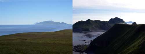
*On Left: The view north from the top of Ryponkicha on a clear day. Rasshua is the nearest, most prominent island, with Matua’s Sarychev peak peeking up just behind it. Furthest in the distance is small Raykoke Island. Between Ryponkicha and Rasshua, you can see the low-lying reefs where there are northern fur seal breeding colonies. *
On Right: The view south from the top of Ryponkicha. Yankicha, its sister island, is nearest, just across the shallow, narrow channel and is the caldera remnant of Ushishir volcano’s giant eruption about 9500 years ago. In the distance is Ketoy with its steaming, active lava dome caldera.
After our descent to the beach, we discovered that a few of the more nefarious members of the many foxes that inhabit Ryponkicha had not taken too kindly to our leaving our hip boots and life jackets on the beach for the day. Both of our boots had holes chewed in them – mine at the top edge of both boots, Mike’s at the knee – and then liberally peed upon! Fox urine is extremely stinky! We shook our fists at the mocking foxes, gingerly put on the boots and tried to rinse them in seawater before we headed back to Iskatel for the evening.
The next day we would head back to the north end of Ryponkicha to finish the work that we had begun.
Da svidanya do zaftra! (Good bye until tomorrow) Misty
Comments