
Today, the most frequently-heard words out of Bre’s mouth were: "Holy Crap!”
We began the day with our typical breakfast of leftovers and/or muesli with milk. Then we got our gear together and hiked over to Ainu Bay, which is on the south-west side of Matua, on the Sea of Okhotsk side. Last year, at about this time, most of the geology group, including Tanya, Katya and Bre, camped here for 3-4 foggy days, measuring profiles and making excavations. We greatly hoped as we hiked that the fog would lift enough to be able to take a photograph of the beach to compare it to ones that we took last year. We thought this would be Jody and my last day on Matua and our last opportunity to see Ainu Bay. The single biggest mistake that we made was deciding NOT to take a tripod and the nivelier with us, but only the hand level and stadia rod.
It was a decent hike to Ainu Bay, up and over the island. We walked along some old military roads, first in relative sunshine, then in blowing fog, for about an hour to an hour and a half. We first started encountering tsunami evidence when the beach was still well out of sight. A few patches of sand, at first, which might have been Aeolian, or wind-blown, but then shortly thereafter we saw solid pieces of evidence - rack lines, places where debris was caught by grasses or logs as the water flowed back out, and very large driftwood logs visible in the distance.
*

Little did we realize that the most amazing sights were yet to come!
Eventually, we made our way down toward the beach. It was still quite foggy, so we couldn’t see very far, but what we could see was quite astonishing. Last year, when the group had camped here, the area was mostly beach grasses and dunes, a couple of wide beach ridges with scattered driftwood and a marshy plain with peat and non-draining small lakes. Now, it was a sandy, steeply eroded beach that was littered with all sorts of debris – driftwood, glass floats, barrels, Styrofoam, netting and pieces of sod and peat. In addition, many of the marshes and lakes were now either drained or being drained out to the ocean.
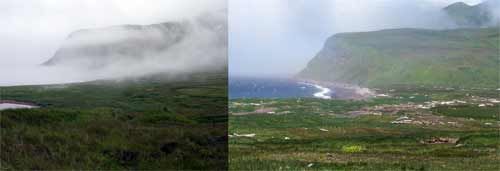 On Left: The field camp at Ainu Bay in 2006. You can see the relatively even beach ridges covered with grass.
* On Right: In this picture, which is taken in 2007 from a similar, but not identical perspective, you can see that the upper beach area is not pocketed with erosion features and the driftwood has been moved much further away from the beach. *

As we walked around the area, Bre and I were continually exclaiming "Holy Crap!”, "Wow!”, "Oh my Gosh!” or "Look at that!”
There were two features that we both thought were the most astounding of all, however.
The first was what we termed "The Scalped Hill”. As the tsunami wave flowed in, it encountered a small rise of about 2 meters in height. This slowed down the wave and then as it came over the top, it gained speed again. The hill was covered with a grassy turf of about 10-20 cm in depth that had grown on top of a thick layer of volcanic cinders. The wave had stripped back the turf at the level of the cinders and then rolled the turf over all along the up-beach side of the hill as the water flowed back along and around the hill. The hill’s head of turf had been "scalped” by the wave!

The second astounding feature was an erosional scarp that dropped about 3 meters down from the top of a beach ridge to below the original beach surface to a layer of large, rounded cobbles. The scarp was rather long, running at least 200 meters along the beach.

By this time, we were kicking ourselves for not bringing the nivelier and tripod. We could re-measure the profiles taken last year with the stadia rod and hand level, but the hand level is much less accurate than the nivelier. The hand level can only be read every 5 meters or so and has an error of as much as 1-2 centimeters with each reading. Over the total length of the profiles that were measured at Ainu Bay last year, 350-400 meters, the amount of error that would accumulate would be too great to make good comparisons.
So we had some decisions to make – earlier in the day, we had learned in our daily satellite phone call to the Captain of the Iskatel that there was a typhoon that would hit our area in the next 24 hours and that Jody and I would not be picked up on August 5 as previously scheduled. Instead, we would be picked up on August 8, after the ship picked up the archaeology group on Shiashkotan as the ship moved back south along the island chain and eventually back to Korsakov. So we had a lot more time on Matua, but we also had no idea what the weather might hold…
So we decided to at this point, that we would re-measure one of the profiles from last year – Profile 1 – only from the edge of the marsh grasses down to the beach. That way we could match up the points pretty closely to last year’s profile for comparison. Then, sometime over the next three to four days we would do our darnedest to get back over with the nivelier and tripod to re-measure and sample the longer and more easily-located Profile 2. This way we would at least have SOME thing to compare if we couldn’t get back, but would give us a good incentive to come back even if the weather was not "ideal”.
Bre and I measured the partial Profile 1 with the hand level and rod – making each measurement along the 50-meter tape twice so that we could calculate the error. Then we packed up our gear and about 25-30 glass floats that we had collected (out of the 50-75 that we SAW) and began the hike back to the camp.
We returned tired and worn out – ate some warmed up dinner of rice, beans and ground beef from the night before – had some tea to warm up, and headed to bed with the wind beginning to kick up in anticipation of the storm.
Da Svidanya! Misty
Comments