
It seems that I am still having trouble with the motion of the ship…I spent the evening of July 31 and the morning of August 1 in my bunk…. Bre gave me some of her Bonine though for motion sickness and that combined with smoother swell has made it so that by breakfast time, I was mostly up and around.
Today was a day of many plan changes. Originally, the plan was for us to spend one day at the Ushishir Group of Yankicha and Ryponkicha as we headed north toward Shiashkotan. Then the plan became to spend two days at Ushishir. I was slated to head to shore both days with Ben and Mike to do a larger test pit excavation at the archaeological site that Ben and I visited last year on the north end of Ryponkicha. It looked to be a wet cold day for a zodiac ride – as it was raining pretty hard and a bit windy.
At about 8:30 am, we began to see lightning and hear thunder – so the plans to go ashore were put on hold for an hour or so. At this point, Bre and I decided that we should take the opportunity to wash the dirtiest of our laundry – minus the field clothes that we were wearing, of course.
Shortly after we had washed the laundry and hung it about the cabin, we got word that Ushishir work had been postponed until we head back south at the end of the field season and that Jody, Bre, Tanya, Katya, Sergei and I were going to be put ashore on Matua that afternoon! Oh no! Now all of our clothes were wet! We quickly transferred the most urgently needed ones to the sauna to dry faster – the rest could dry onshore, if needed.
The plan was for all of us to set up camp and then for Jody and I to be picked up on August 5 to be transported to Shiashkotan, where the main group of archaeologists would be setting up a field camp to work at the Drobnyye site.
By 5:30 pm, we were waiting with our semi-clean, mostly dry clothing packed into bags and packs on the back of the Iskatel. Dima Frolov and Nikolai Vasilenko had been dropped off to do work at the GPSA Global Positioning System (GPS) is a satellite-based navigation system used to track the location or position of objects on the Earth’s surface. station near Ainu Bay, which is on the Okhotsk side of the island. Our camp was going to be on the Pacific side of the island, behind a moderately-sized, near-shore island wear the landing was a bit easier.
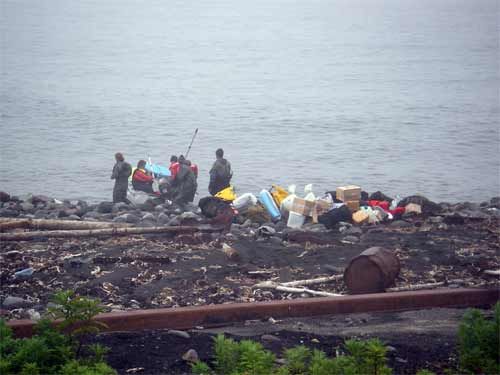 *
The zodiac brings the field gear to the shore of Matua. You can see some of the rusty military equipment that litters the shore. Much of the equipment is World War II vintage and some has been exposed by the erosion from the tsunamis caused by earthquakes in November 2006 and January 2007.*
*
The zodiac brings the field gear to the shore of Matua. You can see some of the rusty military equipment that litters the shore. Much of the equipment is World War II vintage and some has been exposed by the erosion from the tsunamis caused by earthquakes in November 2006 and January 2007.*
We quickly brought all of our gear ashore, set up the work tent near the shore and our personal tents up on the terrace where it was a bit more sheltered. Then we had a quick bite to eat of bread, cheese and sausage for dinner and headed to bed. Tomorrow, we would begin tsunami hunting!
Da Svidanya! Misty
Comments