
November 30, 2007, Friday McMurdo Station, Antarctica 11:00am High: +19F wind chill: +9F Low: +19F wind chill -3F Winds: E 8 knts; Station Pressure: 28.930” Present Conditions: overcast; light flurries picking up to gusty and more snowfall
Thursday afternoon we began collecting samples of the terrestrial environment. If you have read the previous postings, I spoke about the Antarctic Treaty. Recall that the treaty ensures the protection of the Antarctic environment. Environmental principals govern all Antarctic activities (Article 3). Activities should be planned and conducted to limit adverse impacts Activities be regularly monitored. Cooperation should occur in the planning and conduct of activities and sharing of information (Article 6)
One of the predominate goals of the environmental monitoring project is to Establish the "footprint" of the station and determine whether it is increasing or decreasing in size over time and in response to management decisions.
In order to do this a series of samples of soils from around the station are collected and analyzed. The contaminants that are tested include: total petroleum hydrocarbons (TPH) from petroleum spills or leaks and trace metals from metals - dust, solid waste disposal. The trace metals include aluminum, arsenic, barium, cadmium, copper, mercury, nickel, magnesium, manganese, lead, vanadium and zinc. In addition to these, polychlorinated biphenyls (PCB) and polynuclear aromatic hydrocarbons (PAH) are tested. The samples are collected at statistically random sites based on previous GPSA Global Positioning System (GPS) is a satellite-based navigation system used to track the location or position of objects on the Earth’s surface. determined sites. These areas include buildings, bulk fuel storage tanks, pipelines, roads, parking lots, helicopter pad, any areas physically disturbed areas as well as a control site off the station. The control site this year is at Cape Bird- a penguin colony that we will access by helicopter.
What we do… Andrew has run a statistical random sampling program based on the data points collected 8 years ago. From that, it tells him which specific points and sites need to be sampled. With a GPSA Global Positioning System (GPS) is a satellite-based navigation system used to track the location or position of objects on the Earth’s surface. receiver on his back he locates the exact spot of the random sample at each site. In most of the areas there are 16 samples from the random data points. He places a sampling jar at that point. The a 1 meter x 1 meter section is measured, photographed and Steve logs the point, the inclination, the depth of ground penetration, and then a jar of soil sediments is collected. This happens 16 times at each site. We will collect 280 samples this year for the terrestrial measurements. The samples are processed for shipping back to Steve’s lab in College Station and the tests will be run in the spring.
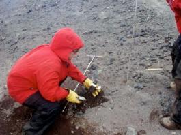
Ann collecting soil samples at the vehicle maintenance shop
Comments