Delays

    Today was another day figuring out how to manage the inevitable delays that come with field work in a place like the Arctic. We found ourselves navigating complex equipment, other unexpected delays, and just the challenge of trying to get all of the aspects of our work up and running.

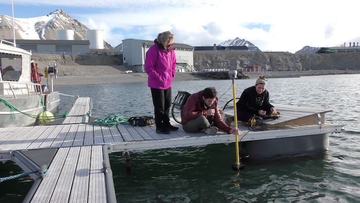
    Kelly has been valiantly spending the past few days trying to get the bathymetry (seafloor depth) equipment working properly. It’s a pretty complex system where a transducer sends a sound signal to bounce off the seafloor. Then based on the time it takes the signal to return, the depth of the seafloor at that point can be determined. At the same time, this all has to be connected to a GPSA Global Positioning System (GPS) is a satellite-based navigation system used to track the location or position of objects on the Earth’s surface. location and known elevation, which is done between two radio-controlled devices - one is fixed to the top of a building here in Ny Ålesund while the second is connected to the transducer. All of that information is sent to a handheld device which stores the data. Well, it’s been a huge challenge to get all of these devices to communicate with each other, and Kelly has been incredibly persistent! Knowing the seafloor depth is really vital to learning how the glacier is changing over time.
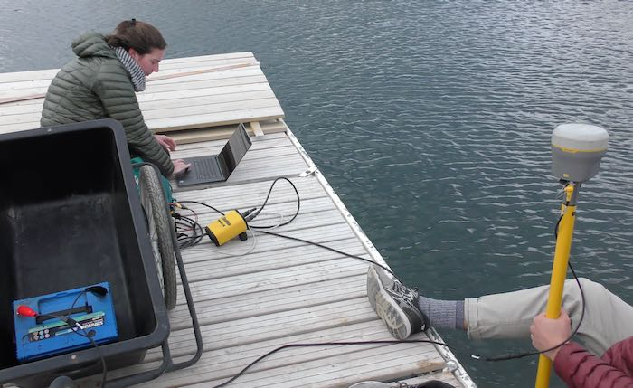
    Bathymetry test
    Kelly working on the bathymetry setup on the dock.
    Bathymetry test
    Another bathymetry test on the dock.

    Xander has been working on getting the current velocity meter and the CTDA research tool that is submerged in the water to measure conductivity (salinity), temperature, and depth. instrument up and running. The CTDA research tool that is submerged in the water to measure conductivity (salinity), temperature, and depth., which stands for “Conductivity, Temperature and Depth” is designed to help us measure the salinity (from electrical conductivity) and temperature and various depths. This device is also equipped with a turbidity sensor which can measure how turbid, or cloudy, the water is. (This is valuable for knowing how much sediment is in the water.) While these devices are simpler to operate than the bathymetry system, they still require time to get set up properly and learn how to operate.
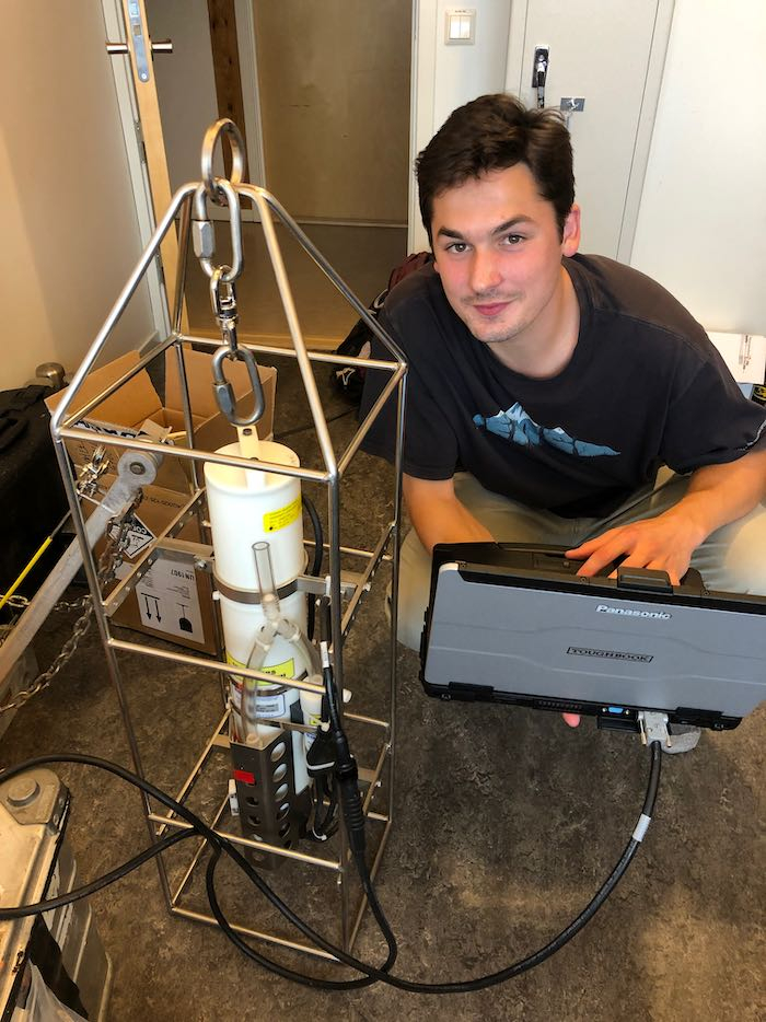
    CTD setup
    Xander working on getting the CTD setup ready for data collection.

    Julie is, of course, the chief scientist. In that role, she is spending her time coordinating, guiding us, and networking with others outside our group. She also has to interface with the wonderful logistics and scientific personnel here at Ny Ålesund - whose help we need to do the work. Julie has the ability to see the big picture of her research while also figuring out how to deal with all the minutia needed to get this project off the ground. I’m amazed at how well she navigates all of the hurdles the group has already faced, by maintaining her patience and good sense of humor. She is also a true collaborator, and has spent a lot of time talking with other scientists to find areas of collaboration.
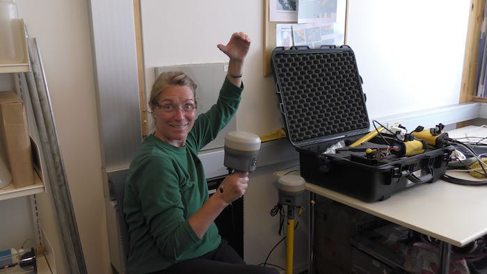
    Julie Brigham-Grette in our office space
    Julie poses with the bathymetry head. As always, keeping her great sense of humor!

    My main job will be flying the drone. Over the past couple of weeks I had to work on getting permission from various people to make sure I have the authorization to be able to fly. A big part of this is because Ny Ålesund is a “radio silent” area. There are several ongoing experiments which use radio frequency waves, so wifi, bluetooth and other radio frequency bands are generally not allowed within 20km of the research base. However, with special permission you are allowed, but even then you are restricted to certain times when experiments are not going on, and when the airport is not communicating with planes (which generally happens twice a week).

    So I had to get permission from (a) the Norwegian Civil Aviation Authority, (b) NKOM, which is the equivalent of the Federal Communications Commission, (c) the Governor of Svalbard, (d) the Norwegian Mapping Authority, and (e) the Ny Ålesund Airport. I was able to get all those permissions, so now I am able to fly the drones up here. A huge shout out to Vera at the Norwegian Polar Institute and Stian from the Airport for being so helpful in guiding me through this process!

    There are other logistics to work out. We had to get our survival suits rented and we will get our boat tomorrow. We will need to get assistance mounting equipment to the boat (like the winch to lower and raise equipment into the water). And today we found out a new law requires us to get a gun license from the Norwegian government in order to rent rifles - apparently that law literally went into effect on July 1, while we were in quarantine! Anyway, we are trying to expedite this process. Hopefully we’ll have our gun licenses in hand within a day or so. The problem is that we can’t go anywhere outside of Ny Ålesund without a rifle (because of the risk of polar bears). Without rifles, we’d be stuck!
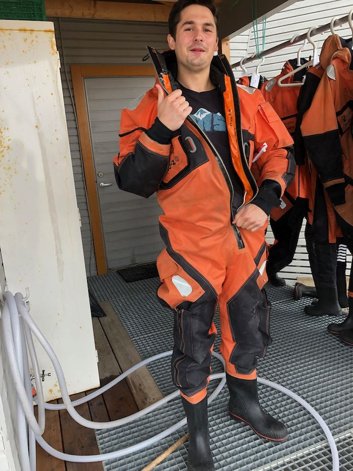
    Survival suit
    Xander trying on a survival suit
    Survival suits
    Survival suits hanging up to dry. If you know me, you can probably figure out which is mine.

    Opportunities

    One of the wonderful things about being in a place like this are the amazing opportunities for collaboration between scientists. Everyone here is either a scientist or someone here to support scientists. The first question you ask (after “What’s your name?” and “Where are you from?”) is always, “What science project are you working on?”

    There are people studying all sorts of things here - in addition to glaciers, there are scientists studying how kelp (seaweed) is changing as a result of warming oceans. There is a group of scientists studying bird populations and behavior. There is a group studying how to use satellite and drone images to help clean up plastic along Arctic beaches. There are ongoing projects using radio telescopes to make very precise maps of the Earth and to detect subtle changes in the Earth’s structure. And ongoing projects monitoring of the atmosphere. With over 100 people here right now, I'm sure I have missed many projects in this list; we just haven't been here long enough yet.

    We’ve been talking with a large international group of scientists who are doing amazing work on the same glacier system we will be studying. They are monitoring all sorts of things about the glacier to detect how meltwater collects and flows through the glacier. Some of the equipment they are using include seismographs, CTDs, time-lapse and drone photographs, and these very cool sensors that will be put into meltwater pools on top of the glacier and (hopefully) flow out channels that develop. Since these sensors are GPSA Global Positioning System (GPS) is a satellite-based navigation system used to track the location or position of objects on the Earth’s surface.-enabled, hopefully the pathways of the meltwater channels can be mapped.

    Some of our work overlaps or complements what they are doing, so there is not only an opportunity to share and expand on each others’ work, but on a practical level we might be able to join them out on the fjord. (Which will also be helpful if our gun permits don’t come through!)

    Another group that might be interested in collaborating is the group studying kelp. We are monitoring the outflow of sediment from the glacier, and the flow of sediment into the fjord can have an effect on the ability of kelp to photosynthesize. I’m reminded of how interconnected all the parts of the environment are, to think that changes in a glacier can affect kelp miles away.

    We also had one of the bird researchers offer to come with us since he already has his gun permit. So there is a really great sense of camaraderie here!

    It’s so exciting for me to listen to all these different scientists talk about their work, and you really get a sense of how much more successful and interesting scientists’ work is when they have opportunities to collaborate with each other. I think of it like cross-pollination - the more that scientists can work together, the more we all learn and science will flourish!

    Wildlife Sightings

    While we spent most of our day inside, we did get two wonderful wildlife sightings. The first was a polar bear sighting, just outside of town. Here’s a video I took of a mother polar bear and her cub.

    Then this evening we saw this great scene of an Arctic fox hunting Barnacle Geese, while it was being harassed by Arctic Terns!

    Author
    Date
    Location
    Ny Ålesund, Svalbard
    Weather Summary
    Mostly Cloudy
    Temperature
    5°C (41°F)

    Comments

    Giorgos

    Hello, hope you're having fun in "Ny Ålesund, Svalbard". I was shocked when I read about the crazy things that the CTD can do. I was wondering about the importance of the CTD instrument. I understand what the instrument's job is to help measure the salinity (from electrical conductivity) and temperature and various depths. This device is also equipped with a turbidity sensor which can measure how turbid, or cloudy, the water is. I was wondering why you would need to know these things while your research topic is to understand more about the climax of climate change and more about how climate change affects the icebergs. In conclusion, how does the information given by the CTD instrument help you with your research topic/question(s)? I believe that it might be it's ability to read temperature which can let you know when more icebergs have fallen into the ocean which tells you when most icebergs fall off and the temperature is the warmest. This might help you build on your research about the speed and time in which icebergs fall in the ocean more commonly.

    Mark Goldner

    Hi Giorgos, great to hear from you! I'll be going into more depth (no pun intended) about how the CTD works and how it helps us answer the big research questions. But basically what the CTD will give us is a better understanding of how the water moves into and out of the fjord. We are most interested in the subglacial jets - the water flowing under and out of the glacier. By making measurements of temperature, salinity and turbidity at different depths, we hope to be able to map how that water is flowing in front of the glacier. Also, we hope to be able to see the differences between water coming off the glacier (colder, very sediment-rich freshwater) and water coming in from the ocean (warmer, clearer, saltwater). Since Dr. Brigham-Grette has data from several previous years, we might be able to see how the water patterns are changing over time. All of this will help us understand how the whole glacier system is changing due to climate change.

    Charlotte Pappas

    Mr. Goldner,

    Foremostly, it was interesting reading this post, and learning about what other groups of scientists that are also staying at Ny Ålesund, Svalbard are studying. I was particularly intrigued about the scientist group that is studying how climate change is affecting and changing kelp in the Arctic. For example, I know that kelp is a very important organism in the Arctic food chain, as it is one of the primary food sources for many Arctic animals, such as various species of fish, abalone, and sea urchins. Therefore, I think that it is necessary for us to understand what aspects of climate change are affecting kelp, so that way, we can learn what actions to take to help protect kelp, which would allow animals in the Arctic continue to survive and thrive in their environment.

    In addition, I am also intrigued by the video you posted of an Arctic fox hunting some Barnacle geese. This is because when watching the video, I could see that the Arctic terns that were flying by were trying their best to distract the Arctic fox, which made it not able to harm any of the Barnacle geese. Moreover, this video makes me further wonder if the Arctic terns were purposely trying to distract the Arctic fox from hunting the Barnacle geese, or were they just flying by, and the Arctic fox got distracted, and do Arctic terns and Barnacle geese have an mutualism or commensalism relationship with each other?

    That is all of my thoughts for now.
    Charlotte

    Mark Goldner

    Hi Charlotte, great questions as usual! I don't think there is any kind of symbiotic relationship between the terns and the geese. But the terns are heavily preyed on as well by the foxes, so I am pretty sure they were just acting to protect themselves from the foxes.

    Ytien Liu

    Hey Mr. Goldner! Hope you're having an amazing time in Ny Ålesund. I was fascinated seeing all the videos you had on the wildlife there. I was also surprised to hear that another group was learning about kelp. In addition, this led me to my questions- does the kelp affect glaciers? I've heard kelp is a very important factor of the food chain as many organisms feed on it. Another question, do you know what would happen if glaciers disappeared?

    Mark Goldner

    Hi Ytien, thanks for your interesting questions! I don't think the kelp has an effect on the glaciers, but the glaciers can have an effect on the kelp. You see, kelp need rocks to hold fast to in order to grow, and glaciers that flow quickly - like Kronebreen and Kongsvegen - release so much loose sediment that they will inhibit the growth of kelp. One of the things that might happen in the future, is that when those glaciers retreat back on to land, the amount of sediment they release may drop. This may leave more exposed rock allowing more kelp to grow. Because, as you say, the kelp is a key part of the food chain, this could have big impacts on the ecology.

    Another interesting thing related to kelp is algae that can grown on glaciers. This algae is darker in color than the ice, which can absorb more energy from the Sun, which in turns could cause more melting of the glaciers. So it would be interesting to know whether a warming climate will allow more snow algae to grow - this could cause glaciers to retreat even faster.

    Max Gallentine

    I'm so sorry to hear about your delays, but I am really interested in learning more about the equipment used for measuring the seafloor depth. Specifically, the bathymetry piqued my interest, and reading more about it immediately reminded me of the echo location. As for the wildlife, I didn't know that a fox could be harassed by such a small bird! Was that the only fox you had seen on your trip? regardless of your answer how many do you think could be in the arctic? (estimation of course) As for the polar bear, what a cute video although that polar cub was really lagging behind. (I also feel the need to add how surprised I was when you zoomed out!)

    Max G.

    Mark Goldner

    Hi Max! I'm glad you're enjoying the blog. The way the bathymetry equipment works is through sonar. A beam of sound (you can hear it!) is sent towards the seafloor every second, and when it reflects back, the echo is recorded. Based on the time it takes for the sound to return (and knowing the speed of sound in water) the device calculates the distance the sound travels. It's the same principle by which bats and dolphins navigate through echolocation. Our bathymetry device is also connected to a GPS unit, so the GPS location is then tagged with a depth.

    We've seen several foxes so far in Ny Ålesund. They like to hang around here because there are a lot of geese and Arctic Terns nesting in this area which they prey upon.

    Yes, I am lucky to be borrowing such an amazing video camera with such an incredible zoom! It helps me really see some great wildlife up close.

    Maya Silk

    Dear Mr. Goldner,

    I am very sorry to hear about the delays and difficulty with equipment you are having. While I was reading, I found one type of equipment called bathymetry equipment. I had a few questions about the bathymetry equipment including, how accurate is the equipment and are there other ways to get the same information by using less, more effective devices. I also wonder why it is important for scientists to know the depth of the sea floor. Thank you so much for sharing your experience.

    Sincerely,
    Maya S.

    Mark Goldner

    Hi Maya, you are asking really important questions! The equipment is actually relatively simple; we chose to use this particular system because it's light and portable. There are other bathymetry systems which have much better resolution, but they are much larger and less portable. Knowing the seafloor depth can be useful for many types of research. In our case, we want to understand better how the water in the glacier is moving, and how that might change over time. Since the water is full of sediment, we think that mapping the seafloor might reveal sediment deposits in front of regions where there is more water flowing off the glacier. In addition, there are other features created by sediment that can change if the glacier retreat accelerates (or slows down). So knowing the seafloor depth can help give a more complete picture of how the glacier is changing over time.

    Chelsea Koehler

    Hi Mr. Goldner! It sounds fascinating (and fun!) to visit Ny Ålesund. I though the videos of the polar bear and the fox were especially cool. Did you see wildlife like that often, or just a few times that you recorded? I also think it's interesting how many scientist were there. It must have been entertaining to learn about all the other experiments going on there. One last question- How does global warming affect the kelp? As in, what happens to the kelp or what changes about it?

    Mark Goldner

    Hi Chelsea, thanks for your comment and questions. We only saw polar bears a couple of times, but we saw foxes and reindeer pretty frequently. We also saw seals quite often.

    You are right, that it's a great experience to share ideas and experiments with other scientists. For example, the kelp research you refer to - we were able to think about how the melting of the glaciers might affect the kelp population, and therefore the entire ecosystem that depends on kelp and other algae at the base of their food web. As to your specific question: Kelp is a type of algae, and algae (like plants) survive in very specific conditions. As those conditions change, it can affect how kelp survives. The researchers actually think kelp population may increase in the fjord as the climate gets warmer. This is because they do better in water that is less turbid (clearer) and has more rocky seafloor. As the glaciers recede up onto land, there will be less sediment flowing into the fjord which will clear up the water. In addition, more of the rocky base of the seafloor will be exposed, which provides a rocky surface on which the kelp can grow.

    Micheal Siedlecki

    Dear Mr. Goldner

    I was very interested in how the last time you visited the Arctic, you were able to go in the ocean. My question is were you able to go into the ocean again, and if so, was the temperature any different.

    From Micheal

    Mark Goldner

    Hi Micheal, no we weren't able to go back into the ocean this time. We were just too busy, and we also didn't have a day where we felt the air temperature was warm enough to make the experience tolerable!