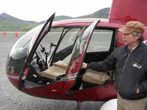
I was full of nervous anticipation as I climbed into the tiny helicopter. The door frame seemed so fragile and the nose so small and close to my feet. I hoped it would hold me. The blades were whirring above us and the whole thing started to shake. Suddenly the gravel in front of us started to drop away and we lifted 50 feet and kept climbing. We were airborne!
The day started back in Kotzebue where packed up our gear and moved it all to the the airport. When the pilot of the Cessna 208 Caravan saw our pile of plastic bins, dry bags and wood archaeologist's soil screens he said, "We're going to need a bigger plane!"
In the end we all fit. There was Ines and Stephan - young archaeologists from Germany, Ian the college professor from Oregon and Steve our base camp manager. We climbed out of Kotzebue in the single-engine plane but stayed low under the clouds. I noticed we were flying at about 800 feet for most of the flight, zooming along over rolling green tundra, clear green rivers lined with gnarled pines and brackish lakes the color of coffee. We landed between two mountains at the Red Dog Mine. From there we would go the rest of the way in the little red helicopter.

The helicopter pilot Stan Hermens flew in soon after we unloaded. Because only two passengers can go at once, we took turns. I ended up going on the last flight with Bil Hedman, chief archaeologist on the site. We had earlier sent a "sling load" which was 544 pounds of gear in a big net. I helped calculate the weight. It's really important to know the exact weight because the aircraft has specific limits.
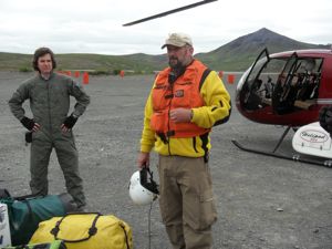
To fly for the BLM in the helicopter we had to have gone through the aviation training, and we had to wear fire-resistant flight suits. Together with the army-green flight suits and the Nomex flight gloves and big white helmets, we look like Maverick and Ice Man from Top Gun. Highway to the Danger Zone! I was pretty excited.
After we lifted into the air from the Red Dog Mine airstrip, we curved over to the right and Bill suggested we go out between two peaks. He wanted to go scout out and find some snow or ice we could use in our coolers. Soon we were cruising through bright green mountain valleys with clear streams rushing through rocky grottoes. There were perfect little waterfalls and deep, teal-green swimming holes. Helicopters are so much faster than hiking! Usually it would take hours to see what we saw in 15 minutes. Passing over one saddle between peaks I spotted a brown creature - caribou! Soon I saw another walking up a ridge. Wow! Stan and Bill found a great patch of ice to use later so Stan marked the spot with a waypoint on his GPSA Global Positioning System (GPS) is a satellite-based navigation system used to track the location or position of objects on the Earth’s surface. to return to. We swooped to the left up a grand valley with a wiggly river below- I recognized our camp in the distance. What's that brown thing to our left? Bears! A big sow momma and her two little cubs - right below my window 150 down! The mom looked up at us but her cubs went sprinting away up a hill and then mom followed. "That's right, you're going the right direction," said Stan into the headset. "Away from our camp."
Soon we were dropping slowly toward our yellow tents on the gravel bank. Stephan and the team were heading up to the dig site carrying loads of gear. He smiled. A bird careened over head on this white wings - an Arctic Tern! The mascot of Polartrec. These graceful yet tough fliers travel from the Antarctic to the Arctic annually. Wow!
I set up my tent just 10 feet from the babbling Kivalina River which wanders the 35 miles or so down to the village where our students will come from. Then I hiked up to the site to have a look.
We started by removing the turf squares that had been replaced in last year's dig. They had been filled back in with carefully screened soil and big rocks. Ian wanted us to dig out the old units to he could draw the stratigraphy (soil layers). We shoveled hard for two hours to get to the bottom of the old pits. Mosquitoes swarmed us as we heated up. There might 10 or 15 on one person's back at once. At the bottom we found large green flakes of chert - pieces left by tool workers many years ago. Who knows how long they had been buried!
Then I spotted a brown and white piece in the un-searched soil - a caribou tooth! I was pretty excited though all the experienced diggers took it in stride. I hope they will check its age with carbon 14 dating and discover it's very old.
Later on the rocky ridge looking over the river below, Steve showed me where ancient flakes were left by tool makers many years ago. I searched carefully, stooping low, and found a piece like a big arrow head broken in half. It looked like the tip of a spearhead. I showed it around and the veterans agreed it had been "bifacially worked" (carefully shaped on both sides to make a sharp tool. As it turns out, things like this are simply put back where they were found. Their long history in this beautiful valley can continue.
Looking out across the vast green expanse I could almost picture lumbering brown mammoth moving in groups. It's so excited to finally be in our field camp!


Comments