
Jack’s weather report:
It’s another beautiful morning in Barrow. The sun is up, of course it always is now, and shining bright. No clouds that I can see.
Temp: 35 °F
Winds: light out of the east
Happy Father’s Day to all the fathers out there, including mine, Hugh Wilder, who is back in Spartanburg, SC.
Yesterday was a busy day for me and a tiring day.  It began with a 53 minute run around town, definitely my furthest venture around town since I got here.  It was warm enough so I was able to run in shorts and no hat.  I did wear light gloves and a long sleeved shirt.

Once back at BASC I cleaned up and ate breakfast.  It was the usual for me, cereal with raisins, French toast, bacon, and a banana.  After breakfast I met with Adrian, who is a student from UTEP.  He is mapping the area as part of the entire biocomplexity project.  I was very interested in how his mapping system worked.  Here are some photos of the systems that he uses, which is satellite <span class="tx-tooltip" tabindex="0">GPS<span class="tx-tooltip-text" id="polartrec_vocabulary-1417">A Global Positioning System (GPS) is a satellite-based navigation system used to track the location or position of objects on the Earth’s surface.</span></span> to mark the positions of everything within the BEO and anything else he wants to position.
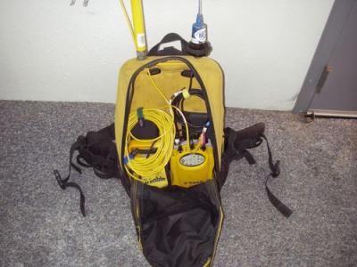
Here are the guts of Adrian's GPSA Global Positioning System (GPS) is a satellite-based navigation system used to track the location or position of objects on the Earth’s surface. unit.
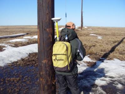
Here's Adrian positioning one of the poles going out to the biocomplexity site found in the BEO.
This morning we were simply mapping the power poles that take electricity out to the biocomplexity site. Here is a picture of Adrian standing next to one. He has to get a close t the pole as possible and then position it. <span class="tx-tooltip" tabindex="0">GPS<span class="tx-tooltip-text" id="polartrec_vocabulary-1417">A Global Positioning System (GPS) is a satellite-based navigation system used to track the location or position of objects on the Earth’s surface.</span></span> is not perfect and has an error factor that must be corrected. This is typically done by adjusting your position to something with a known position. There is a receiver at BASC that has been constantly positioned for a long time. Adrian thought it was something like 30 years. At each pole Adrian acquires the satellite to position the pole. This is then corrected for any error by comparing our position to the know position at BASC just a couple miles away. I helped by taking pictures of each power pole to match the positions.
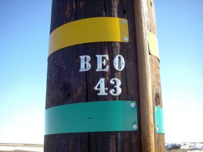
The poles are clearly marked going out to the BEO, Barrow Environmental ObservatoryA location used for observing terrestrial and/or celestial events..
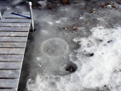
I also took time to check out our sampling plots to see if more had opened up from the ice. This picture shows a site that is completely open. The ring is where the CO2 chamber makes a seal for us to take our measurements.
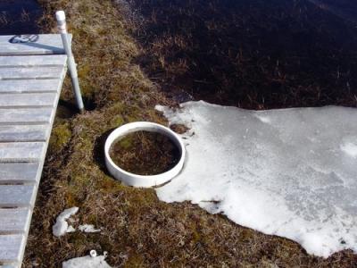
The above chamber plot is ready to measure the NEE. (Net EcosystemAn ecological community together with its environment, functioning as a unit. Exchange)
Other plots are not so ready
This plot has some thawing to do before we can make our measurements.
After lunch we were able to find the working wireless from the college just next door and I could post yesterday’s journal entry. Dinner seemed to come quickly and then prepared to head back out to the field. This time it was to show Jason, our newest member of the group, the biocomplexity site and to do some programming changes to the datalogger. The phalaropes were quite active and several females were fighting over the rights to a single male. The females have to more distinct coloration in phalaropes and will mate with different males and the males actually care for the young, so the sex roles are reversed.
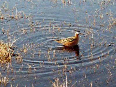
Phalarope (female)
We didn’t get back until 10:00 p.m. and I was beat. I slept very soundly. Today I am looking forward to our first actual measurements taken in the field.
Comments