A Typical Day

    Now that I have been here for several days I can provide an accurate description of what a typical flight day is like.

    5:30 am - The flight crew mechanics open up the plane and begin preparing it for takeoff. If the temperature is below 0ºF they will have to deploy the diesel powered engine heaters to warm the P3's four engines prior to start up. They do a walk-around working through a standardized checklist, paying close attention to wear parts (tires, engines, etc.). This will take the entire crew (pilot, co-pilot, flight engineer, mechanic/safety officer, ground crew) until nearly 8 am.

    6:00 am - By now everyone who is going on the flight will be awake. My goal is to get dressed, eat breakfast, wash my dishes, make and pack a lunch, and then pack my backpack for the day, all by 7 am. Things I take with me include my laptop, cameras, notebook, and warm clothes. I also bring Flames (dragon) and Dusty (muskox), my kids' two stuffed animals that were specially chosen to join me in Greenland. The warm clothes are necessary as the temperature inside the plane can vary quite a bit. I've worn just a t-shirt at times while others I've needed the whole wardrobe: fleece, down coat, and hat.

    6:30 am - Over at the Metereological Office our navigator/amateur meteorologist (Jon Sonntag) and team leader (Michael Studinger) go over the latest weather information and finalize our flight plan. There are about 72 routes to fly in Greenland but only time for 50 or so. They have to prioritize which routes are most important, determine which routes have good weather, and keep track which routes remain as possibilities.

    7:00 am - I start the walk over to the airport. It's about 7 minutes one way to the plane. I can hear the APU (auxiliary power unit) running as soon as I step outside. My commute takes me past the colorful residential buildings of Kanger. In much of Greenland the locals have taken to adding color to their otherwise grey scale surroundings by painting their buildings brilliant pastel colors.
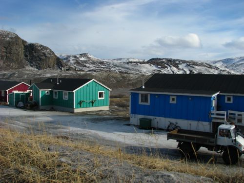
    Buidings in Kanger
    The colorful palette of Kangerlussuaq.

    7:30 am - Everyone who is going on the day's flight must be on board by this time even though the plane will not leave for another hour. I hang up my backpack with a carabiner and prepare my cameras. I settle in to my favorite seat which is in the very back next to Jim Yungel, a veteran ATM (airborne topographic mapping) scientist. He runs one of the two lasers that determine the height of the surface of the ice and seems to be an endless database of knowledge regarding all things related to OIB. Jim has been doing this longer than anyone else on the plane. Jon, the navigator, posts the day's flight plan on a wall inside the plane. He has three colored maps that depict the route for us. Inside, a plane-wide internet allows each scientist to follow the plane on a map, access the nose camera, and view a nadir camera (pointed straight down), among other things.

    8:00 am - The doors close around this time and the ground crew pulls the stairs away. The flight crew starts the engines and allow them to get up to temperature before taxiing. Everyone buckles in at this point.

    8:30 am - By this time we have taken off. The taxiway is short and there is never any air traffic to deal with. Our takeoffs are to the west, down-fjord.

    8:30 am - 4:30 pm: Flying. We don't land during this time and there are only about 4 or 5 airports in Greenland that we could land at if we needed an emergency landing strip. People nap on top of the padded engine covers on a rotating basis. The scientists monitor their instruments during the flight but most need little attention. When conditions change - clouds show up or we notably alter our altitude - then they'll need to make adjustments. Before landing we often fly over the ramp at the Kanger airport as a means to calibrate the the ATM and the DMS (digital mapping system - basically our digital cameras) devices.

    4:30 - 5:00 pm: Hard drives are removed from the plane and packed in waterproof cases. The engines run another 4 minutes to cool them down before they are shut off entirely. The navigator and team leader drive over to the meteorology office for another weather briefing. And the ground crew spends about 2 hours maintaining the plane and preparing it for the next day. I try to make it to the one grocery store in town to purchase food but I have only made it once in the week that I've been here. They close at 5 pm. If I can't get groceries then I have to survive on the equivalent of convenience store rations. Not ideal.

    6:00 pm: Everyone meets in the upstairs lounge at the KISS building (our dorm) for a science meeting. Michael Studinger (team leader) reviews the day's progress, Jon (the navigator/weatherman) goes over the tomorrow's forecast and possible routes are discussed. We develop the flight manifest for the next day - who's flying, who's not. After all questions are answered the meeting is adjourned.

    Following the meetings nearly everyone seeks some form of dinner and about 90% of those seeking dinner go to the one restaurant in town (the Polar Bear), two doors down from the KISS building. The Polar Bear serves pizza (passable), Thai food (quite bad), sandwiches (survival rations), and a few other assorted items. Nothing they serve rises to the category of "good food," but with good company you can be distracted enough to swallow it down.

    Summit Station

    Along today's route were three passes in the vicinity of Summit Station, the permanently staffed research facility located at the highest point in the country, about 10,500' in altitude. In 1993 workers there completed drilling through more than 3 km of ice, finally reaching bedrock.
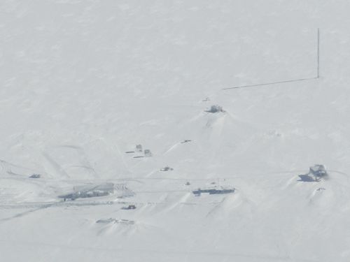
    Summit Station
    Summit Station as viewed from our plane. The "big house" is in the lower right hand corner. It's the main common area which includes offices and a galley.

    Today the station has a staff of around 60 during the summer and about 5 during the winter. The facility is an important base for all kinds of polar science: climate studies, albedo measurements, subglacial lakes, arctic clouds, pollution, etc.
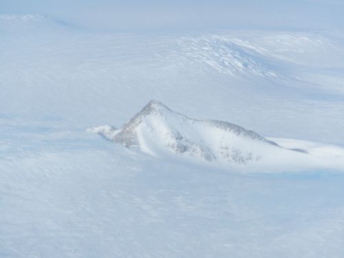
    Nunatak
    Nunataks are peaks that stick out of the ice sheet. Then tend to more pointy than other mountains because they escape the glacier's erosional powers.

    Going to the Dogs

    Walk half a mile west from the KISS building and you drop down on to the mudflats at the very head of the Kangerlussuaq FjordA deep U-shaped valley formed by glacial erosion, which is filled with seawater as the glacier retreats.. Here, the glacier-smoothed bedrock melts into miles of mudflats comprised of glacier-ground rock. A few more miles west and the mudflats give way to salt water - the fjord itself. Continuing westward, follow the fjord for 100 miles or so and you are out in the open ocean - finally.

    But down on the mudflats on the west end of town, not far from the runway, is Kanger's sled dog lot. Unlike Alaska where each owner has their own kennel, here all sled dogs are kept in a fenced lot on the outskirts of town.
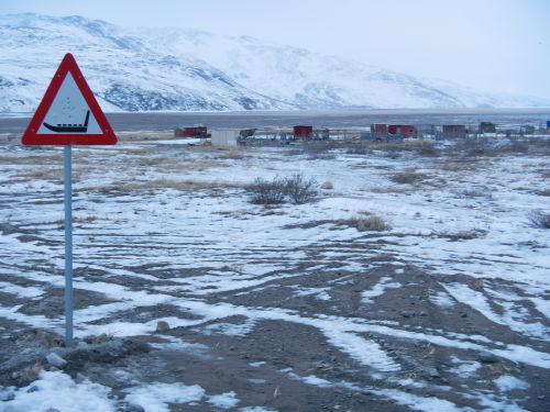
    Sled dog crossing
    You don't see these caution signs everywhere. Snowmachines are not nearly as prevalent here as they are in Alaskan villages. And so dog sled teams are used for work purposes more often than not. Leading out of Kanger are well-worn dog sled trails heading out the ice covered fjord to the west and into the hills to the east.

    After dinner I fought a cold, stiff wind and made my way down there to investigate. The dogs are officially Greenlandic huskies, a heavier, furrier breed than most Alaskans use. They are raised from the beginning as work dogs and will be treated as such their entire lives (i.e. no petting). I saw several teams chained up in various pens as well as a few strung out as if ready to run. For whatever reasons the puppies were allowed to run loose.
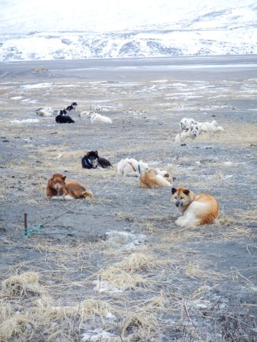
    Dogs on a chain
    These dogs live chained up out in the open waiting for the next trip.

    The wooden sleds are heavy enough to hold a pile of dead seals, a muskox, or a few reindeer. They are lashed together not with nails or screws, but with twine so as to maintain their flexibility. The dogs are attached in a fan-like formation in front of the sled, again different from the linear arrangement used in Alaska. All of the dogs looked looked well fed and none of them howled while I was there.
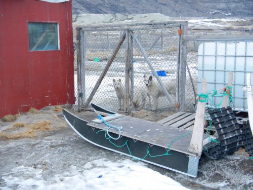
    Sled
    A typical Greenlandic sled with a couple of pullers-in-training.

    Question of the day: Our average air speed is 250 knots or nearly 300 mph. If we fly for 8 hours at this speed how far have we gone?

    Harder question: The scientists collect about 2.5 Terabytes of data during an 8 hour flight. How many bytes of data per second do they collect on average?

    Author
    Date
    Weather Summary
    Partly cloudy, windy
    Temperature
    10
    Wind Speed
    15

    Comments

    Russell Hood

    Stan-
    The sled dogs are fed mostly seal, maybe some muskox, and some fish.  I
    don't get the impression that fish is the main part of their diet as it
    is in AK.  The locals will use the dogs to go hunting - it almost seems
    pretty cyclical doesn't it?  Presumably there's enough meat leftover for
    the humans.  I'm not sure the extent to which locals fish - but I
    imagine they do a fair bit but I see no evidence around town of nets or
    boats.  (That stuff is likely several miles away from town, down fjord,
    by the open water.  However, we've flown over that area a lot and I
    still don't see much fishing gear.)

    I don't think there's much bonding to humans.  If a dog doesn't perform
    well it likely will either be killed or left behind.  It's pretty
    brutal.  I'm not sure if that happens that often, but I know it does.

    I doubt seriously that there's a vet around.  The solution would likely
    be to kill a sick dog and bring in a healthy younger one.  Survival of
    the fittest, for sure.

    We can walk around the plane nearly the entire flight, weather
    permitting.  The turbulence we hit is definitely more violent than
    anything you'll experience commercially.  I'm writing in the plane now
    and about an hour ago we hit one huge "bump" that left the science team
    leader airborne about 20" off the deck.  He was napping, unrestrained
    atop the engine covers.  I was looking down the plane, holding on tight,
    when it happened so I got a great view of it.  His landing was soft,
    fortunately, but it was one massive jolt.  Other gear went flying:
    laptops, water bottles, etc. but nothing was damaged.

    I wear noise cancelling headphones about 98% of the time.  The ambient
    dB level is around 90 inside the plane - it's pretty loud.

    For the most part these folks on board aren't writing papers, they're
    just gathering the data and making it public for other scientists to
    use.  It is an unquestionable truth that Greenland is losing ice -
    prodigious amount for sure.  It is also unquestionable that the rate
    with which that is occurring is speeding up notably.  To cite some
    numbers I just saw: The Jakobshavn Glacier alone has gone from losing
    about 6 cubic km per year to about 24 cubic km per year between 1997 and
    2009.  It is thought that it is currently now losing almost 100 cubic km
    per year!  That amount alone is incredible, and this is just one glacier
    in all of Greenland.  The only location they've noticed any thickening
    has been near the summit ridge that extends down the spine of the
    island.  But this thickening has been modest and does not come close to
    replacing the accelerating ice loss due to melting and calving.

    On 4/14/14 12:22 PM, webmaster@polartrec.com wrote:
    >

    Russell Hood

    Hi Sarah - thanks for writing:
    I'd have to say that overall Greenland is colder than AK.  Along the
    southwestern coast you can find locations that have weather similar to
    Anchorage, but that's the warmest you'll find here.  Every other
    location will have a more severe climate than that.  And since most of
    the island is covered with ice, the temperatures there can be downright
    frigid.  About 5 days ago we flew of Summit Station - a research
    facility on the top of the ice cap - and the morning temperature was -54
    Celsius!  I bet that no place in AK had a temperature that low that day.
     For the rest of my time in Kanger the temp is supposed to vary between
    about 2F - 20F: still much colder than Anchorage right now.  And Kanger
    is nowhere near the coldest place in the country.

    On 4/14/14 10:43 AM, webmaster@polartrec.com wrote:
    >

    Russell Hood

    Victoria-
    The routes are prioritized during a meeting at the beginning of the
    season.  Climate scientists have a large amount of input as to which
    routes they'd like to prioritize.  The list includes so-called
    "baseline" missions - ones that must be done every year to continue the
    time series of data.  Everything else is secondary to these.  Once that
    list is compiled the next variable is weather. What is the weather going
    to allow us to do?  Some days we will not fly due to the conditions.
    That generally means one less mission that will happen.  If there are
    some very important data points that we need to get they can be tacked
    on to a nearby route if necessary.  The SE coast is notorious for the
    nastier weather so whenever that is "open" we'll make a run there.

    I hope this answers your question.

    On 4/14/14 4:11 PM, webmaster@polartrec.com wrote:
    >

    Russell Hood

    Ashley-
    I suppose it depends on whether you're asking me, personally, or the
    scientists on board.  There are aspects that I definitely can get tired
    of: we show up at the plane by 7:30 but don't take off for another hour.
    We also have long stretches of flight where all you see is endless white
    in every direction.  But those times are useful for other things like
    writing email responses, which is what I'm doing now (so there's endless
    white out the window right now...).

    I think the crew probably gets tired of the same routine every to some
    extent, but the windows are there to remind you that you are in a pretty
    exotic location.  It should be said, too, that they are all very well
    trained, incredibly bright people who take their job very seriously.
    You get the sense that you could build a spacecraft from spare parts
    with just these people on board and open access to a junkyard.  Suffice
    to say that all of them took their education seriously and enjoy what
    they do.  Studying hard does pay off!

    On 4/14/14 3:09 PM, webmaster@polartrec.com wrote:
    >

    Guest

    Hello Mr. Hood. This is Alicia E. from los coaches creek middle school. I have a question. Why is there 60 workers in the summer but only 5 in the winter? Thank you

    Russell Hood

    You are referring to Summit Station, the research facility located at the top of the Greenland Ice Sheet.  The reason for only 5 is simply that they don't do much science over the winter given the harsh weather (between -50 to -90 C).  Those people are there to keep the station functional and maintained, but they likely are not doing much science.  At a minimum they will take extensive weather data each data, including the middle of the winter, but they will not be venturing out on the ice to drill cores or things like that.  Those can wait for the comparably warmer summer.-Mr. Hood

    Guest

    Hello Mr.Hood. This is Olivia L from Los Coches Creek Middle School. I have a question. To be exact how many checks are or the check list if it takes the whole crew to do check the plane? Thank You

    Guest

    Hello Mr.Hood. This is Olivia L from Los Coches Creek Middle School. I have a question. To be exact how many checks are or the check list if it takes the whole crew to do check the plane? Thank You

    Russell Hood

    Olivia-I have to ask our flight crew the answer to this one.  But the preliminary answer is that they go through a four page checklist that contains about 50 different items.  But many of those items have subcategories beneath them so there are more than 50 things to check.  Our flight crew begins preparing the plane 2 hours before we fly, if that gives you a better idea.-Mr. Hood

    Guest

    I recall walking the road from the airport to town on our layover there. What else is there to do? Good idea going to the glacier...we didn't have time for that. I guess they are all small after this, unless you go to Antarctica. I am enjoying your blog. Happy flying! Gary

    Guest

    Great Journals. Can you please explain the difference between a 1 MB, I GB, and TB....And then what do you do with the 2.5 terabytes of daily data?
    Thank you

    Russell Hood

    You can hike in pretty much any direction as there is very little snow and hardly any vegetation to content with. But the glacier is the
    biggest draw, for sure. We went again today to another part of it -
    I'll post some pictures from that visit soon.

    Russell Hood

    1MB = 1 Megabyte = 1 million bytes of data1GB = 1 Gigabyte = 1 billion bytes of data
    1TB = 1 Terabyte = 1 trillion bytes of data

    All of the data collected in our missions is archived in the National
    Snow and Ice Data Center and available to the public.

    Guest

    Hi Mr. Hood,
    The pictures of Greenland are awesome by the way. To me, Greenland looks very similar to Alaska but anyways comparing Alaska to Greenland, which one is actually colder? Have fun exploring Greenland and hope to hear from you soon.

    Guest

    This is from Sarah Thao 4th hour Physics

    Guest

    Russell,
    What do they feed the "well-fed" sled dogs? Who does the fishing or whatever they eat?
    If no petting of the dogs, how do they bond to the humans who care for them?
    Is there a local vet to care for their illnesses and vaccinations, etc.?

    When in flight, are you able to walk around the plane or is it too crowded with equipment? Do you encounter rough flying conditions? Do you wear earplugs to protect your hearing from the loud drone of the engines? From all the data they are acquiring, have the scientists concluded that Greenland is indeed losing its glaciers?

    Looks like tons of fun and wonderfully interesting!

    Stan

    Guest

    Hello Mr. Hood. This is Ashley C from Los Coches Creek Middle School. I have a question. Do you ever get tired of the same routine everyday? Thank you.

    Guest

    Hello Mr. Hood. This is Victoria H. from Los Coches Creek Middle School. I have a question. How do you decide which flight for the day is the most important and which ones to do first.?