Thar she blows, my first iceberg!

    Location: Long -54 degrees 1.84 Lat -38 degrees 42.3
    Temp: -1.6C
    Windchill: -18C

    Today started like any other, a bit anticlimactic as we are still transiting. In case I have forgotten to explain; transiting is basically traveling from one location to another, and in our case we have been traveling since Monday to reach our first science location which is Bird Island off the western tip of South Georgia.

    My mornings are usually spent talking with scientists, getting a better feel for the science of this expedition: GPSA Global Positioning System (GPS) is a satellite-based navigation system used to track the location or position of objects on the Earth’s surface., Seismic, Multi-beam and the echo sounder, all of which are fairly new to me. And then...wait for it...I looked out the starboard port hole and there it was, my first ice berg.
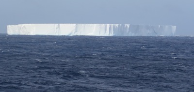
    Tabular ice berg
    My first iceberg off the starboard side. In a word magnificent.

    Within seconds I grabbed my sun glasses, and headed up the five flights of stairs to get a glimpse from the bridge. In a word, magnificent. A glorious tabular ice shelf, floating by.
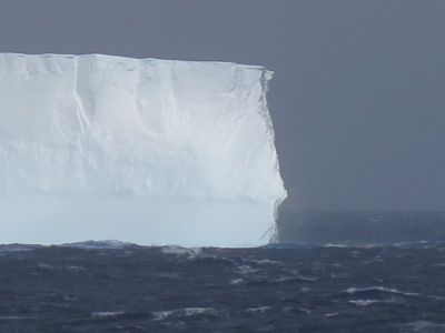
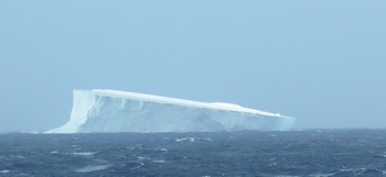
    Tabular Iceberg
    A close up showing some of the visible definition.

    Tabular iceberg
    Yes another iceberg, but I am totally enamored by their majesty.

    As you can see through the pictures, I was enamored by the ice bergs, and as a whole the entire day was a wonderfully cool and chilly, we even started the morning with snow on the deck.

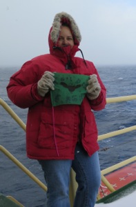
    Cromer Middle School, Flagstaff, Arizona
    Thanks to Cromer Middle School for following along, Maybe by having your flag in the snow we will have a great snow winter at home this year!

    Holden Middle School, Missouri
    Thank you Holden 5th Grade Eagles for following along on our expedition!

    After all our iceberg gawking and snow play it was time for science. Tomorrow we will arrive at South Georgia and Bird Island. The GPSA Global Positioning System (GPS) is a satellite-based navigation system used to track the location or position of objects on the Earth’s surface. team is getting ready to set up the first GPSA Global Positioning System (GPS) is a satellite-based navigation system used to track the location or position of objects on the Earth’s surface. unit. ( a total of three for the entire research cruise) Bob and Nico are the leads and tomorrow my journal will be all about their work and its importance to looking at the movement of different land masses.
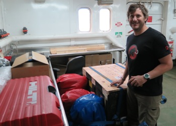
    preparing for GPS installation
    Nico checking all the GPS equipment prior to tomorrows first day of official science.

    Bird Island and all of South Georgia is a very unique ecosystem, and with invasive species many indigenous plants and animals are at risk. Each person going ashore has had their clothing checked for any plant matter, seeds, any hangers on that might contaminate the existing ecosystem. The government of South Georgia is working diligently to ensure the integrity of their ecosystems.
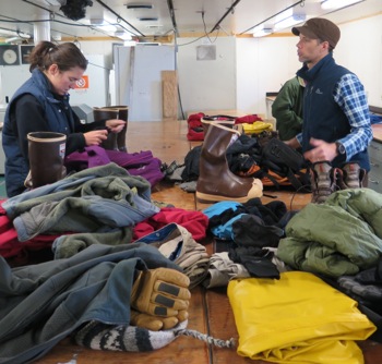
    Graham and the clothing check
    All clothes going ashore need to be checked for any foreign invader species.

    And as we end another day I think upon tomorrow with excitement: land and the possibility of going ashore.

    Date
    Weather Summary
    chilly, a bit rainy, dappled sunlight

    Comments

    Keke Chambers

    Hello Mrs. Worssam, I have a few questions about that humougous ice berg. How big is it ? What feeling did you get seeing your first ice berg. I could visulize you just smiling away taking pictures. Has your team seen any other ships while spending your time there ?
    Thanks

    Tanner Wuollet

    Hi, I would love to see an iceberg in real life! It will be so cool seeing that much ice in one block. The other day I was wondering if the weather changes every day or if it slowly changes over the days. Also how fast do you cruise in that big ship. Last in the ocean is it true that most of the iceberg is under water.

    Kelly B

    Hi Ms. Worrssam, its nice to hear you saw your first iceberg, what a sight! What catches my interest is how you graph your GPS. How do you do it? How do you test the temperature in the water? I hope your enjoying your trip and I can't wait to read more journals.

    Jacob Carpenter

    I have some questions for you:How fast is the Atlantic current moving? How are the GPS conected to Gorgia?
    Those are my questions for this week, keep warm.
    Jacob

    Nakota Pete

    Hello Ms. WorssamHow big was the glacier that you saw?
    How much GPS equipment do you have to carry?
    What are resaerching and how?

    Gavin Freeman

    Hello Mrs.Worssam, Im just wondering how big was that ice burg you guys saw? And how big the waves are there? And that how much equiptment do you have to carry?

    Cedric Benally

    Good morning Ms. Worssam! :) how much weight do you carry all together? how fast are the currents? how high do the waves rise to there? how was it seeing your very first ice glacier? I bet it was a great sight, seeing a huge block of ice in the middle of the ocean. These are my questions hope ypu stay warm and stay safe!

    Jasmine koppe

    Hello Ms. Worssam How big was the iceberg? Were you really close to the iceberg? Also how do you manage to get data out there? Is there internet on the ship? What are the names of the Scientists your working with? Do you miss being in Flagstaff?

    sierra ward

    Hi Ms. Worssam , I have a couple of questions. How big was the ice berg?? Was the ship close to the ice berg?? Also what are the names of the scienists you are working with?? Are they doing the same research as you??

    Matthew horn

    Hi ms. worrssam i was just wondering how meany miles you have covered so far. thank for exiling how some things work and how are u gating the date u back. are u griting it on a graff or what and what els are u doing to lerin how the sea forl is speding o and are u using cumputers to mesher the sea forl. thx age.

    Edith Rodriguez

    Hello Ms. Worssam,What was your feeling when you first saw the iceberg? Also, was your ship close to the iceberg?

    Kaitlyn Snopek

    Hello Ms. Worssam,I wondering, how close did you get to the iceburg that you saw? Also, are you doing research on iceburgs, or other objects where you are, or are you just sticking to sea floor spreading? I hope you are having an amazing time!

    Samantha Hampton

    Samantha Hampton

    Dear Mrs Worssam:
    Based on the picture of the iceburg you posted it looks huge! Did you and your team get and exact measurement of it and if so how do you measure an iceburg while on the boat? Also have you had any horrible storms with big waves? I understand you are in the roughest sea so there have to be some storms.

    Sincerely, Samantha Hampton

    Jaimee Berg

    Hi Ms. Worrsam,So glad to see you having a wonderful time! I was wondering when you saw the Icberg did you make measurments of how wide, long, or the mass of it would be? If you did, how would you make those measurments?

    Have Fun!

    Ragan Horn

    Hello Ms.Worssam,
    I was wondering on how big was that gigantic iceberg you saw? and is the climate at all afecting it? Just one more thing, is the temperture of the water out there cold enough that it is not affecting the iceberg at all?

    Sarah Chatter

    Hi Ms. Worssam,I hope you're having a great time out there. First of all, I wondering how big that iceberg was? Also, how many people are on the ship with you? That's it for now.

    Kaitlyn Snopek

    Hello, Ms. Worssam, I was wondering, how close did you get to the iceberg? Also, is anyone doing any research about icebergs or anyother subject, or is everyone studying sea floor spreading? I hope you are having an amazing trip!!

    Jillian Worssam

    Hi Dad, You are a goof, and no we are not going to cross the international date line. But I love you, and thanks for asking a
    question. Love, Jillian

    On 2014-09-28 09:51, webmaster@polartrec.com wrote:

    Zoe Bartlett

    Dear Ms. worssam,These icebergs are awesome!!! Now i have a question. On the one picture that says " A close up showing some of the visible definition" the iceberg looks incredibly tall and I would just like to know how tall (approximately) was it?
    Sincerely,
    Zoe Bartlett

    Jillian Worssam

    Hi Kelly, Thanks for writing. The GPS work we are hoping to accomplish is to set up three new stations to record the movement of the
    land through the use of GPS location. So far we have not yet made it to
    shore, but our hopes are high. The water part of your question is easy.
    The ship is designed with all sorts of instruments for collecting data
    and one is for sea water to go through some instruments and we can learn
    about the salinity and temperature of the water. Thanks for the great
    question. Ms. Worssam

    On 2014-09-29 08:06, webmaster@polartrec.com wrote:

    Jillian Worssam

    Hi Tanner, Thanks for writing. The ship when collecting data changes its speed depending not he research we are conducting. Right now we are
    using the multi beam so the ship is moving at 10 knots. When we use the
    seismic streamer we travel at around four knots. The weather here is
    just like anywhere else in that we can check on the computer and see the
    predictions for the coming days. And depending on the weather we change
    the research we are conducting and where we are. Thanks for writing.
    Ms. Worssam

    On 2014-09-29 08:06, webmaster@polartrec.com wrote:

    Jillian Worssam

    Hi Lisa, Thanks for writing. I was just talking with the scientists and between the solar panels and wind generators the GPS stations are
    expected to last for years, unless physically damaged. Just yesterday
    we went into King Edward Cove, sadly unable to land due to the wind at
    close to 50 knots, but we could see from the vessel remnants of the
    whaling infrastructure. Looked fascinating. Thanks for following
    along, and thanks for the question. Jillian

    On 2014-09-28 05:59, webmaster@polartrec.com wrote:

    colton dana

    how fast are the currents? how high do the waves rise to there? how was it seeing your very first ice glacier? I bet it was a great sight

    cortland adair

    Hello Ms.Worssam how has it been down there? That iceberg that you saw what time was it and how tall is it? if you can get back to me that will be great.

    sincerly, Cortland adair

    Jillian Worssam

    Hi Jamiee, What a great question. I have no idea how scientists measure icebergs. We only saw a small portion as most of the iceberg is
    below the surface, and the portion we saw was huge. We were over a mile
    away from the iceberg and it totally dwarfed the vessel. This would be a
    great question to google, and then you could teach me for the next time
    we see an iceberg. Thanks. Ms. Worssam

    On 2014-09-29 10:07, webmaster@polartrec.com wrote:

    Jillian Worssam

    Hi Kaitlyn, Thanks for the question. Currently there are no scientists on board studying the icebergs. Our team is all about sea
    floor spreading and how land is moving and its relationship to the ACC.
    Thanks for asking. Ms. Worssam

    On 2014-09-29 10:09, webmaster@polartrec.com wrote:

    Deatiny Yazzie

    Wow Mrs. Worssam Your first iceberg looks humungous!!!
    Do you know how thick the iceberg was? if you do could you please reply back and tell me? I can't believe that your on the other side of the equator!!!!
    Did it take some time to adjust to the time over there?

    Briana Bahe

    Dear Ms. Worssam, What do you think the mass and height of that iceberg was?

    Douglas White

    Hi Ms.Worrsam I was wondering how long and how big was the iceberg. Also is everyone on the ship learning about the same thing or is everyone learning something different

    Jillian Worssam

    Hi Destiny, The time here is only four hours ahead of Flagstaff, so not too hard at all. And you know what, I can hardly believe I am here
    as well. It is a bit amazing. Who knows, maybe someday you will be a
    scientific explorer and be down here your self! Thanks for writing.
    Ms. Worssam

    On 2014-09-29 16:39, webmaster@polartrec.com wrote:

    Jillian Worssam

    Hi Briana, Thanks for the great question. I do not know the mass and height. I was talking with the captain and 1st mate on the bridge and
    we estimated that our berg was a few kilometers in length and the
    captain was telling me that estimates now are that 5/6th of the berg was
    underwater and not visible to us. Ship captains steer clear of large
    icebergs as they can be very dangerous. I would check out the the
    national ice center..do a google as I think they actually track large
    icebergs. Thanks for writing. Ms. Worssam

    On 2014-09-29 17:41, webmaster@polartrec.com wrote:

    Jillian Worssam

    Hi Ragan,
    The water is cold, approximately .7 degrees c. Yes the iceberg will
    melt, how long depends on the original size of the iceberg and where it
    travels to. Thanks for asking. Ms. Worssam

    On 2014-09-29 10:07, webmaster@polartrec.com wrote:

    Jillian Worssam

    Hi Cedric, Thanks for asking. I think if you check a lot of these questions have already been answered. And yes, seeing that big iceberg
    was amazing, in a word it was stunning! Thanks again. Ms. Worssam

    On 2014-09-29 09:06, webmaster@polartrec.com wrote:

    Jillian Worssam

    Hi Samantha, Thanks for writing. We did not get an exact measurement. Approximately 4 kilometers long and very hard to tell with height as
    most of the iceberg is underwater. Some storms, not too bad. We have
    been pretty fortunate. Thanks for writing. Ms. Worssam

    On 2014-09-29 10:05, webmaster@polartrec.com wrote:

    Jillian Worssam

    Hi Nakota, Thanks for the questions. I think I have already answered most of these. I would suggest you check out some of the other blog
    entries. Ms. Worssam I look forward to your next question in
    complete paragraph format.

    On 2014-09-29 08:09, webmaster@polartrec.com wrote:

    Jillian Worssam

    Hi Jaylen, Thanks for the great comments. To collect the data we are collecting not he sea floor uses a combination of three sets on
    scientific instruments. Two are attached to the bottom of the vessel,
    and the other is actually a device that is placed in the water behind
    the vessel. Check out some of the newer blogs and you will see some
    more information about the seismic. Thanks for asking. Ms. Worssam
    Oh, and we have not seen any other vessels since we have been at sea.

    On 2014-09-28 22:20, webmaster@polartrec.com wrote:

    Lisa Seff

    Hi Jillian! Wow, well, you're first iceberg is definitely a keeper! That is massive, and I'm sure only the beginning! Fingers crossed you'll get to go ashore on South Georgia or Bird Island-that would be amazing, and pretty neat to follow along and see exactly how the team uses their GPS systems. I'm curious to see where and how they situate them....and how long they think they'll run successfully given the environment. The history of those islands is so unique too, it will be interesting to see if you find much left over from past involvement with whaling, sealing and/or wartime activities.
    take care and safe seas-Lisa
    p.s.
    and another "Wow!" I got a bunch of e-mails yesterday from students who saw our flag in your last journal, they were/are SO excited! You know you're doing an amazing job when they're following you and your science team, even over a long weekend! (we had Thursday and Friday off) (: Also makes for a happy science teacher!

    Dad

    Are you going to cross the international date. Line

    Matthew Horn

    Hi Ms WorrsamI was wondering how big that iceberg was? How many people are on the Scienctific team with you? How big are the multi-beam and the echo sounder? what do they do? How many students are teaching you on the ship?

    Blanca Trombatore

    Thank you for all the information!! We are following the RVIB Nathaniel B Palmer because our son Michael is working as a Chef on board for the first time and we are At awe of all the the info. Thank you

    Jillian Worssam

    Hi Matthew, Great questions. The iceberg was BIG, not sure how big but for sure many football fields big! there are 46 people on board and
    it is a combination of scientists, crew, tech staff. It is a great
    group of people. The multibeam is set up in two parts: the parts that
    send down the pulse are approximately 90 meters in length and are the
    transducers. the receivers are across the beam of the vessel,
    approximately 12 meters across. Scientists map the sea floor with sound
    and the reflection of sound. And Matthew, there are six students on
    board from the University of Texas in Austin, and they re all super at
    teaching me. I also have lots of drawings to help me understand.

    Thanks fro following along Matthew, great questions. Ms. Worssam

    On 2014-09-28 12:59, webmaster@polartrec.com wrote:

    Jillian Worssam

    Hi Blanca, Thanks for writing. A funny coincidence, I am playing rummy 500 with Michael as I write this response. Please let us know if
    you have any questions. Jillian

    On 2014-09-28 15:47, webmaster@polartrec.com wrote:

    Yamile Lujan

    Hi Ms.Worssam, i was just wondering how big the iceberg was? How close were you guys to the iceberg? What are the names of the scientists you are working with?

    Jaylen Orona

    I have a few questions:
    I was wondering how you get your data. Do you physically put something in the water, or do you have other tools for that?

    Is every scientist on board researching Sea Floor Changes as well, or does everyone have a different purpose?

    Have you seen any other ships during your time there?

    Thanks